Area Overview for CW11 3NS
Photos of CW11 3NS

Area Information
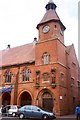
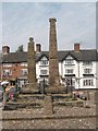
Living in CW11 3NS means inhabiting a compact, residential cluster of 2.5 hectares in the Cheshire Plain, home to 1,610 people. This postcode area sits within Sandbach, a historic market town granted its charter in 1579, blending medieval heritage with modern convenience. The area’s population density of 1,302 people per square kilometre reflects a tightly knit community, where daily life is shaped by proximity to Sandbach’s market square, shops, and rail links. The town’s history as a coaching stop and industrial hub—once home to silk mills and Foden lorries—lends a sense of continuity. Residents benefit from easy access to Sandbach’s Thursday market, monthly Farmers’ Market, and the Anglo-Saxon Sandbach Crosses, preserved by English Heritage. With a median age of 47 and a majority of adults aged 30–64, the area is characterised by stability, with 78% of homes owner-occupied. This is a place where tradition meets practicality, offering a quiet yet connected lifestyle.
- Area Type
- Postcode
- Area Size
- 2.5 hectares
- Population
- 1610
- Population Density
- 1302 people/km²
The property market in CW11 3NS is dominated by owner-occupied homes, with 78% of residents living in houses rather than flats or rental properties. This reflects a community prioritising long-term stability over transient tenancy. The small area size of 2.5 hectares means the housing stock is compact, with limited scope for new developments. Buyers should expect a mix of traditional and modern homes, given Sandbach’s historical role as an industrial and market town. The high home ownership rate suggests strong local attachment, potentially leading to competitive demand for available properties. For those considering the area, the focus on houses rather than apartments indicates a preference for private, low-density living. Proximity to rail stations and amenities also enhances the appeal of owning a home here.
House Prices in CW11 3NS
No properties found in this postcode.
Energy Efficiency in CW11 3NS
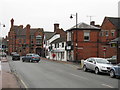
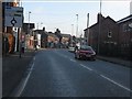
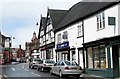
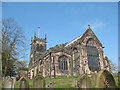
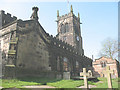
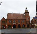
The lifestyle in CW11 3NS is enriched by nearby amenities, including retail outlets such as Aldi Arclid, Waitrose Sandbach, and Iceland Sandbach, which provide everyday shopping convenience. The area’s proximity to Sandbach’s Thursday market and monthly Farmers’ Market adds a vibrant, community-focused element to daily life. The town centre features shops, bars, and the historic St Mary’s Church, where ancient stone fragments are on display. Cultural landmarks like the Anglo-Saxon Sandbach Crosses, managed by English Heritage, offer historical depth. The presence of rail stations, including Sandbach Railway Station, ensures easy access to wider destinations. This blend of retail, historical sites, and transport options creates a lifestyle that balances tradition with modern practicality, ideal for those seeking a connected yet tranquil environment.
Amenities
Schools
The schools nearest to CW11 3NS include Sandbach School, which operates as both an independent institution and an academy with a good Ofsted rating. This dual presence offers families choice, with the academy’s good rating reflecting strong educational standards. The independent school caters to those seeking alternative educational models, while the academy provides a publicly funded, high-quality option. The coexistence of both school types suggests a diverse educational landscape, accommodating different preferences and needs. For families prioritising academic performance, the good Ofsted rating at Sandbach School is a significant advantage. The proximity of these schools to the area ensures ease of access for residents, reinforcing the area’s appeal for families.
| Rank | School | Type | Entry gender | Ages |
|---|
Explore more schools in this area
Go to Schools tabDemographics
The community in CW11 3NS is predominantly composed of adults aged 30–64, with a median age of 47. This suggests a mature, established population, likely with long-term ties to the area. Home ownership is high at 78%, indicating a stable residential base, with houses being the primary accommodation type. The predominant ethnic group is White, though specific data on diversity is not provided. The age profile and ownership rates suggest a low turnover of residents, fostering a sense of continuity. With no data on deprivation, it is reasonable to infer that the area’s quality of life is supported by its infrastructure and amenities. The population density of 1,302 people per square kilometre implies a mix of single-family homes and small households, typical of a small town setting.
Household Size
Accommodation Type
Tenure
Ethnic Group
Religion
Household Composition
Age
Household Deprivation
NS-SEC
Explore more demographic insights in this area
Go to Demographics tabPlanning
Planning Constraints
- Flood RiskPremium
- Ramsar Wetland SitesPremium
- Area of Outstanding Natural BeautyPremium
- Protected Nature ReservePremium
- Protected WoodlandPremium