Area Overview for CW1 2JR
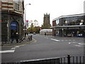
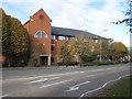
Photos of CW1 2JR
Area Information
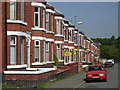
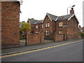
CW1 2JR is a small residential postcode area in Cheshire East, England, encompassing the village of Crewe Green and surrounding areas. With a population of 1,926, it is a compact community characterised by dispersed housing, historic sites, and proximity to Crewe town centre. The area’s name reflects its historical roots as a former civil parish, now merged into Weston and Crewe Green. Residents live in a mix of homes and farms, with notable landmarks including the grade-I-listed Crewe Hall and 201 hectares of protected parkland. The village sits 1½ miles east of Crewe, offering access to local amenities while retaining a rural feel. Daily life here balances quiet village living with connections to nearby towns. The area’s transport links include rail services to Crewe, Nantwich, and Sandbach, and roads like the B5077. For those seeking a blend of history, green space, and practical connectivity, CW1 2JR offers a distinct slice of Cheshire’s character.
- Area Type
- Postcode
- Area Size
- Not available
- Population
- 1926
- Population Density
- 5029 people/km²
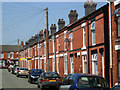
The property market in CW1 2JR is defined by a low home ownership rate of 21%, suggesting that most properties are rented rather than bought. The accommodation type is predominantly houses, which are typically larger and more spread out than flats or apartments. This contrasts with areas where rental markets dominate, as CW1 2JR’s housing stock appears to cater to buyers seeking traditional homes rather than modern apartments. The small size of the postcode area means the local market is limited, with buyers likely looking to nearby towns like Crewe for more options. The low home ownership rate may indicate a reliance on private rentals or shared ownership schemes. For those considering purchase, the area’s rural character and proximity to Crewe could be appealing, though the limited data on property availability or prices means further local research is necessary.
House Prices in CW1 2JR
No properties found in this postcode.
Energy Efficiency in CW1 2JR
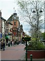
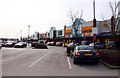
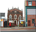
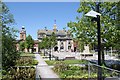
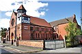
Residents of CW1 2JR have access to essential retail amenities within practical reach, including Asda Crewe, Morrisons Crewe, and Farmfoods Crewe. These stores provide groceries, household items, and other daily necessities. The area’s transport links to Crewe, Nantwich, and Sandbach stations offer connections to larger towns for additional shopping, dining, and entertainment. Locally, the village of Crewe Green features historical sites like St Michael and All Angels Church and the grade-I-listed Crewe Hall, which functions as a hotel and restaurant. The 201 hectares of parkland, including Rookery Wood and Temple of Peace Wood, provide green space for walking, picnics, or leisure. While the area’s small size limits large-scale amenities, its blend of rural tranquillity and nearby town access creates a balanced lifestyle for those prioritising nature and convenience.
Amenities
Schools
Nearby schools in CW1 2JR include Beechwood Primary School and Nursery, which holds an Ofsted rating of ‘good’, and Victoria Community Technology School, a primary school without a specified rating. Adelaide School, a special school, is listed twice in the data, though its exact location within the area is unclear. Crewe Secondary Unit is also nearby but classified as ‘other’, possibly indicating a specialist or alternative education provider. The presence of both primary and special schools suggests a range of educational options for families, though the absence of secondary school data may limit choices for older children. The ‘good’ rating at Beechwood Primary could be a key selling point for families prioritising quality early education. However, the lack of detailed information on school performance or capacity may require further investigation for prospective buyers.
| Rank | School | Type | Entry gender | Ages |
|---|
Explore more schools in this area
Go to Schools tabDemographics
The population of CW1 2JR is 1,926, with a median age of 47 and the most common age range being adults aged 30–64. This suggests a community skewed towards middle-aged residents, likely with established careers and families. Home ownership in the area is low at 21%, indicating that the majority of properties are rented rather than owner-occupied. The predominant accommodation type is houses, reflecting a more traditional housing stock compared to high-density developments. The predominant ethnic group is White, though no data is provided on other groups. The age profile and home ownership rate suggest a mix of long-term residents and renters, with limited data on socioeconomic deprivation. This demographic profile may appeal to those seeking stable, low-maintenance housing in a semi-rural setting.
Household Size
Accommodation Type
Tenure
Ethnic Group
Religion
Household Composition
Age
Household Deprivation
NS-SEC
Explore more demographic insights in this area
Go to Demographics tabPlanning
Planning Constraints
- Flood RiskPremium
- Ramsar Wetland SitesPremium
- Area of Outstanding Natural BeautyPremium
- Protected Nature ReservePremium
- Protected WoodlandPremium