Area Overview for CW1 1FG
Photos of CW1 1FG


Area Information
CW1 1FG is a small, tightly knit residential area nestled in Cheshire East, just east of Crewe town centre. With a population of 1,516 and a high density of 1,072 people per square kilometre, it reflects the compact nature of a village cluster rather than a sprawling suburb. The area’s history is rooted in its connection to Crewe Green, a former civil parish now merged into Weston and Crewe Green. Dispersed homes, farms, and industrial estates like Crewe Hall Enterprise Park define its landscape, blending rural charm with practical infrastructure. Residents here are likely to value proximity to Crewe’s amenities while enjoying a quieter, more residential environment. The area’s compact size means daily life is centred around nearby services, with easy access to rail links and local shops. Its location near Crewe Hall, a historic Jacobean mansion, adds a touch of heritage to the community. For those seeking a balance between small-town tranquillity and connectivity to larger urban hubs, CW1 1FG offers a distinctive blend of character and practicality.
- Area Type
- Postcode
- Area Size
- Not available
- Population
- 1516
- Population Density
- 1072 people/km²
The property market in CW1 1FG is characterised by a high rate of home ownership (69%) and a focus on houses rather than flats or apartments. This suggests a community prioritising private, family-oriented living spaces over rental properties. The compact nature of the area, with a population density of 1,072 people per square kilometre, means the housing stock is limited, likely centred on individual homes rather than large developments. Buyers should expect a market where properties are predominantly owner-occupied, with fewer opportunities for short-term rentals or speculative investment. The presence of industrial estates like Crewe Hall Enterprise Park nearby may influence property values, though the residential cluster itself remains small and defined by its rural-to-urban balance. For those seeking a home in CW1 1FG, the market is likely to be competitive, with limited options but a strong emphasis on traditional, stable housing.
House Prices in CW1 1FG
No properties found in this postcode.
Energy Efficiency in CW1 1FG
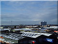
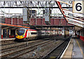
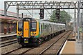
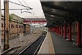
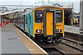
Living in CW1 1FG offers a blend of practicality and small-town convenience. Nearby amenities include retail options such as Tesco Crewe, Co-op Gateway, and Lidl Dorothy, providing essential shopping needs within reach. The area’s railway stations—Crewe, Nantwich, and Sandbach—offer easy access to commuting routes and regional travel. For leisure, the Crewe and Nantwich Circular Walk provides a scenic route for walking or cycling. The presence of Crewe Hall, a historic estate with parkland and woodlands, adds a touch of natural beauty to the area. While the residential cluster itself is compact, its proximity to Crewe ensures residents can access larger cultural and recreational facilities. The lifestyle here is defined by accessibility to basic services, a quiet environment, and the ability to balance rural tranquillity with urban connectivity.
Amenities
Schools
The schools nearest to CW1 1FG include Hungerford Primary School and Hungerford Primary Academy, both of which are primary schools. One of the academies holds an Ofsted rating of ‘satisfactory’, indicating a baseline standard of education but no outstanding performance. The presence of two primary schools within the area provides families with options for their children’s early education, though the lack of secondary schools nearby may require commuting to Crewe or surrounding towns. The mix of school types suggests a focus on foundational education, but the absence of higher-rated institutions could be a concern for parents prioritising academic excellence. Families considering CW1 1FG should factor in the need for additional travel for secondary education and assess whether the available primary schools meet their expectations for teaching quality and facilities.
| Rank | School | Type | Entry gender | Ages |
|---|
Explore more schools in this area
Go to Schools tabDemographics
The community in CW1 1FG is predominantly composed of adults aged 30–64, with a median age of 47. This suggests a mature population, likely with established careers and families. Home ownership is high at 69%, indicating a stable, long-term resident base. The accommodation type is primarily houses, reflecting a preference for single-family living rather than apartments or flats. The predominant ethnic group is White, with no specific data provided on other demographics. The absence of detailed diversity statistics means the community’s cultural composition remains less defined. The age profile and ownership figures imply a settled, low-turnover environment. However, the high proportion of middle-aged residents may mean fewer amenities tailored to younger families or retirees. The area’s character is shaped by its demographic consistency, with a focus on traditional housing and a population that values stability over transient lifestyles.
Household Size
Accommodation Type
Tenure
Ethnic Group
Religion
Household Composition
Age
Household Deprivation
NS-SEC
Explore more demographic insights in this area
Go to Demographics tabPlanning
Planning Constraints
- Flood RiskPremium
- Ramsar Wetland SitesPremium
- Area of Outstanding Natural BeautyPremium
- Protected Nature ReservePremium
- Protected WoodlandPremium