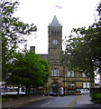
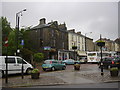
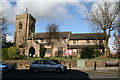
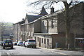
Area Overview for Colne
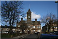
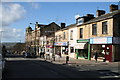
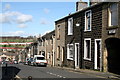
Photos of Colne

Area Information
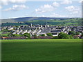
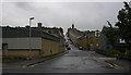
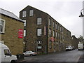
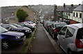
Colne is a built-up area situated within Lancashire, England, with a distinct character shaped by its modest scale. The settlement covers a total area of 4.8 km², resulting in a population density of 800 people per square kilometre. This size classifies it as a small town where residents often know one another. The total population stands at 3,826 people, indicating a relatively quiet residential environment compared to larger urban centres. Living in Colne offers the benefit of a close-knit community structure without the congestion of major cities. The neighbourhood layout supports a straightforward daily routine, as amenities and essential services remain within practical reach. You will find that the area functions as a self-contained hub for local life. The balance between population size and land area creates an accessible setting for families and individuals seeking stability. Commuters rely on nearby railway stations, while shoppers utilise local retail outlets. The demographic profile reflects a settled community, with a significant portion of the population comprising older adults. This quiet atmosphere defines the experience of raising a family or enjoying a peaceful retirement in this specific built-up zone.
- Area Type
- Built Up Area 250
- Area Size
- 4.8 km²
- Population
- 3826
- Population Density
- 800 people/km²
Daily life in Colne revolves around a compact network of amenities within practical reach of all homes. Retail options are well represented by five key establishments in the immediate vicinity. Notable supermarkets include Tesco Colne, Farmfoods Colne, and Aldi Colne, providing essential groceries and household goods. This variety ensures you can find different price points and shopping experiences without needing to travel far. Transportation access is further supported by five rail-related facilities, with Colne Railway Station serving the local population directly. Nelson Railway Station and Brierfield Railway Station are also accessible, offering broader regional connectivity. The density of five shops and five rail facilities within the area underscores the convenience of living here. You can manage your weekly shopping and travel plans without relying on long-distance journeys. The arrangement of these amenities fosters a self-sufficient lifestyle where most daily needs are met locally. The proximity of these essential services supports the community's routine, allowing residents to focus on home and leisure rather than logistics.
Amenities
Schools
Families residing in Colne benefit from several educational institutions within the immediate vicinity. Newtown Nursery School serves the youngest children in the locality. Several primary schools cater to the younger school-age population, providing local education options. These include Laneshaw Bridge Primary, Colne Lord Street School, Colne Primet Primary School, and Park Primary School. Of particular note is Park Primary School, which holds a Ofsted rating of good, reflecting standard educational quality. Colne Primet Primary School also carries a Ofsted rating of good, offering another secure choice for local families. The concentration of primary schools within the town limits reduces the need for long-distance travel to secondary education centres for younger children. This clustering of nursery and primary facilities supports working parents who require convenient schooling arrangements. The presence of multiple primary options allows families to select based on catchment areas or specific educational philosophies without leaving the immediate neighbourhood.
| Rank | School | Type | Entry gender | Ages |
|---|
Explore more schools in this area
Go to Schools tabDemographics
The community in Colne is defined by a mature population profile, with a median age of 70 years. This statistic indicates that the majority of residents fall into older age brackets, suggesting a significant retiree presence. Home ownership is the dominant housing tenure model, accounting for 61% of the local population. This high rate of ownership points to long-term settlement and investment in the property market rather than a transient rental lifestyle. While household composition details are not explicitly broken down by type in the available records, the high ownership percentage implies many family homes or bungalows suitable for older adults. The area does not report specific ethnic group or religious data in the current records, meaning these demographics are not detailed in standard aggregates. Nevertheless, the overall picture is one of stability. The combination of an older median age and high home ownership levels creates a predictable living environment. You can expect neighbours who have lived in their properties for decades. This demographic structure influences local services, particularly healthcare and leisure facilities catering to older adults. Consequently, the social fabric of Colne revolves around the needs and routines of its senior residents.
Household Size
Accommodation Type
Tenure
Ethnic Group
Religion
Household Composition
Age
Household Deprivation
NS-SEC
Explore more demographic insights in this area
Go to Demographics tabPlanning
Planning Constraints
- Crime RiskPremium