Area Overview for Cleator Moor West Ward
Photos of Cleator Moor West Ward
Area Information
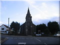
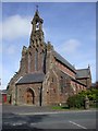
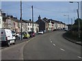
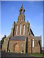
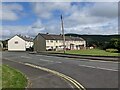
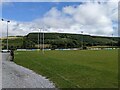
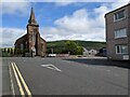
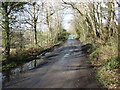
Living in Cleator Moor West Ward places you within a small former market town that spans 11.6 km² in the north of England. This electoral ward centres on Cleator Moor and extends to include Cleator village, creating a compact community of roughly 3,918 people. The area sits on the edge of the Lake District National Park, overlooking Dent Fell, which marks the first ascent of the Wainwright Coast to Coast Walk. You are surrounded by distinct communities such as Mill Hill, Bowthorn, and Wath Brow, which form a single built-up area with a strong working-class character tied to its industrial heritage. Daily life revolves around local sports clubs, including the rugby league team Cleator Moor Hornets and a cricket club. The weekly market on the town square remains a social focal point, supported by community facilities like Crossfield Community Centre and the Phoenix Enterprise Centre. The ward contains notable green spaces, including Longlands Lake, a former iron ore site that now serves as a wildlife spot south towards Egremont. You will find designated play areas and McGrath Park, which hosts Celtic FC. While public transport options outside the ward are limited, the disused railway line has been converted into the Sea to Sea cycle route, part of the National Cycle Network, offering a key artery for recreation and local travel.
- Area Type
- District Borough Unitary Ward
- Area Size
- 11.6 km²
- Population
- Not available
- Population Density
- Not available
Demographics
The community in Cleator Moor West Ward features a resident population with a median age of 70 years. This indicates a demographic skewed significantly towards older adults who have settled in the area. Household data reflects a household composition where 65% of residents own their homes outright. This high rate of owner-occupation suggests stability within the ward, as the majority of families have established long-term roots rather than relying on the private rental sector. Accommodation types generally align with the history of a former industrial town, though specific breakdowns of dwelling structures are not detailed in the current records. Ethnic diversity and religious affiliation exist within the ward, but specific statistics on predominant groups or denominations are not provided in the dataset. You must rely on the general character of the community described in local histories, which mention Irish immigration during the late 19th century due to iron mining. The most common age range covers the total population, reinforcing the picture of an older demographic. This profile typically means the local demand for housing focuses on properties suitable for retirees or established families rather than young professionals entering the market for the first time. The area functions as a quiet retreat for those prioritising proximity to nature and established community cohesion.
Household Size
Accommodation Type
Tenure
Ethnic Group
Religion
Household Composition
Age
Household Deprivation
NS-SEC
Explore more demographic insights in this area
Go to Demographics tabPlanning
Planning Constraints
- Flood RiskPremium
- Ramsar Wetland SitesPremium
- Area of Outstanding Natural BeautyPremium
- Protected Nature ReservePremium
- Protected WoodlandPremium
- Crime RiskPremium