Area Overview for CH64 3RA
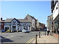
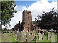
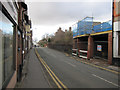
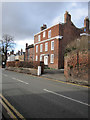
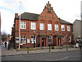
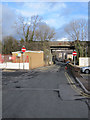
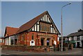
Photos of CH64 3RA
Area Information
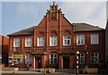
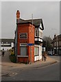
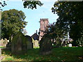
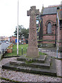
Living in CH64 3RA means inhabiting a small, tightly knit residential cluster in the heart of Neston, a historic market town in Cheshire’s Wirral Peninsula. With a population of 2,480 spread across just 1.1 hectares, the area feels intimate, with a density of 226,378 people per square kilometre. Neston’s character is shaped by its Viking-era origins, its role as a former port, and its retention of historic buildings like the 14th-century Parish Church of St Mary and St Helen. Daily life here balances tranquility with accessibility: the town’s Friday market and monthly Farmer’s Market continue its heritage as a commercial hub, while nearby rail links connect to Birkenhead and Wrexham. The area’s compact size means amenities are within easy reach, and its low flood risk and absence of protected natural sites make it practical for long-term living. For those seeking a mix of history, convenience, and community, CH64 3RA offers a snapshot of rural Cheshire with a modern infrastructure footprint.
- Area Type
- Postcode
- Area Size
- 1.1 hectares
- Population
- Not available
- Population Density
- Not available
The property market in CH64 3RA is defined by its low density and focus on houses. With 43% of homes owner-occupied, the area is neither heavily rental-driven nor overwhelmingly private ownership. The predominance of houses suggests a market geared towards families or individuals seeking space, though the small area size means housing stock is limited. Buyers should consider that the cluster’s compact nature restricts availability, and properties may be more competitive than in larger towns. The absence of flats or apartments indicates a traditional housing stock, which could appeal to those prioritising garden space or suburban living. Proximity to Neston’s amenities and transport links adds value, but the small footprint means buyers must weigh practicality against the area’s historic charm.
House Prices in CH64 3RA
Showing 21 properties
| Address | Type | Beds | Baths | Last Sale Price | Last Sale Date | |
|---|---|---|---|---|---|---|
| 28 Liverpool Road, Neston, CH64 3RA | house | 2 | 1 | £205,000 | Aug 2022 | |
| 48 Liverpool Road, Neston, CH64 3RA | Terraced | 3 | 2 | £155,000 | Aug 2020 | |
| 26 Liverpool Road, Neston, CH64 3RA | Terraced | 2 | 1 | £115,000 | Sep 2017 | |
| 50 Liverpool Road, Neston, CH64 3RA | Semi-detached | 3 | 1 | £71,950 | Sep 2002 | |
| 30 Liverpool Road, Neston, CH64 3RA | Terraced | 2 | 1 | £40,000 | Dec 2001 | |
| 54 Liverpool Road, Neston, CH64 3RA | house | - | - | £54,500 | Dec 1999 | |
| 2A Liverpool Road, Neston, CH64 3RA | Semi-detached | 2 | 2 | - | - | |
| Flat, 8 Liverpool Road, Neston, CH64 3RA | Terraced | 3 | - | - | - | |
| 4A Liverpool Road, Neston, CH64 3RA | undefined | - | - | - | - | |
| 20A Liverpool Road, Neston, CH64 3RA | Flat | - | - | - | - |
Energy Efficiency in CH64 3RA
The lifestyle in CH64 3RA is shaped by Neston’s historic character and accessible amenities. Local shops like Aldi, Sainsburys, and Tesco provide daily essentials, while the town’s Friday market and monthly Farmer’s Market offer a taste of its market town heritage. Rail stations such as Neston and Heswall connect residents to broader networks, facilitating both local and regional travel. The area’s compact size means parks and leisure spaces are not explicitly listed, but the town’s historic buildings and quayside remnants suggest opportunities for walking or heritage exploration. The mix of retail, transport, and market traditions creates a convenient, low-stress environment, ideal for those valuing a blend of tranquillity and practicality in their daily lives.
Amenities
Schools
The nearest school to CH64 3RA is Neston CofE Infant School, a primary institution serving the town’s younger residents. While no Ofsted rating is provided, its presence reflects Neston’s commitment to education, with the Friday market and Farmer’s Market complementing family life. The lack of secondary schools in the immediate vicinity means families may need to look further afield for comprehensive schooling. However, the town’s historic market town status and proximity to rail links could ease access to larger educational hubs. For those prioritising primary education, the school’s location within practical reach offers convenience, though the absence of additional schools underscores the need for careful planning when considering long-term family needs.
| Rank | School | Type | Entry gender | Ages |
|---|
Explore more schools in this area
Go to Schools tabDemographics
The population of CH64 3RA skews towards adults aged 30–64, with a median age of 47. This suggests a mature, stable community with a strong presence of middle-aged residents, likely including families and professionals. Home ownership stands at 43%, indicating a mix of owner-occupied and rental properties, though not a strongly rental-dominated area. The predominant accommodation type is houses, reflecting a preference for single-family dwellings over flats or apartments. The majority of residents identify as White, with no specific data on other ethnic groups. This demographic profile points to a low-deprivation area, where quality of life is supported by local services and infrastructure. The age distribution also implies a community with established roots, where generational stability is more common than transient populations.
Household Size
Accommodation Type
Tenure
Ethnic Group
Religion
Household Composition
Age
Household Deprivation
NS-SEC
Explore more demographic insights in this area
Go to Demographics tabPlanning
Planning Constraints
- Flood RiskPremium
- Ramsar Wetland SitesPremium
- Area of Outstanding Natural BeautyPremium
- Protected Nature ReservePremium
- Protected WoodlandPremium