Area Overview for CH63 8QX
Photos of CH63 8QX
Area Information
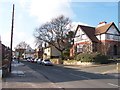
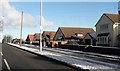
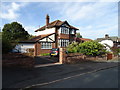
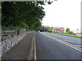
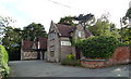
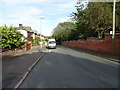
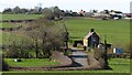
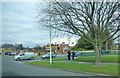
Living in CH63 8QX means being part of a small, tightly knit residential cluster in Wirral, England. This postcode covers 2,201 square metres and is home to 1,596 people, giving it a population density of 263 people per square kilometre. The area’s compact size reflects its traditional village character, rooted in historical trade routes between Chester and Birkenhead. Residents here benefit from a quiet, low-density environment, with the original village centres of Higher Bebington and Lower Bebington offering a sense of continuity. The area’s strategic location on major roads and rail lines has long made it a hub for local commerce, though today it retains a rural feel. With a median age of 47 and a strong presence of adults aged 30–64, the community is stable and family-oriented. The low crime risk score of 85/100 and minimal environmental constraints suggest a safe, well-planned living environment. For those seeking a balance between convenience and tranquillity, CH63 8QX offers proximity to essential services without the pressures of urban life.
- Area Type
- Postcode
- Area Size
- 2201 m²
- Population
- 1596
- Population Density
- 263 people/km²
CH63 8QX is primarily an owner-occupied area, with 83% of residents living in homes they own. The accommodation type is predominantly houses, which is typical of smaller, rural postcodes in Wirral. This suggests a market characterised by family homes and detached properties rather than apartments or rental units. The high home ownership rate indicates a stable, long-term resident base, which can be attractive to buyers seeking a secure investment. The area’s compact size means the housing stock is limited, so properties here are likely to be in high demand relative to their availability. For buyers, this implies a competitive market with potential for capital growth, particularly for those prioritising a low-density, family-friendly environment. The absence of major planning constraints or environmental risks further enhances its appeal as a reliable investment.
House Prices in CH63 8QX
Showing 10 properties
Energy Efficiency in CH63 8QX
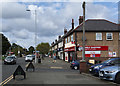
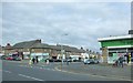
Residents of CH63 8QX have access to a range of local amenities within practical reach. The area is served by five retail outlets, including Sainsburys Bebington and two Co-ops, ensuring everyday shopping needs are met. Rail stations such as Bebington and Port Sunlight provide easy access to regional transport networks, while nearby ferry terminals connect to Liverpool and Birkenhead, facilitating travel across the Mersey. The historical and cultural heritage of the area, including the Church of St. Andrew and Bebington Quarry, adds to its unique character. Though the area is small, its proximity to larger towns like Chester and Birkenhead means residents can access more extensive leisure, dining, and retail options if needed. The combination of local convenience and regional connectivity supports a lifestyle that balances self-sufficiency with access to broader opportunities.
Amenities
Schools
The nearest school to CH63 8QX is Higher Bebington Junior School, a primary school with a good Ofsted rating. This provides families with access to a well-regarded local education option for younger children. The absence of secondary schools in the immediate vicinity means residents may need to consider commuting to nearby towns for secondary education, such as Birkenhead or Chester. However, the presence of a primary school with a good rating is a strong asset for families prioritising quality education. The school’s location within the area reinforces the community’s focus on family life and local amenities. For homebuyers, proximity to a well-rated primary school can be a significant draw, though secondary schooling options may require additional planning.
| Rank | School | Type | Entry gender | Ages |
|---|
Explore more schools in this area
Go to Schools tabDemographics
The population of CH63 8QX is predominantly adults aged 30–64, with a median age of 47. This suggests a mature, established community with a focus on stability. Home ownership is high at 83%, indicating a strong presence of long-term residents and family homes. The area’s accommodation is primarily houses, which aligns with its low-density, village-like character. The predominant ethnic group is White, reflecting the demographic makeup of the wider Wirral region. While specific data on deprivation is not provided, the high home ownership rate and low crime risk suggest a relatively affluent and secure environment. The age profile implies a community with a mix of professionals and retirees, likely contributing to a steady local economy. For buyers, this demographic profile signals a neighbourhood where property values may be resilient, with demand driven by families seeking a settled, low-risk environment.
Household Size
Accommodation Type
Tenure
Ethnic Group
Religion
Household Composition
Age
Household Deprivation
NS-SEC
Explore more demographic insights in this area
Go to Demographics tabPlanning
Planning Constraints
- Flood RiskPremium
- Ramsar Wetland SitesPremium
- Area of Outstanding Natural BeautyPremium
- Protected Nature ReservePremium
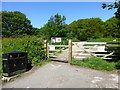
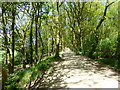
- Protected WoodlandPremium