Area Overview for CH45 8RE
Photos of CH45 8RE
Area Information
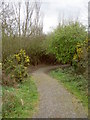
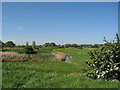
Living in CH45 8RE means being part of a compact, residential cluster in the Leasowe and Moreton East Ward of Wirral, a coastal area in Merseyside. With a population of 2,020 and a density of 1,338 people per square kilometre, this small postcode area blends historical character with modern convenience. The terrain is low-lying, much of it at or below sea level, protected by coastal embankments. Leasowe, a village with Anglo-Saxon roots meaning “Meadow Pastures,” is home to landmarks like Leasowe Castle (Grade II*) and the Leasowe Lighthouse (Grade II), the oldest brick-built lighthouse in Britain. Nearby, the largest sand dune system on the Wirral offers natural beauty, while Second World War coastal fortifications remain as relics of the past. The area is within 2–3 miles of Wallasey, offering access to urban amenities, and its proximity to ferry terminals and rail stations ensures connectivity. Daily life here balances coastal tranquillity with practical access to retail, education, and transport, making it a viable choice for those seeking a mix of history and modernity.
- Area Type
- Postcode
- Area Size
- Not available
- Population
- 2020
- Population Density
- 1338 people/km²
The property market in CH45 8RE is characterised by a 51% home ownership rate, with houses being the primary accommodation type. This suggests a mix of owner-occupied and rental properties, though the exact proportion of rentals is not specified. As a small, defined postcode area, the housing stock is likely limited, with properties concentrated around Leasowe and Moreton. The predominance of houses may appeal to families seeking space, though the compact nature of the area means buyers should consider proximity to amenities and transport links. The relatively high population density for a residential area indicates that properties may be in demand, particularly for those seeking a balance between coastal living and urban accessibility. Buyers should also note the area’s historical features, such as Leasowe Castle, which may influence property values or desirability.
House Prices in CH45 8RE
No properties found in this postcode.
Energy Efficiency in CH45 8RE
Life in CH45 8RE is enriched by nearby amenities that cater to daily needs and leisure. Retail options include Lidl Wallasey, Heron Leasowe, and Aldi Bidston Moss, providing essential shopping within walking or short driving distance. The area’s rail stations—Wallasey Village, Wallasey Grove Road, and Bidston—offer easy access to urban centres, while ferry terminals at Seacombe, Birkenhead, and Woodside Birkenhead connect residents to the surrounding region via water. The coastal proximity means access to natural features like the largest sand dune system on the Wirral and historical sites such as Leasowe Castle and the lighthouse. These elements combine to create a lifestyle that balances practicality with scenic and cultural attractions, ideal for those seeking a mix of convenience and coastal charm.
Amenities
Schools
Nearby schools in CH45 8RE include Castleway Nursery School, which provides early education, and Our Lady of Lourdes Catholic Primary School, rated “good” by Ofsted. Holy Spirit Catholic and Church of England Primary School also holds a “good” rating, offering a range of religious and educational options for families. Other institutions, such as The Link Centre At Solar Campus and Emslie Morgan Alternative Provision School (EMAPS), cater to diverse educational needs, including alternative provision for students requiring tailored support. The presence of both primary schools and alternative provision facilities indicates a comprehensive educational landscape, though no secondary schools are listed in the data. Families should consider the proximity of these schools to their homes and the specific needs of their children, as the mix of school types reflects both traditional and specialised educational pathways.
| Rank | School | Type | Entry gender | Ages |
|---|
Explore more schools in this area
Go to Schools tabDemographics
CH45 8RE has a median age of 47, with the most common age range being adults aged 30–64. This suggests a mature, stable population, likely comprising families and professionals. Home ownership stands at 51%, with houses being the predominant accommodation type, indicating a mix of owner-occupied properties and rental homes. The predominant ethnic group is White, reflecting the area’s demographic composition. The absence of specific deprivation data means quality of life is inferred from amenities and safety assessments. With a population density of 1,338 per square kilometre, the area is moderately populated, offering a balance between community cohesion and personal space. The age profile suggests a population that may prioritise stability and proximity to schools and services, which are well represented in the area.
Household Size
Accommodation Type
Tenure
Ethnic Group
Religion
Household Composition
Age
Household Deprivation
NS-SEC
Explore more demographic insights in this area
Go to Demographics tabPlanning
Planning Constraints
- Flood RiskPremium
- Ramsar Wetland SitesPremium
- Area of Outstanding Natural BeautyPremium
- Protected Nature ReservePremium
- Protected WoodlandPremium