Area Overview for CH43 4UX
Photos of CH43 4UX


Area Information
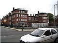
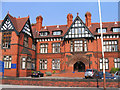
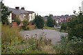
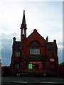
Living in CH43 4UX offers a distinct experience on the Wirral Peninsula, situated within a specific residential cluster just 3 km west of Birkenhead town centre. This postcode covers 1.7 hectares of land, supporting a population of 1693 people. The location lies adjacent to Birkenhead Park, the world's first publicly funded park which opened in 1847 and was designed by Joseph Paxton. Historically, the area connects to Claughton, a village that once included Grange before becoming part of Birkenhead in 1843. The name Claughton derives from Old Norse *Klakkr-tun*, meaning "hamlet on a hillock," indicating Viking origins in a region of Merseyside, England. Residents benefit from proximity to the turbulent past of the area, where Claughton Manor House once stood until the 1930s, and the Birkenhead Institute previously operated on Tollemache Road. The community thrives near the coordinates 53.395879, -3.05311, surrounded by a landscape that retains echoes of its agricultural and industrial history. While the small size of the postcode suggests a tight-knit environment, it serves as a gateway to wider Birkenhead facilities. You can expect a residential atmosphere defined by its historical significance and convenient location for accessing major local services without being in the immediate town centre.
- Area Type
- Postcode
- Area Size
- 1.7 hectares
- Population
- 1693
- Population Density
- 2422 people/km²
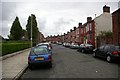
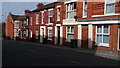
The property market in CH43 4UX is defined by a specific concentration of flats and a mixed tenancy structure. With 34% of residents being homeowners, the area presents a distinct contrast to many post-war council estates where rental rates may exceed 90%. This balance indicates a healthy mix of private renting and ownership, though the latter does not dominate the immediate backyard of every block. The predominant accommodation type is flats, a feature that shapes the density and social dynamics of the 1.7-hectare cluster. You are likely to find self-contained units rather than semi-detached houses or terraced rows within this specific postcode boundary. This housing style suits the median age of 47, as the population skews towards adults and older residents who often prefer lower-maintenance living over detached properties. Potential buyers should note that while areas immediately surrounding CH43 may offer different housing stock, the core postcode focuses on flat living. The market dynamics here reflect a community where security of tenure varies, but the physical environment remains consistent. Understanding this structure helps you compare the costs and stability of purchasing versus renting in this specific Wirral location compared to other parts of Birkenhead.
House Prices in CH43 4UX
Showing 33 properties
| Address | Type | Beds | Baths | Last Sale Price | Last Sale Date | |
|---|---|---|---|---|---|---|
| 8 Park Road South, Birkenhead, CH43 4UX | Semi-detached | 8 | - | £465,000 | Feb 2023 | |
| 18 Park Road South, Birkenhead, CH43 4UX | house | 6 | - | £224,000 | Feb 2013 | |
| 12 Park Road South, Birkenhead, CH43 4UX | Semi-detached | 8 | 2 | £215,000 | Aug 2007 | |
| 22 Park Road South, Birkenhead, CH43 4UX | Semi-detached | - | - | £149,950 | Nov 2003 | |
| Flat 4, 28 Park Road South, Birkenhead, CH43 4UX | Flat | 8 | 4 | - | - | |
| Flat 8, 10 Park Road South, Birkenhead, CH43 4UX | Flat | 16 | 8 | - | - | |
| Flat 3, 8 Park Road South, Birkenhead, CH43 4UX | Flat | - | - | - | - | |
| Flat 4, 8 Park Road South, Birkenhead, CH43 4UX | Flat | - | - | - | - | |
| Flat 2, 8 Park Road South, Birkenhead, CH43 4UX | Flat | - | - | - | - | |
| Flat 1, 8 Park Road South, Birkenhead, CH43 4UX | Flat | - | - | - | - |
Energy Efficiency in CH43 4UX
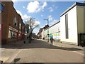
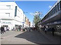
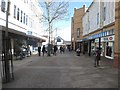
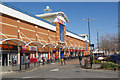
Living in CH43 4UX grants you convenient access to a variety of retail outlets and transport hubs within practical reach. Retail options include Asda Birkenhead, Farmfoods Salisbury, and Lidl Central, providing a mix of hypermarket convenience, fresh produce, and essential groceries. You can shop for weekly necessities and larger purchases without lengthy commutes. For rail travel, Birkenhead Park Railway Station sits closest, followed by Conway Park Railway Station and Birkenhead Central Railway Station. These stations offer direct links to Liverpool, the North West, and the rest of the country. Ferry connectivity is equally strong, with Birkenhead Ferry Terminal, Woodside Birkenhead Ferry Terminal, and Seacombe Ferry Terminal nearby. These terminals allow you to commute to Chester or travel to North Wales by sea. The area is also adjacent to Birkenhead Park, offering a significant green space for walking, jogging, or family picnics. This combination of retail diversity, rail, and ferry access creates a lifestyle that balances suburban quiet with urban connectivity. Residents do not need to venture far for essential services or leisure activities. The proximity to over 15 distinct transport and retail nodes ensures that daily life in CH43 4UX remains efficient and well-connected.
Amenities
Schools
Families considering homes in CH43 4UX have access to a limited number of educational institutions within the immediate vicinity. Park High School operates as a primary school serving young children in the neighbourhood. For secondary education, Birkenhead Park School functions as an academy with an Ofsted rating of satisfactory. This mix of primary and academy provision means you do not have a comprehensive spectrum of tertiary education options right on your doorstep, yet the available choices maintain acceptable standards. The presence of Park High School nearby ensures that younger children can attend local primary education without travel to the town centre. Birkenhead Park School, with its satisfactory rating, provides a secondary option that meets government baseline expectations for curriculum delivery and student care. While the list of schools is short, the selections offer a functional mix for residents with children. You will not find multiple academies or outstanding-rated institutions directly adjacent to CH43, but the existing providers offer stable educational pathways. Prospective parents should consider that the school choice in this specific postcode is constrained by geography, directing older students further afield or to secondary provisions like Birkenhead Park School.
| Rank | School | Type | Entry gender | Ages |
|---|
Explore more schools in this area
Go to Schools tabDemographics
The community in CH43 4UX reflects a mature population with a median age of 47 years. Adults between the ages of 30 and 64 years represent the most common age range within this small residential cluster. This demographic profile suggests a neighbourhood dominated by established residents rather than young families or students seeking temporary housing. Home ownership stands at 34%, meaning a significant proportion of the 1693 residents rent their accommodation. The predominant form of accommodation in this postcode is flats, which aligns with the higher rental percentage and the specific housing stock available. The ethnic composition is predominantly White, consistent with the broader demographic trends of established suburban areas in the Wirral. You will find a community where long-term tenancy or ownership is common, driven by the age structure of the inhabitants. The concentration of adults in this age bracket implies a need for local services tailored to mature households and retirees, although specific data on budget constraints or deprivation levels is not included in the available records. The housing mix prioritises flat living, which may appeal to those seeking low-maintenance properties within a walkable environment.
Household Size
Accommodation Type
Tenure
Ethnic Group
Religion
Household Composition
Age
Household Deprivation
NS-SEC
Explore more demographic insights in this area
Go to Demographics tabPlanning
Planning Constraints
- Flood RiskPremium
- Ramsar Wetland SitesPremium
- Area of Outstanding Natural BeautyPremium
- Protected Nature ReservePremium
- Protected WoodlandPremium