Area Overview for CH41 6NZ
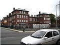
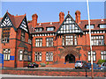
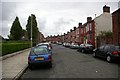
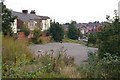
Photos of CH41 6NZ


Area Information
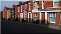
CH41 6NZ is a compact residential postcode in Wirral, England, covering 692 square metres and home to 1,691 residents. Its high population density of 2.4 million people per square kilometre reflects its small, tightly packed character. Situated in the Birkenhead and Tranmere Ward, the area blends urban living with historical roots. Tranmere, part of the Wirral Peninsula, has a legacy of industrial activity and maritime connections, though today it is defined by its residential clusters. The median age of 47 suggests a mature community, with adults aged 30–64 forming the majority. Flats dominate the housing stock, and home ownership is relatively low at 19%, indicating a rental-heavy market. Daily life here is shaped by proximity to transport links, retail, and schools, with a focus on practicality over sprawling suburban sprawl. The area’s small size means amenities are within easy reach, though its density can create a sense of closeness that some may find either comforting or challenging. For buyers, CH41 6NZ offers a snapshot of urban living in a historically rich part of Merseyside.
- Area Type
- Postcode
- Area Size
- 692 m²
- Population
- Not available
- Population Density
- Not available
CH41 6NZ is characterised by a rental-dominated property market, with only 19% of homes owned by residents. This low ownership rate suggests a high proportion of private rentals, which may appeal to those seeking flexibility but could also indicate limited long-term investment opportunities. The accommodation type is predominantly flats, which are well-suited to the area’s compact size and high density. Flats in this postcode are likely to be smaller, with shared walls and communal spaces, making them practical for individuals or couples. For buyers, the small area and limited housing stock mean competition for available properties, particularly in a market where ownership is rare. The focus on flats also means that the area may not cater to larger families or those seeking detached homes. Prospective buyers should consider the rental-centric nature of the market and the potential for limited property choices in this small postcode.
House Prices in CH41 6NZ
Showing 1 properties
| Address | Type | Beds | Baths | Last Sale Price | Last Sale Date | |
|---|---|---|---|---|---|---|
| Halifax, 210 Grange Road, Birkenhead, CH41 6NZ | Retail | - | - | - | - |
Energy Efficiency in CH41 6NZ
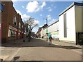
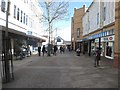
Living in CH41 6NZ offers access to a range of practical amenities within walking or short driving distance. Retail options include five notable venues such as Asda Birkenhead and Farmfoods Salisbury, providing grocery and shopping needs. The area’s transport links are robust, with five railway stations, including Birkenhead Central, offering connections to cities like Liverpool and Chester. Ferry terminals like Birkenhead Ferry Terminal and Seacombe Ferry Terminal provide water-based travel, ideal for commuters or leisure trips. While parks and green spaces are not explicitly mentioned, the proximity to historical sites such as St Catherine’s Church and Tranmere Old Hall adds cultural value. The compact layout ensures that daily life is efficient, with shops, transport, and community hubs all within easy reach.
Amenities
Schools
Residents of CH41 6NZ have access to two notable schools. St Laurence’s Catholic Primary School provides a faith-based education for younger children, while Progress Schools - Wirral, an independent institution, offers a private alternative with an Ofsted rating of ‘good’. The presence of both a state and independent school gives families options, though the independent school’s higher fees may limit accessibility for some. St Laurence’s caters to primary education, which is essential for local families, while Progress Schools may attract those seeking alternative curricula or smaller class sizes. The ‘good’ rating for the independent school suggests it meets quality standards, but the lack of data on state school performance means it is unclear how the primary school compares. Families should consider the proximity of these schools and their alignment with educational priorities when deciding to move to the area.
| Rank | School | Type | Entry gender | Ages |
|---|
Explore more schools in this area
Go to Schools tabDemographics
The population of CH41 6NZ is predominantly adults aged 30–64, with a median age of 47. This suggests a community of middle-aged residents, many of whom may be established professionals or families. Home ownership is low at 19%, meaning most residents are likely to be renters, which can influence the area’s transient nature. The accommodation type is primarily flats, reflecting a housing stock suited to smaller households or those prioritising convenience over space. The predominant ethnic group is White, though specific data on diversity is not provided. The low home ownership rate may indicate a reliance on rental properties, which could impact long-term stability for residents. The age profile suggests a community with a focus on routine and established lifestyles, though the lack of data on deprivation means it is unclear how economic pressures might affect quality of life.
Household Size
Accommodation Type
Tenure
Ethnic Group
Religion
Household Composition
Age
Household Deprivation
NS-SEC
Explore more demographic insights in this area
Go to Demographics tabPlanning
Planning Constraints
- Flood RiskPremium
- Ramsar Wetland SitesPremium
- Area of Outstanding Natural BeautyPremium
- Protected Nature ReservePremium
- Protected WoodlandPremium