Area Overview for Central & West Bank Ward
Photos of Central & West Bank Ward


Area Information
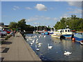
Central & West Bank Ward is a compact district covering just 6.1 square kilometres in England. This small footprint creates a tight-knit environment where daily life moves quickly and distances remain short for most residents. Living in Central & West Bank Ward means navigating a space defined by significant environmental challenges, with high flood risk covering much of the territory. Despite these risks, the area maintains a specific demographic character that distinguishes it from surrounding regions. The ward is not a sprawling suburb but a focused neighbourhood with limited physical space. You will find that your horizon extends little beyond the immediate boundaries of the 6.1 square kilometres, which concentrates both amenities and constraints. This density shapes how people conduct their daily routines, forcing a reliance on local resources and immediate connectivity. Prospective buyers must weigh the compact nature of the ward against the serious safety assessments that define the location. The area does not offer the sprawl of larger boroughs, meaning every development choice carries more weight regarding local conditions. Your understanding of life here must begin with an awareness of these geographical limits and the inherent risks embedded in the landscape.
- Area Type
- District Borough Unitary Ward
- Area Size
- 6.1 km²
- Population
- Not available
- Population Density
- Not available
Demographics
The community in Central & West Bank Ward displays a distinctly older population profile compared to many other English districts. The median age stands at 70 years, indicating that the majority of residents are seniors. You will encounter an age structure that leans heavily towards older demographics, reflecting a retirement-focused settlement. Home ownership remains moderate at 43 per cent, suggesting that a significant portion of households rely on renting while space is at a premium. The data does not specify household composition breakdowns, yet the high median age implies that single-person households or couples without children likely dominate the social fabric. There is no record of predominant ethnic groups or religious affiliations in the available information, meaning the demographic picture relies primarily on age and tenure. A population averaging 70 years old creates a specific dynamic for local services and social interaction. Residents here must adapt to a neighbourhood built for an older demographic, where mobility and leisure activities serve the senior community. This age concentration influences everything from local shop offerings to the pace of community engagement.
Household Size
Accommodation Type
Tenure
Ethnic Group
Religion
Household Composition
Age
Household Deprivation
NS-SEC
Explore more demographic insights in this area
Go to Demographics tabPlanning
Planning Constraints
- Flood RiskPremium
- Ramsar Wetland SitesPremium
- Area of Outstanding Natural BeautyPremium
- Protected Nature ReservePremium
- Protected WoodlandPremium
- Crime RiskPremium