Area Overview for CA5 7PT
Photos of CA5 7PT


Area Information
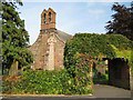
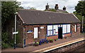
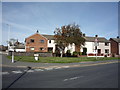
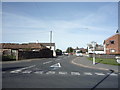
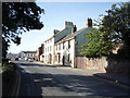
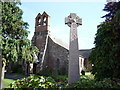
CA5 7PT is a small, rural postcode in Cumbria, England, encompassing the village of Dalston. With a population of 1,696 and a low density of 35 people per square kilometre, it retains a quiet, village-like character. Situated 4 miles south-west of Carlisle, the area is defined by its proximity to the River Caldew and the M6 motorway, offering a blend of rural tranquillity and accessible connectivity. Historically, Dalston was a market town with a thriving agricultural economy, though today it is a peaceful residential cluster with a mix of older homes and modern housing. The village is dotted with farms, a working quarry, and horticultural businesses, reflecting its enduring ties to the land. Residents benefit from nearby rail links to Carlisle and Workington, while the surrounding landscape includes the historic Rose Castle and the Dalston Oil Terminal, a major fuel hub. This postcode is ideal for those seeking a low-density, community-focused lifestyle with a strong sense of local identity and natural surroundings.
- Area Type
- Postcode
- Area Size
- Not available
- Population
- 1696
- Population Density
- 35 people/km²
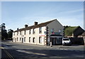
The property market in CA5 7PT is dominated by owner-occupied homes, with 78% of properties owned by their residents. This high ownership rate reflects the area’s appeal to long-term residents and its stable, rural character. The accommodation type is primarily houses, which are more common in low-density areas like Dalston. This suggests a housing stock that includes larger, possibly older properties, some of which may date back to the 19th or early 20th century. The small size of the postcode means the market is limited, with fewer properties available compared to urban areas. Buyers should expect a focus on individual homes rather than apartments or shared housing. The mix of traditional and modern housing, combined with the area’s proximity to natural amenities, makes it attractive to those seeking a rural lifestyle with a strong sense of community.
House Prices in CA5 7PT
No properties found in this postcode.
Energy Efficiency in CA5 7PT
Living in CA5 7PT offers a blend of rural simplicity and practical amenities. Nearby, residents can shop at Co-op Dalston, Spar, and Co-op Morton, providing essentials within walking distance. The village’s character is enhanced by its proximity to the River Caldew, the Dalston Oil Terminal, and the working quarry at Cardewlees, which may host future leisure activities. For recreation, the surrounding landscape includes historic sites like Rose Castle and open countryside. The presence of Dobbies Garden Centre and commercial greenhouses suggests a thriving horticultural sector, adding to the area’s distinctiveness. While dining options are limited to local pubs and cafes, the rural setting offers a peaceful lifestyle. The mix of farms, caravan parks, and private housing creates a community with a strong connection to the land and a low-density, neighbourly atmosphere.
Amenities
Schools
CA5 7PT is served by three schools, each offering distinct educational options. Stoneraise School and Raughton Head CofE School & Nursery are both primary schools with Ofsted ratings of ‘good’, indicating a reliable standard of education for younger children. Lime House School, an independent institution, provides alternative schooling for families seeking private education. The combination of state and independent schools gives residents flexibility in choosing their children’s education. For primary-age children, the ‘good’ Ofsted ratings suggest a focus on quality teaching and resources. However, the absence of secondary schools in the immediate area means families may need to consider commuting to nearby towns like Carlisle for higher education. This mix of school types caters to diverse needs but requires planning for secondary schooling.
| Rank | School | Type | Entry gender | Ages |
|---|
Explore more schools in this area
Go to Schools tabDemographics
The population of CA5 7PT has a median age of 47, with the majority of residents aged between 30 and 64. This suggests a community of established adults, many of whom may be retired or in later career stages. Home ownership is high at 78%, indicating a stable, long-term resident base. The primary accommodation type is houses, reflecting the area’s rural character and lower population density. The predominant ethnic group is White, with no specific data on other demographics provided. The age profile and ownership rates suggest a mature, settled community with limited turnover. For prospective buyers, this implies a neighbourhood with a strong sense of continuity and fewer transient populations. The absence of detailed diversity data means the area’s social composition remains largely unexplored in public records, though the demographic profile aligns with typical rural Cumbrian trends.
Household Size
Accommodation Type
Tenure
Ethnic Group
Religion
Household Composition
Age
Household Deprivation
NS-SEC
Explore more demographic insights in this area
Go to Demographics tabPlanning
Planning Constraints
- Flood RiskPremium
- Ramsar Wetland SitesPremium
- Area of Outstanding Natural BeautyPremium
- Protected Nature ReservePremium
- Protected WoodlandPremium