Area Overview for CA12 4DB
Photos of CA12 4DB

Area Information
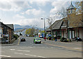
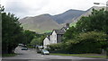
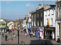
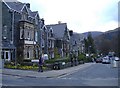
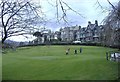
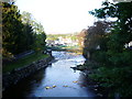
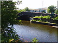
Living in CA12 4DB means being part of a small, tightly knit residential cluster in the Lake District, where the landscape of fells and lakes shapes daily life. This area, covering 7,205 square metres, is home to 1,359 people, giving it a population density of 554 per square kilometre. Its proximity to Keswick, a historic market town, offers a blend of rural tranquillity and accessible amenities. The town’s medieval roots and 700-year-old market charter provide a sense of continuity, while its role as a tourist hub ensures a steady flow of visitors. Residents benefit from proximity to Derwentwater, a key natural attraction, and the legacy of industries like pencil manufacturing. The area’s compact size means most needs are met within walking distance, though its small population reflects a focus on low-density living. For those seeking a quiet, picturesque setting with historical depth, CA12 4DB offers a unique balance of isolation and connection to the surrounding natural and cultural landscape.
- Area Type
- Postcode
- Area Size
- 7205 m²
- Population
- 1359
- Population Density
- 554 people/km²
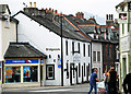
The property market in CA12 4DB is characterised by a 50% home ownership rate, with houses forming the predominant accommodation type. This suggests a small, low-density housing stock that likely includes both older and newer properties, given the area’s historical significance and recent development. The presence of a market town nearby, Keswick, may influence property values, though the small size of CA12 4DB means the market is limited to a handful of homes. Buyers should consider that the area is not a rental hotspot, as only half of properties are owner-occupied, potentially indicating a balance between long-term residents and transient occupants. The compact nature of the area means that properties are likely to be in close proximity to local amenities, which could be a draw for those prioritising convenience. However, the lack of detailed data on property types or price ranges means potential buyers must conduct further local research to assess specific opportunities.
House Prices in CA12 4DB
Showing 1 properties
| Address | Type | Beds | Baths | Last Sale Price | Last Sale Date | |
|---|---|---|---|---|---|---|
| Church Of St John, Cemetery At, Church Lane, Keswick, CA12 4DB | commercial | - | - | - | - |
Energy Efficiency in CA12 4DB
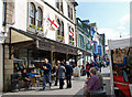
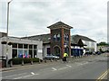
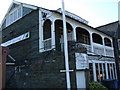
Life in CA12 4DB is shaped by its proximity to Keswick’s amenities, including retail options like Co-op Keswick, Booths Keswick, and Spar, which provide essential shopping. The area’s ferry landings, such as Lingholm Jetty, offer access to water-based activities, enhancing the appeal of living near Derwentwater. While the immediate area has limited leisure facilities, the nearby town of Keswick hosts museums, inns, and recreational spaces, reflecting its role as a tourist hub. The compact size of CA12 4DB means most amenities are within walking distance, fostering a sense of self-sufficiency. However, the absence of detailed data on dining or parks means it is unclear how many local eateries or green spaces exist. The area’s character is defined by its rural setting, with the convenience of nearby services balancing the quiet, low-density lifestyle. Residents benefit from a blend of natural beauty and accessible infrastructure, though the small scale of the area may limit the variety of experiences available.
Amenities
Schools
Residents of CA12 4DB have access to several primary schools, including Keswick School, St John’s CofE First School, and Crosthwaite CofE First School. Notably, Keswick School is also listed as an academy with an outstanding Ofsted rating, indicating high educational standards. The mix of primary schools provides families with options, though the absence of secondary schools in the immediate area may require commuting to nearby towns. The presence of an outstanding-rated academy suggests a strong foundation for early education, which could be a key consideration for families prioritising academic quality. However, the lack of data on school catchment areas or pupil numbers means it is unclear how demand for these schools compares to supply. For parents, the proximity of multiple primary schools within practical reach offers convenience, though secondary education planning would need to factor in travel time to larger centres like Keswick or Penrith.
| Rank | School | Type | Entry gender | Ages |
|---|
Explore more schools in this area
Go to Schools tabDemographics
The community in CA12 4DB is predominantly middle-aged, with a median age of 47 and the largest age group being adults aged 30–64. Home ownership stands at 50%, suggesting a mix of owner-occupied properties and rental units. The area’s accommodation is primarily houses, reflecting a preference for standalone homes over flats or apartments. The predominant ethnic group is White, though specific data on diversity or deprivation is not provided. The population density of 554 per square kilometre indicates a relatively sparse settlement, which may influence the pace of life and community interactions. With no data on income levels or deprivation, it is unclear how economic factors shape quality of life, but the presence of local schools and amenities suggests a basic infrastructure to support residents. The age profile suggests a stable, possibly family-oriented population, though further data would clarify whether the area attracts retirees, professionals, or a mix of both.
Household Size
Accommodation Type
Tenure
Ethnic Group
Religion
Household Composition
Age
Household Deprivation
NS-SEC
Explore more demographic insights in this area
Go to Demographics tabPlanning
Planning Constraints
- Flood RiskPremium
- Ramsar Wetland SitesPremium
- Area of Outstanding Natural BeautyPremium
- Protected Nature ReservePremium
- Protected WoodlandPremium