Area Overview for CA11 0PE
Photos of CA11 0PE


Area Information
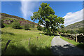
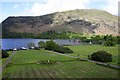
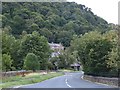
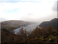
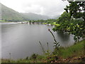
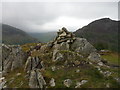
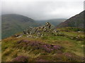
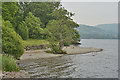
CA11 0PE is a small, rural postcode area in Cumbria, nestled within the Lake District’s Ullswater Valley. Covering just 5.7 hectares, it is home to 1,363 residents, with a population density of 9 people per square kilometre. This sparse settlement reflects its character as a quiet, close-knit village, where the landscape is defined by the surrounding hills and the proximity to Ullswater lake. The area’s history is deeply tied to the Lake District’s heritage, with Patterdale Hall, a historic estate dating to 1624, standing as a local landmark. Daily life here is shaped by the rural environment, with a strong farming community and a legacy of mining activity in nearby Glenridding. The village’s location near Ullswater offers easy access to outdoor pursuits, while its small size ensures a low-key, community-oriented atmosphere. For buyers seeking a peaceful, low-density lifestyle with natural surroundings, CA11 0PE presents a unique blend of historical charm and modern simplicity.
- Area Type
- Postcode
- Area Size
- 5.7 hectares
- Population
- 1363
- Population Density
- 9 people/km²
The property market in CA11 0PE is characterised by a high rate of home ownership (73%) and a predominance of houses, reflecting the area’s rural, low-density nature. This suggests that the housing stock is not primarily geared towards rental or investment properties but rather serves the needs of long-term residents. The small size of the postcode area means that the available housing is limited, and buyers should consider the local character and constraints of the environment. The presence of historic properties, such as those associated with Patterdale Hall, may add to the area’s appeal for those seeking traditional or architecturally distinctive homes. However, the limited scale of the market means that buyers may need to look beyond the immediate postcode for more options, though the surrounding Lake District offers a range of properties with similar rural attributes.
House Prices in CA11 0PE
Showing 28 properties
Energy Efficiency in CA11 0PE
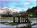
Living in CA11 0PE means embracing a rural lifestyle centred on nature, tradition, and community. The area’s proximity to Ullswater and the Lake District National Park provides ample opportunities for outdoor activities, from walking and boating to wildlife observation. The village itself has a strong historical character, with landmarks such as Patterdale Hall, a 17th-century estate now used for outdoor pursuits and holiday homes. Local amenities include the Patterdale Hotel, a community-owned playing field, and the village church, which contribute to a sense of place. While the area lacks large retail centres or dining options, the nearby ferry terminals connect residents to broader services in towns like Ambleside. The low population density and quiet environment make it ideal for those seeking tranquillity, though it requires a willingness to embrace the limitations of rural living, such as fewer shops and longer travel times for non-essential services.
Amenities
Schools
Residents of CA11 0PE have access to two primary schools: Penruddock Primary School, which holds an Ofsted rating of ‘satisfactory’, and Patterdale CofE Primary School, rated ‘good’. Both institutions serve the local community, offering education for younger children in a rural setting. The presence of two schools provides families with options, though the small population of the area may mean that class sizes are limited. The ‘good’ rating at Patterdale CofE suggests a higher standard of education, which could be a key consideration for families prioritising academic outcomes. However, the lack of secondary schools within the immediate area means that students may need to commute to nearby towns such as Pooley Bridge or Ambleside for further education. This dynamic is common in small rural communities, where local schools cater to primary needs but require broader regional networks for secondary education.
| Rank | School | Type | Entry gender | Ages |
|---|
Explore more schools in this area
Go to Schools tabDemographics
The population of CA11 0PE has a median age of 47, with the majority of residents aged between 30 and 64 years. This suggests a community skewed towards middle-aged adults, many of whom may be long-term residents or connected to the area’s historical industries. Home ownership is high, with 73% of properties occupied by their owners, reflecting a stable, settled population. The accommodation type is predominantly houses, aligning with the rural character of the area. The predominant ethnic group is White, which is typical for small rural communities in northern England. With a population density of 9 people per square kilometre, the area is sparsely populated, offering a sense of space and privacy. This low density, combined with the age profile, implies a community that values quiet living and a connection to the land, though it may lack the vibrancy of more densely populated areas.
Household Size
Accommodation Type
Tenure
Ethnic Group
Religion
Household Composition
Age
Household Deprivation
NS-SEC
Explore more demographic insights in this area
Go to Demographics tabPlanning
Planning Constraints
- Flood RiskPremium
- Ramsar Wetland SitesPremium
- Area of Outstanding Natural BeautyPremium
- Protected Nature ReservePremium
- Protected WoodlandPremium