Area Overview for CA11 0JS
Photos of CA11 0JS


Area Information
Living in CA11 0JS offers a quiet existence within the historic parish of Matterdale in Cumbria. This postcode covers a specific residential cluster spanning 3.4 square kilometres, tailored to a modest population of 1363 people. The density here is exceptionally low at just nine people per square kilometre, ensuring a rural pace far removed from urban congestion. This area forms part of the Civil parish of Matterdale, which historically absorbed settlements like Dockray, Ulcat Row, and Watermillock over centuries. The landscape and administrative history date back to the founding of the church in 1580 and the creation of the ecclesiastical parish in 1742. A large portion of the residents own their homes, reflecting a community established by long-term inhabitants rather than transient commuters. You will find familiar faces and a distinct lack of bustling crowds, which defines daily life in this specific sector of the Eden district. The setting provides a genuine connection to the countryside while remaining administratively linked to the wider region. This snapshot of CA11 0JS represents a stable, low-density living environment where space is abundant and neighbours are likely known to one another.
- Area Type
- Postcode
- Area Size
- 3.4 km²
- Population
- 1363
- Population Density
- 9 people/km²
The property market in CA11 0JS is defined by a strong commitment to private ownership rather than the rental sector. Seventy-three percent of homes in this postcode are owner-occupied, a statistic that signals a deeply entrenched community where most residents buy to stay. The accommodation type is exclusively houses, meaning you will not find flats or converted apartments within this specific 3.4 square kilometre area. This composition suggests a market geared towards families or individuals seeking traditional detached or semi-detached dwellings surrounded by private grounds. The high ownership rate implies that the local housing market operates through sales rather than auctions or short-term lets. Buyers looking at CA11 0JS are entering a space where properties are passed down or purchased by those intending to live there long-term. This contrasts sharply with urban markets where rental shares dominate. The absence of rental properties indicates that the demand here is for secure tenure and the stability that comes with owning freehold land. For those considering homes in CA11 0JS, the expectations should align with buying a permanent residence in a low-density rural zone.
House Prices in CA11 0JS
Showing 8 properties
Energy Efficiency in CA11 0JS
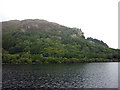
Daily life in CA11 0JS centres on access to the unique transport network found only in the Lake District. Within practical reach of your doorstep, four ferry terminals serve the area, facilitating travel across Ullswater. Notable landmarks include the Ullswater Ferry Terminal, Howtown Ullswater Ferry Landing, and Glenridding Ullswater Ferry Terminal. These venues provide the only direct motor-free transport link across the water, essential for accessing parts of the lake that cars cannot reach. There are no general shops, gyms, or cinemas listed within this immediate postcode boundary, meaning residents rely on walking or driving to reach town services. The lifestyle is defined by these waterways and the historic routes they enable. You might walk from your home in CA11 0JS to a boat landing, then cross the lake to access villages with fuller retail offers. The character of the area is shaped by the rhythm of the boats and the history of湖区 transport rather than modern retail hubs. This reliance on ferry access defines both the convenience and the constraints of living in this specific rural pocket.
Amenities
Schools
Families considering CA11 0JS have access to two primary schools in the immediate vicinity. Penruddock Primary School offers primary education and carries a Satisfactory Ofsted rating. Nearby, Patterdale CofE Primary School also provides primary education and holds a Good Ofsted rating. These institutions are the main educational provisions for children living in this parish, as no secondary schools are listed within this specific data set. The presence of two primary options gives residents some choice within the local community, though both cater to the early years of schooling. The schools are situated close enough to be practical for daily commuting in a rural setting, yet spaced to serve their respective catchments. You will not find academies or special needs colleges listed among the nearest providers for this postcode. The choice remains between these two established institutions, both of which have been assessed by the regulator. For students in the 30 to 64 age group raised in this area, these schools represent the local continuity of education without the disruption of changing boroughs or districts.
| Rank | School | Type | Entry gender | Ages |
|---|
Explore more schools in this area
Go to Schools tabDemographics
The community within CA11 0JS mirrors the stable, settled nature of rural Cumbria. The median age stands at 47 years, indicating that the majority of residents fall into the 30 to 64 years age bracket. This profile suggests families with established roots rather than young professionals seeking rapid career progression. Seventy-three percent of households own their homes, a figure that significantly outpaces national rental markets. This high rate of ownership aligns with the predominant accommodation type, which consists entirely of houses. There are no apartments or shared houses in this dense postcode cluster. The population is predominantly White, consistent with the demographics of much of rural England and Wales. With a home ownership rate of 73% and an average age of 47, the social fabric here relies on long-term stability. You are looking at an area where residents have likely lived for decades, rather than a transient marketplace of short-term tenancies. The housing stock reflects a generation that has grown into their properties, creating a demographic that values quiet and permanence over rapid change.
Household Size
Accommodation Type
Tenure
Ethnic Group
Religion
Household Composition
Age
Household Deprivation
NS-SEC
Explore more demographic insights in this area
Go to Demographics tabPlanning
Planning Constraints
- Flood RiskPremium
- Ramsar Wetland SitesPremium
- Area of Outstanding Natural BeautyPremium
- Protected Nature ReservePremium
- Protected WoodlandPremium