Area Overview for Boothstown & Ellenbrook Ward
Photos of Boothstown & Ellenbrook Ward


Area Information
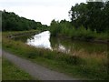
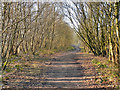
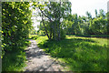
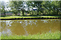
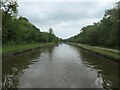
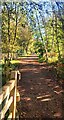
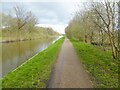
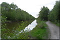
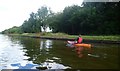
Living in Boothstown & Ellenbrook Ward offers a specific character within Salford, Greater Manchester. You will find yourself in an electoral ward covering 13.6 square kilometres and home to 2,842 people. The landscape is defined by open agricultural land and mature woodland east of Boothstown. This ward borders Tyldesley to the west and Walkden and Little Hulton to the north. Roman history underpins the location, evidenced by a coin hoard from AD 250-275 found near a local quarry in 1947. A Roman road once ran from Keeper Delph across Mort Lane towards Wigan. Booths Hall stands as a notable feature, retaining 17th- and 18th-century additions after earlier alterations in the 1920s. The estate originated from temporary huts near Chat Moss and evolved through ownership by families such as the Worsleys and Charnocks. Modern proximity includes the M60 motorway to the west and the B5211 (Barton Road) near a former quarry junction. The area also sits close to the Liverpool-East Lancashire Road. If you are researching homes in Boothstown & Ellenbrook Ward, you encounter a setting that blends ancient pathways with historic manor grounds. Daily life involves navigating this mix of greenfield sites and established boundaries. A 30-hectare greenfield site of open agricultural land and mature woodland characterises the eastern edge of the ward.
- Area Type
- District Borough Unitary Ward
- Area Size
- 13.6 km²
- Population
- 2842
- Population Density
- 210 people/km²
Demographics
The community profile within Boothstown & Ellenbrook Ward shifts dramatically away from typical family demographics. The median age sits at 70 years, making this an area predominantly populated by older residents. You will find that the household composition and predominant ethnic group data are not detailed in the current records. However, the ownership picture is clear and significant. Home ownership rates stand at 85 per cent. This indicates a market where the vast majority of residences are occupied by their owners rather than tenants. When considering schools near Boothstown & Ellenbrook Ward, you must account for the age profile. With a median age of 70, the immediate vicinity does not suggest a high concentration of young children or teenagers attending school in this specific ward. The accommodation type breakdown is similarly unavailable in the provided figures, preventing a detailed analysis of flat versus house distribution. Despite these gaps, the 85 per cent ownership figure is a dominant fact. This high level of tenure security usually implies long-term residents who have stayed throughout various life stages. The population density is recorded at 210 people per square kilometre, reflecting a relatively low density compared to urban city centres. This spread supports the presence of green spaces alongside the residential areas in Boothstown & Ellenbrook Ward.
Household Size
Accommodation Type
Tenure
Ethnic Group
Religion
Household Composition
Age
Household Deprivation
NS-SEC
Explore more demographic insights in this area
Go to Demographics tabPlanning
Planning Constraints
- Flood RiskPremium
- Ramsar Wetland SitesPremium
- Area of Outstanding Natural BeautyPremium
- Protected Nature ReservePremium
- Protected WoodlandPremium
- Crime RiskPremium