Area Overview for BL9 9UQ
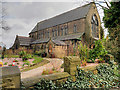
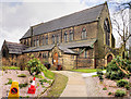
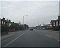
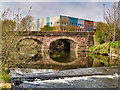
Photos of BL9 9UQ
Area Information
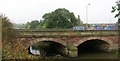
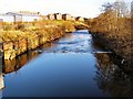
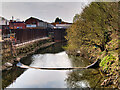
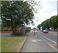
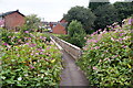
BL9 9UQ is a small residential cluster in England, nestled in the southern reaches of Bury, Greater Manchester. With a population of just 1,734, it is a compact area defined by its semi-detached housing and proximity to the River Irwell. Historically, the district was shaped by industrial and social developments, including the 18th-century Redvales workhouse and the Bury Golf Club, which operated until World War I. Today, the area retains a suburban character typical of post-industrial Lancashire towns, with traditional mill cottages and Radcliffe Road serving as a key thoroughfare. Living here means being part of a tight-knit community with easy access to Bury town centre and surrounding amenities. The postcode’s small size means it is a self-contained microcosm, offering a quiet, residential lifestyle without the density of larger urban areas. Its location near Manchester Road and Tarn Drive places it within reach of both local services and broader transport networks, making it a practical choice for those seeking a balance between seclusion and connectivity.
- Area Type
- Postcode
- Area Size
- Not available
- Population
- 1734
- Population Density
- 1885 people/km²
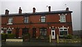
The property market in BL9 9UQ is characterised by high home ownership (75%) and a predominance of houses, primarily semi-detached. This suggests a market skewed toward owner-occupation rather than rental activity, with limited scope for investment in buy-to-let properties. The small size of the area means the housing stock is constrained, and buyers may need to look beyond BL9 9UQ itself to find additional options. The semi-detached nature of the homes, combined with traditional mill cottages near the River Irwell, reflects a mix of architectural styles typical of post-industrial Lancashire. For prospective buyers, this means properties are likely to be family-sized homes with established gardens, appealing to those seeking a settled, low-maintenance lifestyle. However, the limited supply and compact footprint of the area could make competition for properties intense, particularly for those prioritising immediate availability.
House Prices in BL9 9UQ
No properties found in this postcode.
Energy Efficiency in BL9 9UQ
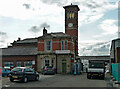
Residents of BL9 9UQ have access to a range of local amenities within practical reach. Retail options include Asda Blackford, Morrisons Daily, and Iceland Bury, providing essential shopping and grocery needs. The area’s transport links are robust, with five metro stops and three rail stations, including Bury Interchange and Clifton Railway Station, facilitating easy travel to Manchester, Bolton, and beyond. While the data does not mention parks or leisure facilities explicitly, the presence of the River Irwell and historical sites like Radcliffe Road suggest opportunities for outdoor activities. The mix of retail, transport, and proximity to Bury’s town centre creates a convenient lifestyle, balancing local convenience with regional connectivity. For families, the area’s mature age profile and semi-detached housing may appeal to those seeking a settled, community-focused environment.
Amenities
Schools
| Rank | School | Type | Entry gender | Ages |
|---|
Explore more schools in this area
Go to Schools tabDemographics
The population of BL9 9UQ is 1,734, with a median age of 47, indicating a community skewed toward adults aged 30–64. This age range suggests a stable, established population, likely comprising professionals, families, and retirees. Home ownership is high at 75%, reflecting a predominantly owner-occupied area, with houses being the primary accommodation type. The predominant ethnic group is White, which aligns with broader demographic trends in Greater Manchester. The absence of specific data on deprivation or diversity metrics means the area’s social composition remains largely unexamined in the provided data. However, the high home ownership rate and mature age profile suggest a low turnover of residents, contributing to a sense of continuity. For buyers, this demographic profile implies a community focused on long-term stability rather than transient populations, with potential implications for local schools, services, and property values.
Household Size
Accommodation Type
Tenure
Ethnic Group
Religion
Household Composition
Age
Household Deprivation
NS-SEC
Explore more demographic insights in this area
Go to Demographics tabPlanning
Planning Constraints
- Flood RiskPremium
- Ramsar Wetland SitesPremium
- Area of Outstanding Natural BeautyPremium
- Protected Nature ReservePremium
- Protected WoodlandPremium