Area Overview for BL9 0LT
Photos of BL9 0LT

Area Information
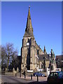
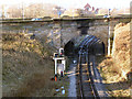
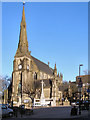
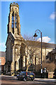
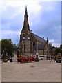
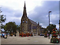
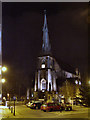
BL9 0LT is a small residential postcode in England, nestled within the Metropolitan Borough of Bury, Greater Manchester. With a population of 2,649, it reflects a tightly knit community centred around historic and modern elements. The area’s character is shaped by its proximity to Bury, a town with roots in Saxon and Roman history, and its connection to the East Lancashire Railway, which brought growth in the 19th century. The postcode lies near Ramsbottom, a locale marked by ancient settlement origins and riverine landscapes. Daily life here is defined by a balance of historical heritage and contemporary infrastructure. Residents benefit from nearby amenities, including retail hubs like Tesco Bury and Asda Bury, as well as rail links to Kearsley and Farnworth stations. The area’s small size means it is a compact, self-contained environment, where the community’s diversity—particularly its Asian population—adds cultural depth to local life. For those considering living in BL9 0LT, the mix of historic charm and practical connectivity offers a distinct contrast to larger urban centres.
- Area Type
- Postcode
- Area Size
- Not available
- Population
- Not available
- Population Density
- Not available
BL9 0LT is primarily a rental market, with only 29% of residents owning their homes. The accommodation type is predominantly houses, which is unusual for a postcode of this size, suggesting a mix of older, standalone properties rather than high-density housing. This configuration may limit the availability of flats or apartments, making the area more appealing to buyers seeking family homes or those preferring single-unit properties. The low home ownership rate indicates that the local property market is likely competitive, with limited stock for purchase. For buyers, this means the area may not be ideal for those seeking investment opportunities in rental properties, but it could be suitable for those prioritising ownership in a residential setting. The presence of houses also implies a quieter, more private lifestyle compared to urban areas with higher population density.
House Prices in BL9 0LT
No properties found in this postcode.
Energy Efficiency in BL9 0LT
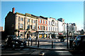
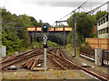
The lifestyle in BL9 0LT is shaped by its proximity to retail, transport, and community hubs. Nearby amenities include five retail locations such as Tesco Bury and Asda Bury, offering everyday shopping convenience. The area’s five metro stops and three railway stations—Kearsley, Hall i’ th’ Wood, and Farnworth—provide easy access to Bury and beyond, supporting both local and regional travel. While parks and leisure facilities are not explicitly listed, the area’s historical landmarks, such as Peel Tower and Bury Castle, suggest opportunities for cultural and outdoor activities. The presence of multiple retail and transport options means daily life is practical and accessible, with minimal need to travel far for essentials. The mix of historic sites and modern infrastructure creates a balanced environment, where residents can enjoy both heritage and convenience.
Amenities
Schools
BL9 0LT is served by several primary schools, including St Thomas Church of England Primary School, Holy Trinity Primary School, and St Marie’s Roman Catholic Primary School, Bury. Three of these schools—St Thomas, Holy Trinity, and St Marie’s—have received a ‘good’ Ofsted rating, indicating a strong standard of education for younger children. The concentration of primary schools suggests that the area is well-suited for families with young children, offering multiple options for schooling. While no secondary schools are listed, the proximity to Bury town may provide access to broader educational facilities. The presence of multiple schools with positive ratings is a key consideration for families prioritising quality education. The mix of church-affiliated and state-run schools also reflects the area’s cultural and religious diversity.
| Rank | School | Type | Entry gender | Ages |
|---|
Explore more schools in this area
Go to Schools tabDemographics
The median age in BL9 0LT is 47, with the most common age range being adults aged 30–64. This suggests a mature, settled population, likely with established careers and families. Home ownership stands at 29%, indicating that the majority of residents are renters, which may reflect the area’s status as a rental-focused postcode. The predominant accommodation type is houses, rather than flats or apartments, which aligns with the traditional suburban character of the region. The area’s predominant ethnic group is Asian_total, contributing to a culturally diverse community. This demographic profile implies a stable, family-oriented environment where older residents and working-age adults form the core of the population. The relatively low home ownership rate may also suggest a reliance on local rental markets, which could influence property dynamics and affordability.
Household Size
Accommodation Type
Tenure
Ethnic Group
Religion
Household Composition
Age
Household Deprivation
NS-SEC
Explore more demographic insights in this area
Go to Demographics tabPlanning
Planning Constraints
- Flood RiskPremium
- Ramsar Wetland SitesPremium
- Area of Outstanding Natural BeautyPremium
- Protected Nature ReservePremium
- Protected WoodlandPremium