Area Overview for BL4 8EY
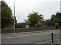
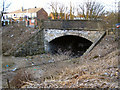
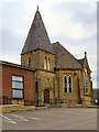
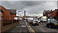
Photos of BL4 8EY
Area Information
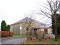
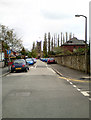
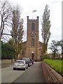
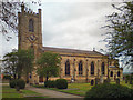
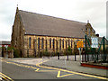
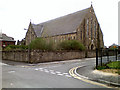
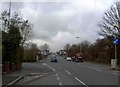
BL4 8EY lies within the Farnworth area of Bolton, a historically industrial region in Greater Manchester. This small postcode covers just 344 m², housing 1,506 residents in a densely populated cluster. The area is defined by its proximity to Bolton town centre, situated three miles to the north-west, and its location near the Bolton and Manchester railway line. The Rivers Irwell and Croal flow through the district, a legacy of its 19th-century industrial past, which included coal mines, cotton mills, and iron foundries. Today, the area retains a distinct character with Central Park, opened in 1864, and St John’s Parish Church, consecrated in 1826, offering green space and heritage. Residents benefit from nearby rail links, retail outlets, and a range of schools. The median age of 47 suggests a mature population, with many residents in their 30s to 60s, creating a community rooted in stability and local ties.
- Area Type
- Postcode
- Area Size
- 344 m²
- Population
- Not available
- Population Density
- Not available
BL4 8EY is a small area with a home ownership rate of 31%, indicating that the majority of properties are rented. The accommodation type is primarily houses, which is unusual for a densely populated postcode, suggesting a mix of older, possibly larger homes. This low ownership rate may reflect the area’s history as a working-class community with limited property investment. For buyers, the compact size of the area means limited housing stock, but proximity to transport links and amenities could make it attractive for those seeking affordability. However, the high population density may limit availability, and the predominance of rental properties could indicate a transient population. Buyers should consider the area’s practical advantages, such as access to schools and rail networks, alongside its challenges.
House Prices in BL4 8EY
No properties found in this postcode.
Energy Efficiency in BL4 8EY
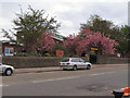
Residents of BL4 8EY have access to a mix of retail, leisure, and green spaces. Nearby shops include Heron Moses, Iceland Farnworth, and Asda Farnworth, offering everyday essentials. The area’s rail and metro links connect to larger towns, while Central Park and Crompton Lodges provide recreational space for walking and picnicking. St John’s Parish Church and Royal Bolton Hospital add historical and healthcare significance. The proximity to Bolton and Manchester ensures cultural and employment opportunities, though the area’s small size means amenities are tightly clustered. This compactness fosters a sense of community, with local shops and parks serving as focal points for daily life.
Amenities
Schools
Residents of BL4 8EY have access to a range of educational institutions. Bridgewater Nursery School provides early years education, while Queen Street Primary School and St Gregory’s RC Primary School, Farnworth, Bolton, cater to primary-age children. Compass Centre South offers additional educational or community services, and TLG Bolton is an independent school providing alternative schooling options. The presence of both state and independent schools gives families flexibility in choosing education. However, no Ofsted ratings are provided, so parents may need to investigate further. The mix of school types suggests a community that values both public and private education, though the area’s small size may limit specialist facilities.
| Rank | School | Type | Entry gender | Ages |
|---|
Explore more schools in this area
Go to Schools tabDemographics
The population of BL4 8EY is 1,506, with a median age of 47, indicating a predominantly middle-aged demographic. The most common age range is 30–64 years, reflecting a community of working-age adults and families. Home ownership in the area is low at 31%, suggesting a higher proportion of rental properties and possibly younger or transient residents. The accommodation type is primarily houses, though the small area size and high population density of 4,384,164 people per km² imply a mix of terraced or semi-detached homes. The predominant ethnic group is White, with no specific data on other groups. The low home ownership rate may affect community stability, while the age profile suggests a population focused on employment and family life.
Household Size
Accommodation Type
Tenure
Ethnic Group
Religion
Household Composition
Age
Household Deprivation
NS-SEC
Explore more demographic insights in this area
Go to Demographics tabPlanning
Planning Constraints
- Flood RiskPremium
- Ramsar Wetland SitesPremium
- Area of Outstanding Natural BeautyPremium
- Protected Nature ReservePremium
- Protected WoodlandPremium