Area Overview for BL4 7AD
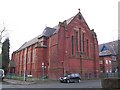
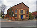
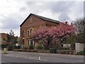
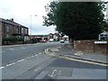
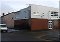
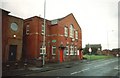
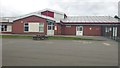
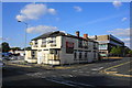
Photos of BL4 7AD
Area Information
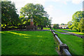
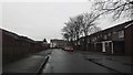
BL4 7AD is a small residential postcode in the Farnworth area of Bolton, Greater Manchester. Covering 5,131 square metres, it is densely populated, with 1,506 residents living at a density of 293,530 people per square kilometre. This compact area lies near the Bolton and Manchester railway line, with the Rivers Irwell and Croal flowing nearby. Historically part of the Bolton Poor Law Union and later a municipal borough until 1974, the area reflects a legacy of industrial activity, including coal mining, cotton mills, and iron foundries. Today, it is a quiet residential cluster with proximity to Central Park, opened in 1864, and St John’s parish church, consecrated in 1826. Daily life here is shaped by its proximity to rail networks, local shops, and community amenities. The area’s compact size means residents are close to essential services, though its density may influence the pace of life. For those seeking a mix of historical character and modern convenience, BL4 7AD offers a distinct blend of heritage and practicality.
- Area Type
- Postcode
- Area Size
- 5131 m²
- Population
- Not available
- Population Density
- Not available
The property market in BL4 7AD is characterised by a 31% home ownership rate, with houses being the primary accommodation type. This suggests a mix of owner-occupied and rental properties, though the low home ownership percentage indicates a rental market may dominate. Given the area’s small size and high population density, housing stock is likely limited to smaller, older properties, possibly semi-detached or terraced homes. For buyers, this means competition for available properties and potential challenges in securing a purchase. The high density may also mean limited scope for new developments, making the existing stock highly sought after. Prospective buyers should consider the area’s compact nature and proximity to amenities, though the rental market’s prevalence may affect long-term investment potential.
House Prices in BL4 7AD
No properties found in this postcode.
Energy Efficiency in BL4 7AD
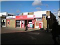
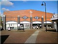
BL4 7AD offers a range of amenities within practical reach. Local shops include Asda Farnworth, Heron Moses, and Lidl Moses, providing everyday essentials. The area’s rail network connects to Farnworth, Moses Gate, and Kearsley stations, facilitating access to larger towns and cities. Nearby, Central Park—a 19th-century green space—offers recreational opportunities, while historical sites like St John’s parish church and Crompton Lodges add cultural value. The presence of an airport nearby and multiple retail outlets suggests a balance of convenience and community character. For residents, daily life combines practicality with access to green spaces and historical landmarks, though the area’s density may limit larger leisure facilities.
Amenities
Schools
Residents of BL4 7AD have access to a range of educational institutions, including Bridgewater Nursery School, Queen Street Primary School, and St Gregory’s RC Primary School in Farnworth. Independent schools such as TLG Bolton are also nearby, offering alternative educational options. The presence of both state and independent schools provides families with choices, though the data does not include Ofsted ratings for these institutions. The mix of nursery, primary, and independent schools suggests a well-rounded educational landscape, catering to different needs and preferences. However, the lack of secondary schools in the immediate area may require families to consider commuting options for older children.
| Rank | School | Type | Entry gender | Ages |
|---|
Explore more schools in this area
Go to Schools tabDemographics
The population of BL4 7AD has a median age of 47, with the majority of residents falling within the 30-64 age range. This suggests a community skewed towards middle-aged adults, likely including families and professionals. Home ownership in the area is relatively low at 31%, indicating a significant proportion of residents may be renting. The predominant accommodation type is houses, which is uncommon in high-density urban areas, suggesting a mix of semi-detached or terraced properties. The predominant ethnic group is White, with no specific data provided on other demographics. The low home ownership rate and age profile may reflect a transient population or a focus on rental properties. For quality of life, this demographic structure implies a stable but not highly diverse community, with potential implications for local services and social dynamics.
Household Size
Accommodation Type
Tenure
Ethnic Group
Religion
Household Composition
Age
Household Deprivation
NS-SEC
Explore more demographic insights in this area
Go to Demographics tabPlanning
Planning Constraints
- Flood RiskPremium
- Ramsar Wetland SitesPremium
- Area of Outstanding Natural BeautyPremium
- Protected Nature ReservePremium
- Protected WoodlandPremium