Area Overview for BL2 5SG
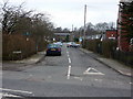
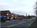
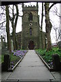
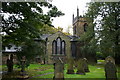
Photos of BL2 5SG

Area Information
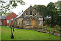
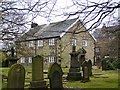
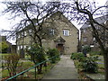
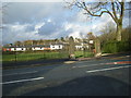
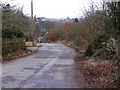
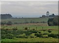
Living in BL2 5SG means residing within a specific residential cluster of Radcliffe North and Ainsworth Ward in Greater Manchester. This small area covers just over four thousand square metres and holds a population of 1,409 people. You are situated in the Irwell Valley approximately 240 metres above sea level, positioned equidistantly between the towns of Bury and Bolton along the B6196 road. The location sits on Carboniferous sandstone geology and forms part of the historic parish of Radcliffe. Ainsworth Village Conservation Area is a designated feature nearby, established in 1973, which reflects the local history of linear farming and later industrial expansion tied to stone quarrying and cotton. Daily life here is shaped by proximity to historical landmarks and the quiet residential nature of the postcodes in this ward. The village expanded during the 19th century due to local industry, yet the modern residential feel remains stable. When you look around this postcode, you see a community settled near the Manchester Bolton and Bury Canal, which originally reached Radcliffe in 1796. Your surroundings blend historical significance with practical access to major transport routes like the turnpikes developed from 1821 onwards.
- Area Type
- Postcode
- Area Size
- 4007 m²
- Population
- 1409
- Population Density
- 405 people/km²
The property market in BL2 5SG is characterised by a heavily owner-occupied landscape, where 86 per cent of households own their homes. Houses represent the primary accommodation type, meaning you will encounter detached or semi-detached properties rather than flats or apartment blocks. This concentration of home ownership suggests a move-up or permanent move-in market rather than a high-volume rental sector. Buyers looking at this small postcode area are addressing a niche segment of the Greater Manchester housing market defined by its historical estates and village character. The housing stock reflects the area's development during the 19th century, when industrial activity drove expansion along the B6196 road. While specific recent price data or sales volumes are not included in the current information, the high ownership percentage indicates strong resident investment in the local real estate. Prospective buyers should note that the area comprises a specific residential cluster of less than half a hectare, which limits the total inventory available at any one time. The dominance of houses over other dwellings means the selling price trends will be heavily influenced by the condition and size of individual family homes in the Ainsworth Conservation Area. Investors seeking rental yields may find this area less dynamic than student hubs, but it suits those seeking long-term stability and property equity.
House Prices in BL2 5SG
No properties found in this postcode.
Energy Efficiency in BL2 5SG
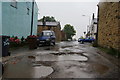
Your lifestyle in BL2 5SG is defined by proximity to several retail and transport hubs within practical reach. You have five retail options nearby, including Aldi Breightmet, Iceland Bolton, and Co-op Mile, providing access to grocers and supermarkets without needing to travel far. For getting around, five railway stations serve the wider network, allowing quick access to Hall in the Wood, Bromley Cross, and Moses Gate. The regional metro also offers five connection points, including Radcliffe and Bury Bolton Street, integrating you into the Greater Manchester transport spine. This connectivity lets you enjoy the quiet of a village like Ainsworth while maintaining easy access to city amenities. The area's history of stone quarrying and cotton spinning means local walks often pass former industrial sites, now part of the conservative landscape of the Ainsworth Village Conservation Area designated in 1973. You can drive the B6196 east-west to reach Bury and Bolton, which are central to your daily errands. The nearest amenities balance convenience with the quiet residential character of the postcode. Residents benefit from a small footprint of 4,007 square metres, meaning your neighbourhood is close-knit but not isolated from major services.
Amenities
Schools
There is one primary school identified in the immediate vicinity of BL2 5SG. Christ Church Ainsworth Church of England Primary School serves the local community with a maintained Ofsted rating of good. This rating indicates that the school meets the expected standards for education and care provided to children in the local area. There are no secondary schools or other educational institutions listed within the provided data for this specific postcode. Families with young children will rely on this single primary option before looking further into the wider Bolton or Bury catchment areas for secondary education. The presence of a church school aligns with the historic and community-focused nature of Ainsworth Village. You must consider travel distances to the nearest other options as they are not detailed in the current dataset. For prospective homebuyers, the availability of a good-rated primary school is a significant positive factor when evaluating this residential cluster. The lack of listed secondary schools in the immediate data implies that living in BL2 5SG typically involves a commute or bus journey to larger towns for older pupils.
| Rank | School | Type | Entry gender | Ages |
|---|
Explore more schools in this area
Go to Schools tabDemographics
The community in BL2 5SG is dominated by older residents, with a median age of 47 years. Most adults in this neighbourhood fall within the 30 to 64 years age range, indicating a stable and established population rather than a transient one. Home ownership is high at 86 per cent, suggesting a strong sense of permanence among local residents. Houses are the predominant form of accommodation, reflecting the traditional character of Ainsworth and its surrounding areas. The predominant ethnic group in this specific area is White, consistent with the wider demographic profile of the Greater Manchester region while maintaining local distinctiveness. This high rate of ownership correlates with the area's history of stone quarrying and cotton industries from the 19th century, where families built lasting roots in the village. You will find that most households have lived in their properties for extended periods, contributing to a low turnover environment. There are no significant data gaps regarding deprivation in the immediate source text, but the high ownership figure implies financial stability within the household structures. The population density of 405 people per square kilometre indicates a moderately spread out living environment, typical for semi-rural villages on the edge of greater urban centres.
Household Size
Accommodation Type
Tenure
Ethnic Group
Religion
Household Composition
Age
Household Deprivation
NS-SEC
Explore more demographic insights in this area
Go to Demographics tabPlanning
Planning Constraints
- Flood RiskPremium
- Ramsar Wetland SitesPremium
- Area of Outstanding Natural BeautyPremium
- Protected Nature ReservePremium
- Protected WoodlandPremium