Area Overview for BL1 6SR
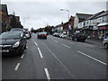
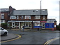
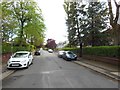
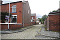
Photos of BL1 6SR


Area Information
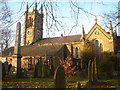
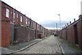
BL1 6SR is a small residential postcode area in Bolton, Greater Manchester, home to 1,633 people. Nestled within Smithills Ward, it is defined by its historical roots, including the nearby Smithills Hall, a Grade I listed manor house dating back to the 14th century. The area’s compact size means it is a quiet, close-knit community, with homes predominantly in the form of detached or semi-detached houses. Daily life here is shaped by its proximity to local amenities, including multiple retail outlets and rail stations. The area’s character is steeped in history, with the moorland landscape and medieval architecture offering a contrast to modern convenience. For those seeking a blend of heritage and practicality, BL1 6SR provides access to essential services within walking or short driving distance. The population, skewed toward adults aged 30–64, suggests a stable, family-oriented demographic. Living here means balancing the tranquillity of a small postcode with the connectivity of nearby towns and transport networks.
- Area Type
- Postcode
- Area Size
- Not available
- Population
- 1633
- Population Density
- 7072 people/km²
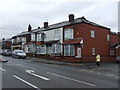
BL1 6SR is a predominantly owner-occupied area, with 78% of homes owned by their residents rather than rented. The housing stock is composed almost entirely of houses, which is typical for smaller, residential postcode areas in England. This suggests a low-rise, suburban character with limited high-density development. The small size of the postcode means the property market is likely limited to a handful of homes, with little variation in types or sizes. For buyers, this could mean a niche market with limited competition but potentially higher prices due to scarcity. The absence of flats or apartments also means the area may appeal more to those seeking traditional family homes. However, the lack of detailed data on property prices or recent transactions makes it difficult to assess market trends. Prospective buyers should consider the area’s proximity to transport links and amenities when evaluating its value.
House Prices in BL1 6SR
No properties found in this postcode.
Energy Efficiency in BL1 6SR
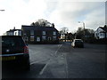
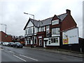
Residents of BL1 6SR have access to five retail outlets, including Morrisons Halliwell and Farmfoods Halliwell, offering everyday shopping needs. The area’s rail network, with stations such as Lostock and Bolton, provides easy access to nearby towns and cities, enhancing connectivity for work, leisure, and social activities. While there are no specific parks or leisure facilities listed in the data, the proximity to rail stations suggests opportunities for outdoor activities in surrounding areas. The presence of a metro station at Radcliffe adds to the area’s transport options, though it requires a short journey. The lifestyle here is characterised by convenience and practicality, with essential services within reach. For those who prioritise ease of access to shopping and transport, BL1 6SR offers a straightforward, functional environment.
Amenities
Schools
The nearest school to BL1 6SR is Church Road Primary School, which holds an Ofsted rating of ‘good’. This institution serves the local community, offering education for younger children in the area. While no secondary schools are listed in the data, the presence of a primary school with a positive rating is a key consideration for families. The school’s rating suggests a satisfactory standard of education, though parents may need to look further afield for secondary options. The absence of additional schools in the immediate vicinity means families should plan for commuting to nearby towns for higher education. For those prioritising proximity to schools, Church Road Primary provides a reliable foundation, but the overall school landscape in BL1 6SR remains limited.
| Rank | School | Type | Entry gender | Ages |
|---|
Explore more schools in this area
Go to Schools tabDemographics
The population of BL1 6SR has a median age of 47, with the majority of residents falling within the 30–64 age range. This indicates a community dominated by working-age adults, many of whom are likely to be homeowners. Home ownership here is exceptionally high at 78%, reflecting a preference for private residence over rental properties. The predominant accommodation type is houses, suggesting a lack of high-density housing or flats. The ethnic composition is predominantly White, though no further breakdown is provided. The absence of specific data on deprivation or diversity means the area’s social dynamics remain largely unexplored in the available records. For residents, this demographic profile implies a mature, settled population with established ties to the local area. The age range also suggests a balance between middle-aged professionals and families, though the lack of younger residents may influence local services and amenities.
Household Size
Accommodation Type
Tenure
Ethnic Group
Religion
Household Composition
Age
Household Deprivation
NS-SEC
Explore more demographic insights in this area
Go to Demographics tabPlanning
Planning Constraints
- Flood RiskPremium
- Ramsar Wetland SitesPremium
- Area of Outstanding Natural BeautyPremium
- Protected Nature ReservePremium
- Protected WoodlandPremium