Area Overview for Beeston
Photos of Beeston
Area Information
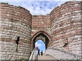
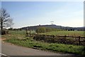
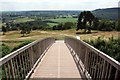
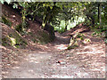
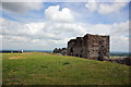
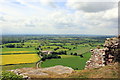
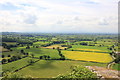
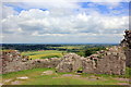
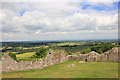
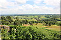
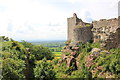
Living in Beeston means inhabiting a small civil parish defined by its deep historic roots and rural setting. This village lies within the unitary authority of Cheshire West and Chester, positioned approximately six miles south-east of Chester and near the Shropshire Union Canal. You are surrounded by an area spanning just eight square kilometres, offering a compact community environment without the constraints of larger towns. The locality is anchored by Beeston Castle, a 13th-century ruin perched on a sandstone crag that manages to captivate visitors with views across eight counties. This landmark sits within a woodland park that also hosts a recreated Bronze Age roundhouse, adding layers of educational interest to your daily surroundings. The district's identity is firmly rooted in its long past, having been listed in the Domesday Book of 1086 and associated with figures such as Sir George Beeston who fought in the Spanish Armada. You can choose from homes in Beeston that stand near this heritage site or explore the immediate neighbourhoods defined by the parish boundaries. For those interested in a quieter pace of life close to significant historical assets, this parish offers a distinct alternative to more densely populated urban centres.
- Area Type
- Parish
- Area Size
- 8.0 km²
- Population
- Not available
- Population Density
- Not available
Demographics
The community living in Beeston presents a clear profile centred on an older population. The median age reaches seventy years, indicating that the most common age range extends well into later life. This demographic reality aligns with a high level of stability, as seventy-six per cent of households show home ownership. This figure stands in sharp contrast to many younger urban areas where renting remains the primary tenure method. You will find that the majority of residents have established a permanent foothold in the locality, which contributes to a established social fabric. Accommodation types reflect this tenure status, with properties likely favouring long-term occupancy over transient holding. The area does not show specific data regarding predominant ethnic groups or religious composition in the available records, so you should expect a community makeup consistent with typical rural Cheshire demographics without assumed diversity claims. The low median age also suggests that you may encounter fewer families with young children compared to commuter belts near major employment hubs. Instead, your neighbours are likely to be retirees or older couples who have chosen to stay in this parish rather than move away due to rising living costs or healthcare access issues.
Household Size
Accommodation Type
Tenure
Ethnic Group
Religion
Household Composition
Age
Household Deprivation
NS-SEC
Explore more demographic insights in this area
Go to Demographics tabPlanning
Planning Constraints
- Flood RiskPremium
- Ramsar Wetland SitesPremium
- Area of Outstanding Natural BeautyPremium
- Protected Nature ReservePremium
- Protected WoodlandPremium
- Crime RiskPremium