Area Overview for BB9 8AJ
Photos of BB9 8AJ

Area Information
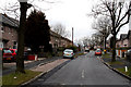
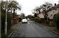
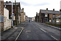
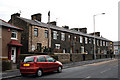
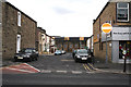
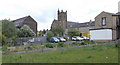
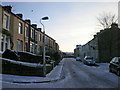
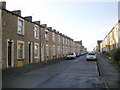
Living in BB9 8AJ means inhabiting a compact, densely populated residential cluster nestled in the historic town of Nelson, Lancashire. This postcode area, spanning just 2.5 hectares, is home to 1,970 residents, translating to a population density of 78,839 people per square kilometre. The area’s character is shaped by its 19th-century origins, driven by the East Lancashire Railway and the Leeds-Liverpool Canal, which spurred development around the Nelson Inn. Today, BB9 8AJ is a small, tight-knit community with a median age of 47, dominated by adults aged 30–64. Daily life here is defined by proximity to local amenities, historic architecture, and a mix of retail and transport options. While the area’s density may feel intimate, it reflects a long-standing tradition of community living. The presence of 56% owner-occupied homes, primarily houses, suggests a stable, family-oriented demographic. For those seeking a blend of historical charm and modern convenience, BB9 8AJ offers a snapshot of Nelson’s industrial past and its enduring residential appeal.
- Area Type
- Postcode
- Area Size
- 2.5 hectares
- Population
- 1970
- Population Density
- 3941 people/km²
The property market in BB9 8AJ is characterised by a 56% home ownership rate, with houses forming the predominant accommodation type. This suggests a residential area where family homes are in demand, though the small area size (2.5 hectares) limits the availability of properties. Given the compact nature of the postcode, the housing stock is likely to be limited, making the market competitive for buyers. The high proportion of owner-occupied homes indicates a stable demand for long-term residency rather than a transient rental market. However, the absence of detailed data on property prices or availability means buyers should consider the area’s proximity to amenities and transport as key factors. For those seeking a home in BB9 8AJ, the focus would be on securing a house in a tightly woven community, where the density of residents may influence both property values and the character of the neighbourhood.
House Prices in BB9 8AJ
No properties found in this postcode.
Energy Efficiency in BB9 8AJ
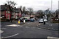
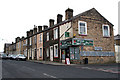
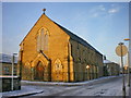
The lifestyle in BB9 8AJ is shaped by its proximity to essential amenities and historic infrastructure. Within practical reach are five retail venues, including Farmfoods Marsden, Spar, and Spar Netherfield, offering daily necessities and convenience for residents. The rail network, with five nearby stations, provides easy access to commuting and regional travel. While the area lacks detailed data on parks or leisure facilities, its historical core—centred on Manchester Road, Scotland Road, and Market Street—features 19th-century shops and commercial premises, adding to its character. The presence of Walverden Mill, a relic of the textile industry, and the town hall (opened 1881) reflects Nelson’s industrial heritage. For daily life, the combination of retail, rail, and historic architecture creates a blend of practicality and tradition. Residents benefit from a compact environment where amenities are close, though the absence of newer recreational facilities may require venturing slightly beyond the postcode for leisure options.
Amenities
Schools
Residents of BB9 8AJ have access to three schools within practical reach: Nelson Walton High School, a primary school; Pendle Vale College, also a primary school with a good Ofsted rating; and Pendle Community High School & College, a special needs institution. The presence of both primary and special educational facilities offers families a range of options, from early education to tailored support for students with specific needs. The good Ofsted rating at Pendle Vale College highlights a reliable standard of teaching, which is reassuring for parents. However, the absence of secondary schools in the immediate area may require families to consider commuting to nearby towns for secondary education. The mix of school types reflects a commitment to inclusive education, though the lack of detailed performance data means prospective buyers should investigate further to assess the quality of local schooling for their specific needs.
| Rank | School | Type | Entry gender | Ages |
|---|
Explore more schools in this area
Go to Schools tabDemographics
The community in BB9 8AJ is predominantly composed of adults aged 30–64, with a median age of 47. This suggests a mature, established population, likely with long-term ties to the area. Home ownership stands at 56%, indicating a mix of owner-occupied properties and rental units. The accommodation type is primarily houses, reflecting a residential profile focused on family homes rather than flats or apartments. The predominant ethnic group is White, though the data does not specify further diversity metrics. The high population density of 78,839 people per square kilometre, combined with the area’s small size, implies a closely knit community where social interactions are frequent. While no specific deprivation data is provided, the age profile and home ownership rate suggest a stable, middle-aged population with established careers and family structures. This demographic may value proximity to local services, schools, and transport links, which are all within practical reach in Nelson.
Household Size
Accommodation Type
Tenure
Ethnic Group
Religion
Household Composition
Age
Household Deprivation
NS-SEC
Explore more demographic insights in this area
Go to Demographics tabPlanning
Planning Constraints
- Flood RiskPremium
- Ramsar Wetland SitesPremium
- Area of Outstanding Natural BeautyPremium
- Protected Nature ReservePremium
- Protected WoodlandPremium