Area Overview for BB5 6GH
Photos of BB5 6GH

Area Information
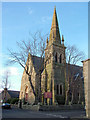
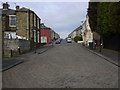
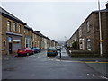
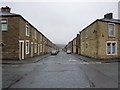
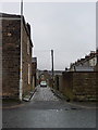
BB5 6GH is a small residential postcode area in the Hyndburn district of Lancashire, England, home to 1,519 people in a compact cluster. With a population density of 1,083 people per square kilometre, it reflects a tightly knit community. The area has historical roots as a township in the ancient parish of Whalley, evolving through industrial growth in the 19th century. Today, it balances heritage with modern living, offering proximity to rail networks and local amenities. Residents here are predominantly adults aged 30–64, with a median age of 47, suggesting a mature, settled population. The area’s character is shaped by its industrial past—once a hub for cotton mills and coal mining—now reflected in its quiet residential streets and preserved historical sites like Huncoat Hall. Daily life is influenced by its connectivity: rail links to Accrington and Rawtenstall provide easy access to nearby towns, while local shops and services cater to immediate needs. For those seeking a mix of tradition and practicality, BB5 6GH offers a snapshot of northern England’s evolving rural-urban landscape.
- Area Type
- Postcode
- Area Size
- Not available
- Population
- 1519
- Population Density
- 1083 people/km²
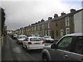
The property market in BB5 6GH is characterised by high home ownership—85% of residents live in owner-occupied homes—suggesting a stable, long-term community. The area is predominantly composed of houses, rather than flats or apartments, which is typical of smaller, semi-rural postcode areas in Lancashire. This housing stock likely includes family homes, reflecting the age profile of the population, which skews towards middle-aged adults. Given the small size of the area and its limited population, the housing market may be relatively niche, with limited scope for new developments. Buyers should consider that the area’s compact nature means competition for properties could be strong, particularly for homes with garden space or proximity to local amenities. The focus on owner-occupation also implies that rental properties are less common, potentially reducing availability for renters. For those seeking a quiet, established residential area with a focus on traditional housing, BB5 6GH offers a distinct alternative to larger urban centres.
House Prices in BB5 6GH
No properties found in this postcode.
Energy Efficiency in BB5 6GH
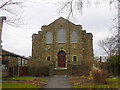
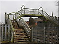
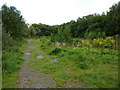
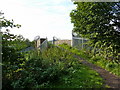
Living in BB5 6GH offers a blend of practical convenience and small-town character. Nearby, five retail outlets—including Spar, Iceland Accrington, and Aldi Milnshaw—provide everyday shopping needs, while rail stations like Accrington and Huncoat connect residents to broader networks. The area’s historical roots are evident in sites like Huncoat Hall and the preserved Peace Garden, offering quiet spaces for reflection. A recreation ground, extended in 1930, and the 1864 cemetery add to the local sense of continuity. While the area lacks large leisure facilities, its proximity to Rawtenstall Metro and nearby towns ensures access to more extensive amenities. The mix of local shops, rail links, and historical sites creates a lifestyle that balances simplicity with accessibility, ideal for those seeking a settled, community-focused environment without sacrificing connectivity.
Amenities
Schools
| Rank | School | Type | Entry gender | Ages |
|---|
Explore more schools in this area
Go to Schools tabDemographics
The community in BB5 6GH is predominantly composed of adults aged 30–64, with a median age of 47. This suggests a population largely focused on middle-aged households, many of whom are likely to be in their prime working years. Home ownership is high, with 85% of residents living in owner-occupied properties, indicating a stable and long-term demographic. The area is primarily composed of houses, rather than flats or apartments, which aligns with the typical housing stock in rural and semi-rural Lancashire. The predominant ethnic group is White, reflecting the broader demographic trends in the region. With a population density of 1,083 people per square kilometre, the area is moderately populated, allowing for a balance between community interaction and personal space. The absence of specific data on deprivation or diversity means the community’s socioeconomic profile remains largely defined by its age and ownership patterns, suggesting a focus on family-oriented, settled living.
Household Size
Accommodation Type
Tenure
Ethnic Group
Religion
Household Composition
Age
Household Deprivation
NS-SEC
Explore more demographic insights in this area
Go to Demographics tabPlanning
Planning Constraints
- Flood RiskPremium
- Ramsar Wetland SitesPremium
- Area of Outstanding Natural BeautyPremium
- Protected Nature ReservePremium
- Protected WoodlandPremium