Area Overview for BB5 6DL
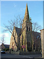
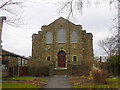
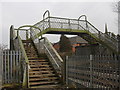
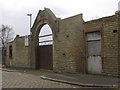
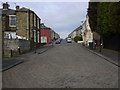
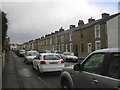
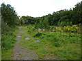
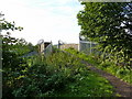
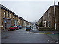
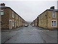
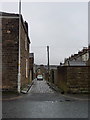
Photos of BB5 6DL

Area Information
BB5 6DL is a small residential postcode area in the Hyndburn Borough Council, nestled within Lancashire’s historic Blackburn region. With a population of 1,488, it forms part of the Peel Ward, a district shaped by early manorial divisions and textile industry roots. The area’s character is steeped in history, including ties to Sir Robert Peel, founder of the UK police force, whose birthplace near Cardwell Place is marked by a blue plaque. The Peel Hotel, built in the 1870s, stands as a local landmark. Despite its modest size, BB5 6DL offers a blend of historical terraced housing and modern amenities. Its proximity to Oswaldtwistle and Blackburn provides access to broader urban services while retaining a distinct local identity. Residents benefit from nearby rail links and a mix of retail options, though the area’s small footprint means its immediate surroundings hold the key to its full range of opportunities. For those seeking a quiet, historically rich community with practical connectivity, BB5 6DL presents a niche yet functional living environment.
- Area Type
- Postcode
- Area Size
- Not available
- Population
- 1488
- Population Density
- 9248 people/km²
The property market in BB5 6DL is characterised by a 43% home ownership rate, which is below the national average, suggesting a significant proportion of the area’s housing stock is rented out. The accommodation type is predominantly houses, which is notable for a small postcode area, as it implies a focus on individual or family homes rather than flats or apartments. This could indicate a mix of semi-detached and detached properties, though the exact distribution is unclear. The limited size of the area means the housing stock is not extensive, and buyers may need to look beyond BB5 6DL for more options. The relatively low home ownership rate may reflect affordability challenges or a preference for rental living among residents. For those considering purchase, the small footprint of the area means competition for properties could be keen, and proximity to nearby towns like Blackburn or Accrington may be necessary to access a broader range of housing choices.
House Prices in BB5 6DL
No properties found in this postcode.
Energy Efficiency in BB5 6DL
The lifestyle in BB5 6DL is supported by a range of nearby amenities within practical reach. Retail options include Spar, Iceland Accrington, and Aldi Milnshaw, providing access to everyday shopping needs. The area’s rail stations, such as Accrington and Huncoat, connect residents to broader networks, while the metro link to Rawtenstall offers additional mobility. Though the data does not list parks or leisure facilities explicitly, the proximity to Blackburn and Accrington suggests access to larger green spaces and recreational opportunities. The presence of multiple retail outlets and transport links contributes to a convenient, functional lifestyle, balancing local convenience with regional accessibility. For residents, this means a mix of self-contained living with the ability to engage with nearby urban amenities. The character of the area is defined by its small-scale retail and transport options, which support daily life without requiring extensive travel.
Amenities
Schools
The nearest school to BB5 6DL is the Accrington St John with St Augustine Church of England Primary School, which has an Ofsted rating of “good.” This primary school serves the local community, offering education for younger children. However, the data does not list any secondary schools in the immediate vicinity, which may require families to seek options in nearby towns such as Accrington or Blackburn. The presence of a well-rated primary school is a positive factor for families with young children, though the absence of secondary education facilities within the area could be a consideration for those planning long-term stays. The school’s “good” rating suggests it meets acceptable standards, but further research into its curriculum and facilities would be necessary for a comprehensive evaluation.
| Rank | School | Type | Entry gender | Ages |
|---|
Explore more schools in this area
Go to Schools tabDemographics
The population of BB5 6DL is predominantly middle-aged, with a median age of 47 and the most common age range being adults aged 30–64. This suggests a community of established residents, many of whom may be homeowners or long-term renters. Home ownership in the area stands at 43%, indicating a majority of households are renters. The accommodation type is primarily houses, which is unusual for a small postcode area, suggesting a mix of family homes and possibly larger properties. The predominant ethnic group is White, though no specific data on diversity or deprivation is provided. The age profile implies a stable, mature population, potentially with a focus on family living. However, the relatively low home ownership rate may reflect economic pressures or a preference for rental flexibility. The absence of detailed diversity statistics means the community’s full demographic composition remains partially unexplored.
Household Size
Accommodation Type
Tenure
Ethnic Group
Religion
Household Composition
Age
Household Deprivation
NS-SEC
Explore more demographic insights in this area
Go to Demographics tabPlanning
Planning Constraints
- Flood RiskPremium
- Ramsar Wetland SitesPremium
- Area of Outstanding Natural BeautyPremium
- Protected Nature ReservePremium
- Protected WoodlandPremium