Area Overview for BB5 1BN
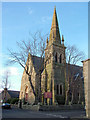
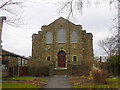
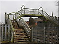
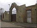
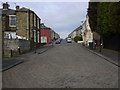
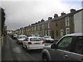
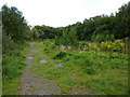
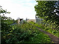
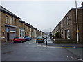
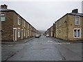
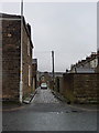
Photos of BB5 1BN

Area Information
Living in BB5 1BN means being part of a small, tightly knit residential cluster in Lancashire, England. With a population of 1,488, this area is defined by its historical roots in the textile industry and manorial land divisions. The community sits within the Peel Ward, a part of Hyndburn Borough Council, and is closely linked to the broader Blackburn region. The area’s character is shaped by its past, including ties to the Peel family, who once owned land in Oswaldtwistle. Today, the neighbourhood offers a mix of practical living with access to nearby rail networks and local amenities. The population is predominantly middle-aged, with a median age of 47, suggesting a stable, long-term resident base. While the area is small, its proximity to Accrington and Rawtenstall provides broader connectivity for work, leisure, and services. For those seeking a quiet, residential setting with historical depth, BB5 1BN balances simplicity with accessibility.
- Area Type
- Postcode
- Area Size
- Not available
- Population
- 1488
- Population Density
- 9248 people/km²
The property market in BB5 1BN is characterised by a 43% home ownership rate, with houses being the predominant accommodation type. This suggests a relatively small number of owner-occupied properties, which may indicate a rental market with more available homes for rent than purchase. The area’s small size means the housing stock is limited, but the presence of houses rather than flats or apartments implies a more traditional, suburban layout. For buyers, this could mean fewer opportunities for purchase, with competition likely focused on existing owner-occupied homes. The low population density and historical context of the area may also influence property values, with character homes potentially available. However, the limited data on property types or prices means the market’s specifics remain unclear. Buyers should consider the area’s small size and the potential for limited inventory when exploring options.
House Prices in BB5 1BN
No properties found in this postcode.
Energy Efficiency in BB5 1BN
The lifestyle in BB5 1BN is shaped by its proximity to practical amenities and transport links. Within walking or short driving distance are five retail venues, including Aldi Milnshaw, Spar, and Farmfoods Milnshaw, offering everyday shopping needs. The area’s rail stations—Accrington, Church & Oswaldtwistle, and Huncoat—provide access to nearby towns, while the Rawtenstall Metro station offers quicker travel to regional centres. These connections make the area convenient for commuters and those seeking broader services. The absence of larger leisure or cultural venues means residents may need to travel for entertainment, but the retail options and transport links provide a functional daily life. The character of the area is modest, with a focus on practicality and accessibility, reflecting its small-scale residential nature. For those prioritising convenience over sprawling amenities, BB5 1BN offers a straightforward, connected lifestyle.
Amenities
Schools
The nearest school to BB5 1BN is the Accrington St John with St Augustine Church of England Primary School, which serves the local community with a primary education offering. The school holds an Ofsted rating of “good,” indicating a satisfactory standard of teaching and facilities. As the only school listed in the data, it is the sole educational institution within practical reach of residents. Families with young children may find this school a reliable option, though the absence of secondary schools nearby means older students would need to commute to larger towns like Accrington or Blackburn. The mix of school types is limited to primary education, which could be a consideration for those requiring a full range of educational stages. The “good” rating suggests the school meets expected standards, but further details on its performance or facilities are not provided.
| Rank | School | Type | Entry gender | Ages |
|---|
Explore more schools in this area
Go to Schools tabDemographics
The community in BB5 1BN is predominantly composed of adults aged 30–64, with a median age of 47. This suggests a population skewed toward middle-aged residents, likely including families and professionals. Home ownership stands at 43%, which is below the national average, indicating a significant proportion of renters in the area. The accommodation type is primarily houses, reflecting a more spread-out residential layout compared to high-density housing. The predominant ethnic group is White, with no data provided on other demographics. This age profile and home ownership rate suggest a community with a mix of long-term residents and those in rental properties, possibly including younger professionals or families. The lower home ownership rate may influence local property dynamics, with fewer owner-occupied homes available for purchase. The absence of detailed diversity data means the area’s cultural composition remains less defined in the provided information.
Household Size
Accommodation Type
Tenure
Ethnic Group
Religion
Household Composition
Age
Household Deprivation
NS-SEC
Explore more demographic insights in this area
Go to Demographics tabPlanning
Planning Constraints
- Flood RiskPremium
- Ramsar Wetland SitesPremium
- Area of Outstanding Natural BeautyPremium
- Protected Nature ReservePremium
- Protected WoodlandPremium