Area Overview for BB4 7NA
Photos of BB4 7NA
Area Information
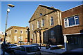
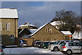
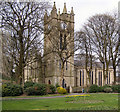
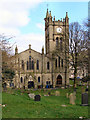
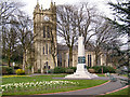
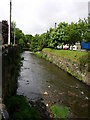
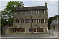
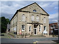
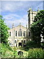
Living in BB4 7NA means residing in Waterfoot, a historic mill town situated in the Borough of Rossendale, Lancashire. This specific postcode cluster encompasses 524 square metres and serves a population of 1,648 residents. The area sits at the confluence of Whitewell Brook and the River Irwell, where the B6238 road from Burnley meets the A681. Historically, the town expanded during the 19th century due to its role in felt-making, cotton production, and silk weaving. You are standing in a location that has hosted the Karrimor business origins and features a distinctive canopied walkway known as Victoria or Trickett's Arcade. This structure, built between 1897 and March 1899 by Sir Henry Whittaker Trickett, forms a Town Centre Conservation Area with decorative iron and glass detailing. Residents live in close proximity to Bacup and Rawtenstall Grammar School, one of the few remaining state-funded selective entry schools in England. Daily life here involves navigating a community with deep industrial roots while accessing modern amenities within practical reach. The ward is coded BB4 and offers a setting familiar to those who appreciate Lancashire's working-class heritage. You find yourself in an area where past textile dominance meets present-day residential stability, anchored by significant community institutions like the grammar school and local transport hubs.
- Area Type
- Postcode
- Area Size
- 524 m²
- Population
- 1648
- Population Density
- 1023 people/km²
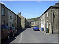
The property market in BB4 7NA is defined by a high level of owner occupancy. Seventy-five per cent of properties are owned by their residents, creating an owner-occupier dominated landscape. Houses form the predominant accommodation type within this postcode, meaning you will rarely encounter high-density rental blocks. This structure is typical of the waterfoot civil parish and the wider Rossendale borough surrounding areas. The small size of this specific 524 square metre cluster suggests a close-knit neighbourhood where property values are influenced by local school catchments and conservation area status. BCAUp and Rawtenstall Grammar School proximity likely adds value to local homes. While specific price-to-earnings ratios are absent from current records, the 75 per cent ownership figure indicates strong local equity. You are looking at a market where sellers are often long-term inhabitants seeking to retire or downsize, rather than speculative investors. The presence of a Town Centre Conservation Area restricts certain alterations, which can affect renovation potential. Buying in BB4 7NA means engaging with a stable housing stock where families have built roots over decades. The lack of frequent turnover in property ownership points to a reliable, albeit potentially slower-moving, market character.
House Prices in BB4 7NA
No properties found in this postcode.
Energy Efficiency in BB4 7NA
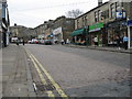
Daily life in BB4 7NA benefits from a concentration of retail and transport amenities within practical reach. Five major retail outlets operate nearby, including Lidl Rawtenstall, Asda Rawtenstall, and Tesco Rawtenstall. These supermarkets provide convenient access to groceries and household essentials without requiring long journeys. Two metro services in Rawtenstall and Ramsbottom complement the five main railway stations, including Accrington and Huncoat, ensuring flexible transport choices. The town centre itself features recreational and cultural points of interest. Victoria or Trickett's Arcade, a canopied walkway with decorative iron and glass, offers shade and architectural interest for pedestrians during warmer months. Local history is visible everywhere, from the origins of the Karrimor brand to the industrial remains of the textile past. Waterfoot Primary and St Anne's C of E Primary schools serve younger children, while Bacup and Rawtenstall Grammar School caters to secondary education. The B6238 and A681 roads provide easy access to wider Lancashire destinations. You will find all essential shopping and transit needs可满足 within a short commute. The area retains its historic charm without sacrificing modern convenience.
Amenities
Schools
| Rank | School | Type | Entry gender | Ages |
|---|
Explore more schools in this area
Go to Schools tabDemographics
The community profile for BB4 7NA reflects a mature, settled population. The median age stands at 47 years, with the most common age range comprising adults between 30 and 64 years. This demographic structure indicates an area dominated by established households rather than students or retirees. Home ownership is high at 75 per cent, signalling that the majority of residents reside in properties they own outright or with a mortgage. Housed in this postcode are primarily houses, which aligns with the broader character of the waterfoot parish. The predominant ethnic group within this cluster is White, mirroring historical settlement patterns in the Borough of Rossendale. You will find a neighbourhood where long-term residency is the norm, supported by stability indicators. The accommodation type data confirms that large blocks of private rental flats are not the defining feature here. Instead, families and dual-income households likely constitute the bulk of the social fabric. This steady demographic mix suggests a quiet environment where local schools and community facilities support an active, middle-aged populace. The high ownership rate implies that local businesses cater to a stable customer base rather than transient populations.
Household Size
Accommodation Type
Tenure
Ethnic Group
Religion
Household Composition
Age
Household Deprivation
NS-SEC
Explore more demographic insights in this area
Go to Demographics tabPlanning
Planning Constraints
- Flood RiskPremium
- Ramsar Wetland SitesPremium
- Area of Outstanding Natural BeautyPremium
- Protected Nature ReservePremium
- Protected WoodlandPremium