Area Overview for BB4 7HF
Photos of BB4 7HF
Area Information
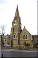
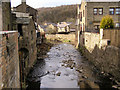
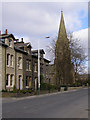
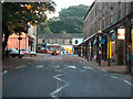
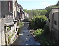
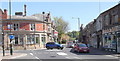
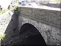
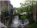
Living in BB4 7HF means being part of a small, tightly knit residential cluster in Waterfoot, a historic mill town in Lancashire’s Rossendale borough. With a population of 1,411, the area balances its industrial heritage with modern living. Waterfoot’s character is defined by its 19th-century canopied walkway, Victoria or Trickett’s Arcade, a conservation area that preserves its architectural charm. The town lies between Rawtenstall and Bacup, with the River Irwell and Whitewell Brook shaping its geography. Daily life here is grounded in local traditions and proximity to nearby towns, offering a mix of historic sites like Bacup and Rawtenstall Grammar School and practical amenities such as Co-op Waterfoot and Lidl Rawtenstall. The area’s compact size ensures a sense of community, though its small footprint means residents often travel to larger centres for broader services. The population, predominantly adults aged 30–64, reflects a mature demographic with a focus on stability, shaped by the town’s industrial past and ongoing local businesses.
- Area Type
- Postcode
- Area Size
- Not available
- Population
- 1411
- Population Density
- 2719 people/km²
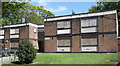
The property market in BB4 7HF is characterised by a 51% home ownership rate, indicating that nearly half of residents rent rather than own their homes. The area’s accommodation is predominantly houses, which contrasts with regions where flats or apartments dominate. This suggests a housing stock tailored to families or individuals preferring single-unit properties, rather than high-density living. Given the area’s small size, the property market is likely limited in scale, with buyers needing to consider nearby towns like Rawtenstall or Bacup for broader options. The 51% ownership rate also implies a rental market that could be competitive, particularly for those seeking long-term tenancies. For buyers, the focus on houses may appeal to those prioritising space and privacy, though the limited local supply could necessitate looking beyond BB4 7HF for larger selections.
House Prices in BB4 7HF
No properties found in this postcode.
Energy Efficiency in BB4 7HF
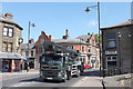
Residents of BB4 7HF have access to a range of local amenities, including five retail outlets such as Co-op Waterfoot, Lidl Rawtenstall, and Tesco Rawtenstall, ensuring everyday shopping needs are met. The area is served by two metro stops—Rawtenstall and Ramsbottom—and a rail connection to Accrington, facilitating travel to nearby towns. The historic character of Waterfoot, with its conservation area and canopied walkway, adds to the local appeal, blending heritage with practical living. The nearby Bacup and Rawtenstall Grammar School and Waterfoot Primary School contribute to a family-friendly environment, though secondary education requires commuting. The combination of retail options, transport links, and historic features creates a lifestyle that balances convenience with a sense of place, ideal for those valuing both modern amenities and a connection to the past.
Amenities
Schools
The nearest school to BB4 7HF is Rawtenstall Newchurch Church of England Primary School, a primary institution with a good Ofsted rating. This school serves the local community, offering education for younger children within walking distance of the area. While no secondary schools are listed in the immediate vicinity, families may need to consider commuting to nearby towns for secondary education. The presence of a well-rated primary school is a key advantage for families with young children, though the absence of a secondary school nearby could influence long-term housing decisions. The school’s good rating suggests a focus on quality teaching and facilities, which is critical for parents prioritising education. The mix of schools in the area, limited to primary level, means residents must plan for additional travel for older children.
| Rank | School | Type | Entry gender | Ages |
|---|
Explore more schools in this area
Go to Schools tabDemographics
The population of BB4 7HF is 1,411, with a median age of 47, indicating a mature demographic skewed towards adults aged 30–64. Home ownership sits at 51%, suggesting a mix of owner-occupied properties and rental units. The area is predominantly composed of houses, reflecting a traditional housing stock rather than apartments or flats. The predominant ethnic group is White, aligning with broader regional patterns. This age profile implies a community focused on long-term stability, with fewer young families compared to other areas. The 51% home ownership rate means nearly half of residents rent, which could influence local property dynamics. The absence of specific deprivation data means quality of life assessments rely on other factors, such as access to schools and transport. The demographic profile suggests a balance between established residents and those seeking housing in a historically industrious area.
Household Size
Accommodation Type
Tenure
Ethnic Group
Religion
Household Composition
Age
Household Deprivation
NS-SEC
Explore more demographic insights in this area
Go to Demographics tabPlanning
Planning Constraints
- Flood RiskPremium
- Ramsar Wetland SitesPremium
- Area of Outstanding Natural BeautyPremium
- Protected Nature ReservePremium
- Protected WoodlandPremium