Area Overview for BB4 4EP
Photos of BB4 4EP
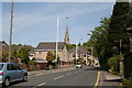
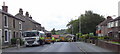
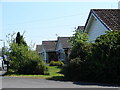
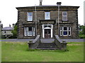

86 photos from this area
Area Information
Key information about the BB4 4EP including its size, population, and administrative classification.
- Area Type
- Postcode
- Area Size
- 4690 m²
- Population
- 1462
- Population Density
- 5941 people/km²
House Prices in BB4 4EP
18
Properties
£94,640
Average Sold Price
£20,000
Lowest Price
£172,500
Highest Price
Showing 18 properties
| Address | Type | Beds | Baths | Last Sale Price | Last Sale Date | |
|---|---|---|---|---|---|---|
| 8 Somerset Walk, Haslingden, Rossendale, BB4 4EP | Terraced | 3 | 1 | £158,677 | Dec 2024 | |
| 11 Somerset Walk, Haslingden, Rossendale, BB4 4EP | Semi-detached | 3 | 1 | £172,500 | May 2023 | |
| 5 Somerset Walk, Haslingden, Rossendale, BB4 4EP | house | - | - | £135,000 | Jul 2021 | |
| 3 Somerset Walk, Haslingden, Rossendale, BB4 4EP | Terraced | 3 | 1 | £99,950 | Dec 2017 | |
| 16 Somerset Walk, Haslingden, Rossendale, BB4 4EP | Terraced | - | - | £55,000 | Dec 2003 | |
| 14 Somerset Walk, Haslingden, Rossendale, BB4 4EP | Terraced | - | - | £21,350 | Jul 2003 | |
| 7 Somerset Walk, Haslingden, Rossendale, BB4 4EP | Terraced | - | - | £20,000 | Aug 1999 | |
| 9 Somerset Walk, Haslingden, Rossendale, BB4 4EP | Terraced | 3 | 1 | - | - | |
| 10 Somerset Walk, Haslingden, Rossendale, BB4 4EP | Terraced | 3 | 1 | - | - | |
| 12 Somerset Walk, Haslingden, Rossendale, BB4 4EP | Terraced | 3 | 1 | - | - |
Page 1 of 2
Energy Efficiency in BB4 4EP
Amenities
Schools
| Rank | School | Type | Entry gender | Ages |
|---|
Explore more schools in this area
Go to Schools tabDemographics
Household Size
One person
most common
Accommodation Type
Houses
most common
Tenure
54
majority
Ethnic Group
White
most common
Religion
N/A
most common
Household Composition
N/A
most common
Age
47
median
Adults (30-64 years)
most common
Household Deprivation
N/A
with no deprivation
NS-SEC
23
in Lower managerial occupations
Explore more demographic insights in this area
Go to Demographics tabPlanning
Planning Constraints
- Flood RiskPremium
- Ramsar Wetland SitesPremium
- Area of Outstanding Natural BeautyPremium
- Protected Nature ReservePremium
- Protected WoodlandPremium