Area Overview for BB2 6SQ
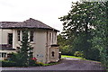
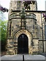
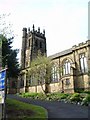
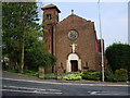
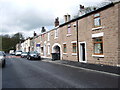
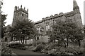
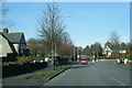
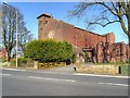
Photos of BB2 6SQ
Area Information
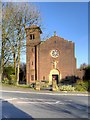
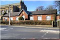
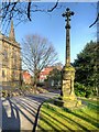
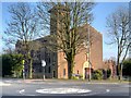
BB2 6SQ is a small residential postcode in England, part of the West End of Blackburn. With a population of 1,609 and a density of 540 people per square kilometre, it reflects a compact, tightly knit community. The area’s history is rooted in Victorian housing developments and early 19th-century infrastructure, such as Billinge Avenue and Preston New Road. Neighbouring landmarks include the historic Billinge Scar, once home to mill-owning families, and St Silas Church, built in 1898. Daily life here is shaped by its proximity to schools, retail, and rail links, while the demographic profile—skewed toward adults aged 30–64—suggests a stable, family-oriented environment. The area’s low crime risk and absence of environmental constraints make it a practical choice for those prioritising safety and accessibility. Its small size means residents are likely to know their neighbours, and the mix of local amenities ensures convenience without the bustle of larger urban centres.
- Area Type
- Postcode
- Area Size
- Not available
- Population
- 1609
- Population Density
- 540 people/km²
BB2 6SQ is primarily an owner-occupied area, with 82% of homes owned by residents rather than rented. The accommodation type is predominantly houses, which is typical of the area’s historical development. This suggests a market skewed toward family homes, with limited rental stock, making it a less common choice for investors seeking short-term returns. The small size of the postcode means the housing stock is finite, and buyers may need to consider nearby areas for more options. The high home ownership rate also implies stable property values and a community focused on long-term residency. For those seeking a home, the availability of houses in a low-risk, low-crime area could be a strong selling point, though the compact nature of the postcode may limit choice. Proximity to rail links and schools further enhances its appeal for families.
House Prices in BB2 6SQ
No properties found in this postcode.
Energy Efficiency in BB2 6SQ
The lifestyle in BB2 6SQ is shaped by its access to retail and transport hubs. Nearby shops include Morrisons Daily West End, Tesco Blackburn, and Aldi Wensley, offering a range of grocery and convenience options. These stores provide daily essentials, reducing the need for long trips. The rail stations—Mill Hill, Cherry Tree, and Blackburn—connect residents to broader networks, enabling easy travel for work, leisure, or shopping. The area’s compact size means amenities are within practical reach, fostering a convenient, self-contained environment. While parks and green spaces are not explicitly mentioned, the absence of planning constraints like AONBs or protected woodlands suggests open spaces may be limited. Nonetheless, the blend of retail, transport, and historical character contributes to a balanced lifestyle, combining practicality with a sense of community.
Amenities
Schools
The schools near BB2 6SQ include Beardwood Humanities College, Witton Park High School, and Tauheedul Islam Girls High School, all of which are primary institutions. The Olive School in Blackburn is an academy with an outstanding Ofsted rating, while Witton Park Academy is another academy rated as good. This mix of primary schools and academies offers families a range of educational options, from traditional state schools to high-performing academies. The presence of an outstanding-rated school, The Olive School, suggests strong academic provision in the area, which is a key consideration for parents. The variety of school types may cater to different educational philosophies, from faith-based institutions to academies with broader curricula. For families prioritising school quality, the proximity to these institutions is a significant advantage, though the small postcode size means catchment areas may be limited.
| Rank | School | Type | Entry gender | Ages |
|---|
Explore more schools in this area
Go to Schools tabDemographics
The population of BB2 6SQ is 1,609, with a median age of 47 and the majority of residents aged 30–64. This suggests a mature, established community with a strong presence of middle-aged households. Home ownership is high at 82%, indicating a stable residential base with fewer rental properties. The predominant accommodation type is houses, which aligns with the area’s historical development of Victorian housing. The largest ethnic group is the Asian community, reflecting broader demographic trends in Blackburn. This composition influences local culture and services, with schools and amenities catering to a diverse but cohesive population. The absence of specific deprivation data means quality of life is inferred from low crime rates and good infrastructure. The age profile also implies a balance between active professionals and retirees, contributing to a steady, low-turnover housing market.
Household Size
Accommodation Type
Tenure
Ethnic Group
Religion
Household Composition
Age
Household Deprivation
NS-SEC
Explore more demographic insights in this area
Go to Demographics tabPlanning
Planning Constraints
- Flood RiskPremium
- Ramsar Wetland SitesPremium
- Area of Outstanding Natural BeautyPremium
- Protected Nature ReservePremium
- Protected WoodlandPremium