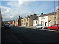
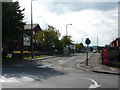
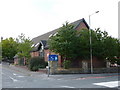
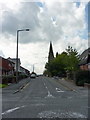
Area Overview for BB2 3RD
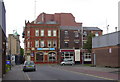
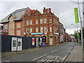
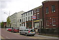
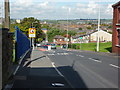
Photos of BB2 3RD
Area Information
BB2 3RD is a small residential postcode area nestled in Blackburn, Lancashire. With a population of 1300, it is a compact community centred around Blackburn’s core, near the coordinates 53.749199, -2.482185. This area forms part of Blackburn Central electoral ward, which includes streets like Alexandra Road, Corporation Park, and Lilford Road. Daily life here is shaped by its proximity to the town’s industrial heritage and modern infrastructure. Residents benefit from nearby motorways like the M65, which links to Preston and Colne, and the A677, which runs through the town centre. The area’s compact size means amenities and services are within practical reach, making it convenient for those who prioritise accessibility. While Blackburn itself is a hub of activity, BB2 3RD retains a quieter, residential character, blending historic charm with contemporary needs. Its location, 8 miles east of Preston and 21 miles north of Manchester, positions it as a strategic spot for commuters and families seeking a balance between urban and suburban living.
- Area Type
- Postcode
- Area Size
- Not available
- Population
- 1300
- Population Density
- 2564 people/km²
The property market in BB2 3RD is characterised by a 46% home ownership rate, with houses being the primary accommodation type. This indicates a market skewed towards rental properties, as fewer than half of residents own their homes. The prevalence of houses suggests a focus on family-oriented housing, though the small size of the area limits the variety of available properties. Buyers should expect a mix of owner-occupied and rental homes, with potential competition for available properties. The compact nature of the postcode means the immediate surroundings—such as nearby streets like Bingham and Ar Bank Road—may offer additional options. However, the lower home ownership rate could signal a reliance on private rentals, which may affect long-term investment potential. For those seeking a home, the area’s proximity to Blackburn’s amenities and transport links adds value, though the limited housing stock may require flexibility in location or property type.
House Prices in BB2 3RD
No properties found in this postcode.
Energy Efficiency in BB2 3RD
Living in BB2 3RD offers access to a range of amenities within practical reach. Retail options include Asda Blackburn, Lidl Central, and Farmfoods Blackburn, providing essential shopping and grocery needs. The area’s rail stations—Blackburn, Mill Hill, and Cherry Tree—connect residents to broader networks, while the M65 motorway ensures easy travel to nearby towns. Nearby green spaces such as Corporation Park and Playing Field offer recreational opportunities, contributing to a balanced lifestyle. The compact nature of the area means that daily errands, leisure, and transport are all within a short distance. For families, the availability of retail and green spaces supports both practical and social needs. The presence of local shops and transport links enhances convenience, making BB2 3RD a practical choice for those prioritising accessibility and a mix of urban and suburban amenities.
Amenities
Schools
| Rank | School | Type | Entry gender | Ages |
|---|
Explore more schools in this area
Go to Schools tabDemographics
The median age in BB2 3RD is 47, with the most common age range being adults aged 30–64. This suggests a community of middle-aged individuals, likely including professionals and families. Home ownership stands at 46%, indicating that nearly half of residents rent their homes, while the remaining 54% are likely in rental properties or other tenures. The predominant accommodation type is houses, reflecting a focus on family homes rather than apartments. The predominant ethnic group is White, which aligns with broader demographic trends in Blackburn. This data implies a stable, established community with a moderate level of deprivation, as the lower home ownership rate may indicate a reliance on rental markets or shared housing. The age profile suggests a mix of long-term residents and those in their prime working years, shaping the area’s social dynamics and local services.
Household Size
Accommodation Type
Tenure
Ethnic Group
Religion
Household Composition
Age
Household Deprivation
NS-SEC
Explore more demographic insights in this area
Go to Demographics tabPlanning
Planning Constraints
- Flood RiskPremium
- Ramsar Wetland SitesPremium
- Area of Outstanding Natural BeautyPremium
- Protected Nature ReservePremium
- Protected WoodlandPremium