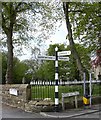
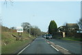
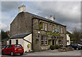
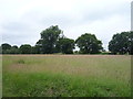
Area Overview for BB12 9BY
Photos of BB12 9BY
Area Information
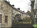
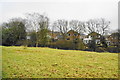
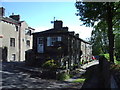
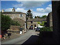
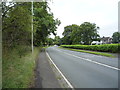
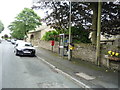
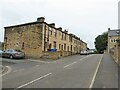
BB12 9BY is a small, compact residential area in Lancashire, England, with a population of 1,714 spread across 3 hectares. Situated in the Pendle district, it is part of the civil parish of Higham with West Close Booth, a historically agricultural region with roots in 13th-century farmsteads. The area retains a quiet, village-like character, with homes predominantly built as houses rather than flats. Its proximity to Padiham and Whalley offers access to broader services, while its low population density ensures a sense of space. The community is largely composed of adults aged 30–64, reflecting a mature demographic. Nearby, the Higham Conservation Area preserves historic features like Higham Hall, a Grade II listed building, and 19th-century mill-related terraces. Residents benefit from proximity to primary schools, rail links, and local retail, making it a practical choice for families seeking a blend of tradition and convenience.
- Area Type
- Postcode
- Area Size
- 3.0 hectares
- Population
- 1714
- Population Density
- 60 people/km²
The property market in BB12 9BY is characterised by high home ownership (83%) and a predominance of houses over flats, reflecting its rural and semi-rural nature. This suggests a community of long-term residents rather than a transient rental market. The small area size (3 hectares) means housing stock is limited, with properties likely to be older, given the historical development of the parish in the 13th century and 19th-century mill-related terraces. Buyers should consider the proximity to amenities like schools, rail links, and retail, which are within practical reach. The area’s low population density and stable demographics may make it attractive to families seeking a quieter, established neighbourhood. However, the limited housing stock could mean fewer options for buyers, necessitating a focus on nearby areas for additional choices.
House Prices in BB12 9BY
Showing 33 properties
| Address | Type | Beds | Baths | Last Sale Price | Last Sale Date | |
|---|---|---|---|---|---|---|
| 27 Acresbrook Road, Higham, BB12 9BY | Detached | 4 | 1 | £375,000 | Mar 2025 | |
| 8 Acresbrook Road, Higham, BB12 9BY | house | - | - | £440,000 | Feb 2025 | |
| 28 Acresbrook Road, Higham, BB12 9BY | Detached | 4 | 1 | £425,000 | Jul 2024 | |
| 19 Acresbrook Road, Higham, BB12 9BY | house | 3 | 3 | £500,000 | Apr 2023 | |
| 30 Acresbrook Road, Higham, BB12 9BY | Bungalow | - | - | £325,000 | Jan 2022 | |
| 6 Acresbrook Road, Higham, BB12 9BY | Detached | 3 | 1 | £411,500 | Jun 2021 | |
| 40 Acresbrook Road, Higham, BB12 9BY | Detached | 4 | - | £287,500 | Jul 2017 | |
| 23 Acresbrook Road, Higham, BB12 9BY | Bungalow | 3 | 2 | £255,000 | Oct 2016 | |
| 16 Acresbrook Road, Higham, BB12 9BY | Detached | 4 | 2 | £272,000 | Oct 2016 | |
| 25 Acresbrook Road, Higham, BB12 9BY | house | - | - | £272,500 | Apr 2014 |
Energy Efficiency in BB12 9BY
The lifestyle in BB12 9BY is shaped by its proximity to retail, dining, and transport hubs. Within walking distance are shops such as Lidl Padiham, Tesco Padiham, and Spar, offering everyday essentials. The area’s rail network, with stations like Brierfield and Burnley Barracks, provides easy access to nearby towns, enhancing convenience for shopping, leisure, and work. The Higham Conservation Area adds historical character, with listed buildings and 19th-century mill-related terraces contributing to a distinct local identity. While the area lacks large parks or leisure facilities, its small size and rural setting likely offer green spaces for walking or recreation. The presence of multiple primary schools and a mix of retail options suggests a community-oriented environment where daily life is balanced between tradition and practicality.
Amenities
Schools
Residents of BB12 9BY have access to four primary schools within the area. These include Roughlee Church of England Primary School, Higham St John’s Church of England Primary School, and Newchurch-in-Pendle St Mary’s Church of England Primary School, which has an Ofsted rating of ‘good’. The duplication of school names (e.g., Newchurch-in-Pendle St Mary’s listed twice) suggests a potential for multiple school options, though the exact locations and catchment areas are not specified. The presence of multiple primary schools with at least one rated ‘good’ indicates a strong foundation for early education. Families may benefit from having several schools to choose from, though the lack of secondary schools in the immediate area would require commuting. The schools’ Church of England affiliations align with the area’s historical and religious heritage.
| Rank | School | Type | Entry gender | Ages |
|---|
Explore more schools in this area
Go to Schools tabDemographics
The population of BB12 9BY has a median age of 47, with the majority of residents falling into the 30–64 age range. This suggests a community of established adults, many of whom may be in their prime working years or nearing retirement. Home ownership is high, at 83%, indicating a stable, long-term resident base rather than a transient rental market. The area is predominantly composed of houses, not flats, which aligns with its rural character and lower population density. The predominant ethnic group is White, reflecting the broader demographic trends in the Pendle district. With 60 people per square kilometre, the area is sparsely populated, offering a quieter lifestyle compared to urban centres. This density also means fewer shared spaces, which may appeal to those seeking privacy. The lack of specific deprivation data means the area’s quality of life is likely shaped by its low crime rates and access to amenities.
Household Size
Accommodation Type
Tenure
Ethnic Group
Religion
Household Composition
Age
Household Deprivation
NS-SEC
Explore more demographic insights in this area
Go to Demographics tabPlanning
Planning Constraints
- Flood RiskPremium
- Ramsar Wetland SitesPremium
- Area of Outstanding Natural BeautyPremium
- Protected Nature ReservePremium
- Protected WoodlandPremium