Area Overview for BB12 9AB
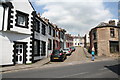
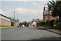
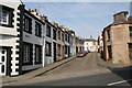
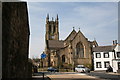
Photos of BB12 9AB
Area Information
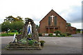
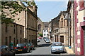
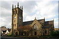
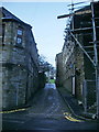
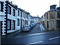
BB12 9AB lies within the historic market town of Padiham in Lancashire, a small but characterful area nestled near the River Calder and Pendle Hill. This postcode covers just 2.8 hectares, housing a population of 1,561 people in a densely packed residential cluster. The area’s compact size and high population density of 55,374 people per square kilometre reflect its long-standing role as a market town, with roots tracing back to the Anglo-Saxon era. Today, it balances its heritage with modern living, offering a mix of conservation areas and practical amenities. The town’s centre is preserved as a conservation area, while its proximity to Burnley and the surrounding countryside provides a blend of urban and rural influences. Daily life here is shaped by its history as a hub for textiles and coal, with remnants like the 16th-century buildings and Grade II-listed St Leonard’s Parish Church adding to its distinct character. For buyers, BB12 9AB represents a compact, tightly knit community with a focus on heritage and accessibility.
- Area Type
- Postcode
- Area Size
- 2.8 hectares
- Population
- 1561
- Population Density
- 2201 people/km²
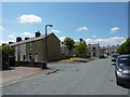
BB12 9AB is a small, tightly packed area where 50% of residents own their homes, with houses being the primary accommodation type. This suggests a mix of owner-occupied properties and rental units, though the limited area size of 2.8 hectares means housing stock is constrained. The predominance of houses over flats or apartments indicates a focus on traditional, single-family homes, many of which may date back to the 19th-century industrial era. The area’s conservation status means properties often retain historical features, though this can also limit modernisation. Buyers should consider the compact nature of the postcode, as nearby areas like Padiham offer more extensive housing options. For those seeking a home, the mix of heritage and practicality here could appeal to buyers valuing characterful living without sacrificing proximity to amenities.
House Prices in BB12 9AB
Showing 20 properties
| Address | Type | Beds | Baths | Last Sale Price | Last Sale Date | |
|---|---|---|---|---|---|---|
| 18 Pennine Grove, Padiham, BB12 9AB | Bungalow | 4 | 2 | £440,000 | Nov 2023 | |
| 14 Pennine Grove, Padiham, BB12 9AB | Detached | 5 | 2 | £590,000 | Aug 2021 | |
| 16A Pennine Grove, Padiham, BB12 9AB | house | - | - | £360,000 | Sep 2020 | |
| 11 Pennine Grove, Padiham, BB12 9AB | Bungalow | 3 | 1 | £275,000 | May 2019 | |
| 12 Pennine Grove, Padiham, BB12 9AB | Detached | 4 | 2 | £320,000 | Oct 2018 | |
| 2 Pennine Grove, Padiham, BB12 9AB | Bungalow | 4 | 4 | £375,000 | May 2016 | |
| 10 Pennine Grove, Padiham, BB12 9AB | house | - | - | £353,500 | Oct 2015 | |
| 5 Pennine Grove, Padiham, BB12 9AB | Detached | 4 | - | £300,000 | Nov 2014 | |
| 1 Pennine Grove, Padiham, BB12 9AB | Bungalow | 4 | - | £230,000 | Jun 2014 | |
| 22 Pennine Grove, Padiham, BB12 9AB | Bungalow | 3 | - | £247,500 | Jun 2014 |
Energy Efficiency in BB12 9AB
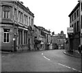
BB12 9AB offers a blend of practical retail and historical charm. Nearby shops include Lidl Padiham, Tesco Padiham, and Spar, providing essentials within walking distance. The area’s rail stations—Hapton, Rose Grove, and Burnley Barracks—connect residents to Burnley and further afield, while the nearby Leeds and Liverpool Canal adds a touch of leisure. Padiham’s conservation status means residents live near Grade II-listed sites like St Leonard’s Parish Church and the preserved Victoria Mill, now converted into flats. The 16th-century buildings and nearby Gawthorpe Hall, a National Trust site, add to the area’s character. Daily life here combines convenience with heritage, offering a compact yet well-served environment for those who value accessibility and historical depth.
Amenities
Schools
| Rank | School | Type | Entry gender | Ages |
|---|
Explore more schools in this area
Go to Schools tabDemographics
The population of BB12 9AB is 1,561, with a median age of 47, indicating a community skewed towards adults aged 30–64. This age range dominates, suggesting a stable, mature population with established careers and family ties. Home ownership sits at 50%, with houses being the primary accommodation type, reflecting a preference for single-family living. The predominant ethnic group is White, though no further diversity data is available. The area’s high population density—55,374 people per square kilometre—means living spaces are closely packed, which can influence community dynamics and local infrastructure. While this density may create a sense of neighbourliness, it also underscores the need for efficient planning. The demographic profile suggests a community with a strong emphasis on stability, though the lack of detailed diversity metrics means broader social composition remains unclear.
Household Size
Accommodation Type
Tenure
Ethnic Group
Religion
Household Composition
Age
Household Deprivation
NS-SEC
Explore more demographic insights in this area
Go to Demographics tabPlanning
Planning Constraints
- Flood RiskPremium
- Ramsar Wetland SitesPremium
- Area of Outstanding Natural BeautyPremium
- Protected Nature ReservePremium
- Protected WoodlandPremium