Area Overview for BB12 8GJ
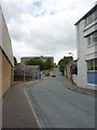
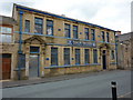
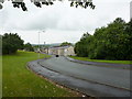
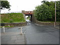
Photos of BB12 8GJ

Area Information
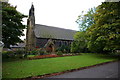
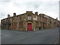
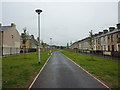
Living in BB12 8GJ means being part of a small, tightly knit residential cluster in the civil parish of Padiham, Lancashire. This postcode area, with a population of 1,266 and a density of 722 people per square kilometre, reflects the character of a historic market town rooted in Anglo-Saxon origins. Padiham’s centre is a conservation area, preserving its heritage as a trading hub for Pendleside’s produce. The area’s compact size means residents are close to its notable features: St Leonard’s Parish Church, a Grade II-listed building from 1866, and Victoria Mill, a 19th-century cotton mill now converted into flats. Daily life here blends quiet residential living with the legacy of industrial history, from the former coal mines to the 19th-century railway that once connected the town. With its proximity to Burnley and Pendle Hill, BB12 8GJ offers a mix of rural charm and small-town accessibility, ideal for those seeking a slower pace without being isolated from essential services.
- Area Type
- Postcode
- Area Size
- Not available
- Population
- 1266
- Population Density
- 722 people/km²
The property market in BB12 8GJ is defined by a high rate of home ownership (64%) and a focus on houses as the primary accommodation type. This suggests a market skewed towards owner-occupied properties rather than rental demand, which is typical of smaller, established communities. The limited size of the postcode area means housing stock is constrained, with few new developments likely to arise. For buyers, this implies a limited selection of homes, predominantly traditional properties rather than modern apartments. The concentration of houses may appeal to those seeking family-friendly, low-density living, though the small area size could mean competition for available properties. Proximity to nearby towns like Burnley might offer additional options for those willing to commute. Overall, BB12 8GJ is not a hotspot for speculative investment but suits buyers prioritising stability and historical character over rapid growth.
House Prices in BB12 8GJ
No properties found in this postcode.
Energy Efficiency in BB12 8GJ
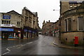
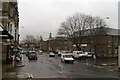
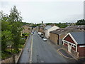
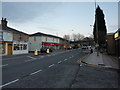
Living in BB12 8GJ provides access to a modest but practical range of amenities within walking or short driving distance. Retail options include Lidl Padiham, Tesco Padiham, and Spar, offering everyday shopping needs. The nearby railway stations—Hapton, Rose Grove, and Huncoat—connect residents to broader transport networks, facilitating travel to nearby towns and cities. While the area lacks large commercial centres, its small-scale retail and transport links contribute to a self-contained lifestyle. The historical character of Padiham, including its conservation area and listed buildings, adds a distinct cultural dimension. For leisure, the proximity to Pendle Hill and the River Calder offers opportunities for walking or outdoor activities. The blend of local shops, rail access, and natural surroundings creates a balanced lifestyle, though residents may need to travel further for more specialised services or entertainment.
Amenities
Schools
The nearest school to BB12 8GJ is Padiham St Leonard’s Voluntary Aided Church of England Primary School, a primary institution with an Ofsted rating of satisfactory. This school serves the local community, providing education for younger children in a setting that blends historical and contemporary elements. The absence of secondary schools in the immediate area means families may need to consider commuting to nearby towns for secondary education. However, the presence of a primary school with a satisfactory rating indicates a baseline level of educational provision. For families prioritising proximity to schools, this primary institution offers a practical option, though the limited range of educational facilities may require planning for longer-term needs. The school’s status as a voluntary aided institution suggests it may have specific governance or funding arrangements, which could influence its resources and priorities.
| Rank | School | Type | Entry gender | Ages |
|---|
Explore more schools in this area
Go to Schools tabDemographics
The community in BB12 8GJ is predominantly middle-aged, with a median age of 47 and the most common age range being 30–64 years. This suggests a stable, established population with strong ties to the area. Home ownership is high at 64%, indicating a preference for long-term residency over rental properties. The accommodation type is primarily houses, reflecting a more traditional housing stock compared to flats or apartments. The predominant ethnic group is White, aligning with broader regional demographics. While no specific data on deprivation is provided, the high home ownership rate and age profile suggest a community focused on stability and family life. The absence of detailed diversity metrics means the area’s social composition remains largely homogenous, though this does not necessarily reflect a lack of inclusivity. Residents here likely value the quiet, residential character of the postcode and its historical connections.
Household Size
Accommodation Type
Tenure
Ethnic Group
Religion
Household Composition
Age
Household Deprivation
NS-SEC
Explore more demographic insights in this area
Go to Demographics tabPlanning
Planning Constraints
- Flood RiskPremium
- Ramsar Wetland SitesPremium
- Area of Outstanding Natural BeautyPremium
- Protected Nature ReservePremium
- Protected WoodlandPremium