Area Overview for BB12 8DZ
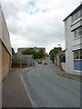
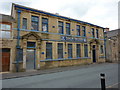
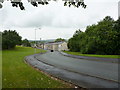
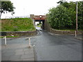
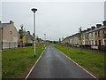
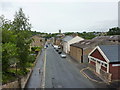
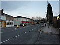
Photos of BB12 8DZ

Area Information
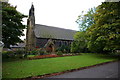
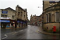
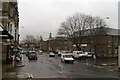
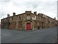
BB12 8DZ lies in Padiham, a small market town in Lancashire’s Burnley Borough, centred on the River Calder. This compact area, spanning 2,958 m², is home to 1,623 residents, making it one of the most densely populated places in England, with 548,599 people per km². Padiham’s history as a market town dates to Anglo-Saxon times, with its name deriving from “homestead of Padda.” The town’s conservation area preserves its 19th-century character, including St Leonard’s Parish Church and Padiham Town Hall. Today, it is a quiet residential cluster, with no major employers but proximity to Burnley and Pendle Hill. Daily life revolves around local amenities, historic sites, and rail links. The area’s compact size and high density mean it feels intimate, though its industrial past—once dominated by cotton mills and coal mining—has left a legacy of older housing stock. Padiham’s charm lies in its blend of heritage and practicality, with a focus on community and local connectivity.
- Area Type
- Postcode
- Area Size
- 2958 m²
- Population
- 1623
- Population Density
- 4332 people/km²
The property market in BB12 8DZ is characterised by a 43% home ownership rate, indicating that most properties are rented rather than owned. The accommodation type is primarily houses, which suggests a mix of older, possibly larger homes and smaller family dwellings. Given the area’s small size and high population density, the housing stock is limited, and competition for properties may be keen. The presence of historic buildings, such as the Grade II-listed Padiham Town Hall and the repurposed Victoria Mill flats, hints at a blend of traditional and modern housing. For buyers, this means a focus on existing properties rather than new developments. The area’s compact nature and proximity to rail links may appeal to those seeking a balance between residential tranquility and urban connectivity, though the high density could limit availability for those prioritising space.
House Prices in BB12 8DZ
Showing 3 properties
| Address | Type | Beds | Baths | Last Sale Price | Last Sale Date | |
|---|---|---|---|---|---|---|
| 5 Darwen Street, Padiham, BB12 8DZ | house | - | - | £40,950 | Jul 2013 | |
| 1 Darwen Street, Padiham, BB12 8DZ | house | - | - | - | - | |
| 3 Darwen Street, Padiham, BB12 8DZ | house | - | - | - | - |
Energy Efficiency in BB12 8DZ
Living in BB12 8DZ offers access to a range of practical amenities within walking or short driving distance. Retail options include Lidl Padiham, Tesco Padiham, and Spar, providing daily essentials. The area’s rail stations—Hapton, Rose Grove, and Burnley Barracks—connect residents to Burnley and other regional hubs, enhancing mobility. Historically, Padiham was a market town, and its conservation area status preserves landmarks like St Leonard’s Parish Church and Padiham Town Hall. Nearby, the National Trust’s Gawthorpe Hall and the River Calder offer leisure opportunities. The compact layout ensures convenience, though the high population density may mean limited green space. The blend of historic sites, local shops, and rail links creates a lifestyle that balances tradition with practicality, ideal for those seeking a connected yet low-key community.
Amenities
Schools
| Rank | School | Type | Entry gender | Ages |
|---|
Explore more schools in this area
Go to Schools tabDemographics
The population of BB12 8DZ has a median age of 47, with the majority of residents aged 30–64. This suggests a mature, established community, likely with families and long-term residents. Home ownership is low at 43%, indicating a rental market dominates, with 57% of households likely renting. The accommodation type is predominantly houses, reflecting a mix of older properties and single-family homes. The predominant ethnic group is White, with no data on other demographics. The high population density—over half a million people per km²—means the area is intensely populated for its size, which can impact living space and community dynamics. While the data does not specify deprivation levels, the low home ownership and older demographic suggest potential challenges in housing affordability and generational turnover.
Household Size
Accommodation Type
Tenure
Ethnic Group
Religion
Household Composition
Age
Household Deprivation
NS-SEC
Explore more demographic insights in this area
Go to Demographics tabPlanning
Planning Constraints
- Flood RiskPremium
- Ramsar Wetland SitesPremium
- Area of Outstanding Natural BeautyPremium
- Protected Nature ReservePremium
- Protected WoodlandPremium