Area Overview for BB12 7NP
Photos of BB12 7NP
Area Information
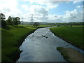
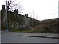
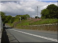
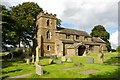
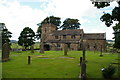
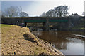
Living in BB12 7NP means being part of a small, tightly knit village in the Ribble Valley, Lancashire. With a population of 1,417 spread across 15.8 hectares, this area feels like a quiet retreat, where the pace of life is measured and the sense of community is strong. Situated in a historic civil parish with roots stretching back centuries, BB12 7NP is home to 22 listed buildings, including the ecclesiastical parish of Simonstone St Peter. The village’s character is defined by its residential cluster, with most homes built for long-term occupancy. Residents here benefit from proximity to nearby towns like Padiham, while the area retains a rural charm. Daily life is shaped by the village’s historical ties to landowning families like the Cockshutt and Starkie, though modern amenities such as local shops and railway stations ensure practicality. For those seeking a balance between tradition and convenience, BB12 7NP offers a distinct blend of heritage and accessibility.
- Area Type
- Postcode
- Area Size
- 15.8 hectares
- Population
- 1417
- Population Density
- 250 people/km²
The property market in BB12 7NP is characterised by high home ownership (78%) and a focus on houses rather than flats or apartments. This reflects the area’s small, residential nature, where larger homes are the norm. As a village with limited expansion, the housing stock is finite, making properties here potentially more valuable in the long term. For buyers, this means fewer rental options and a market skewed toward owner-occupiers. The predominance of houses suggests a demand for family-friendly living, with properties likely offering space and privacy. Given the area’s proximity to amenities like schools and rail links, properties here may appeal to those seeking a balance between rural tranquillity and practical connectivity. However, the small size of the area means buyers must consider nearby towns for additional housing choices.
House Prices in BB12 7NP
Showing 11 properties
| Address | Type | Beds | Baths | Last Sale Price | Last Sale Date | |
|---|---|---|---|---|---|---|
| Holmrook, Simonstone Lane, Simonstone, BB12 7NP | house | - | - | £675,000 | Jan 2021 | |
| Allandale, Simonstone Lane, Simonstone, BB12 7NP | Semi-detached | 4 | 2 | £420,000 | Aug 2020 | |
| Thorney Bank, Simonstone Lane, Simonstone, BB12 7NP | Semi-detached | 4 | 2 | £393,000 | Aug 2019 | |
| Rosegarth, Simonstone Lane, Simonstone, BB12 7NP | Semi-detached | 4 | 3 | £390,000 | Jul 2018 | |
| 22 Simonstone Lane, Simonstone, BB12 7NP | house | - | - | £143,000 | Nov 2013 | |
| Simonstone House, Simonstone Lane, Simonstone, BB12 7NP | Detached | - | - | £272,000 | May 2009 | |
| Koonah, Simonstone Lane, Simonstone, BB12 7NP | Semi-detached | - | - | £342,750 | Dec 2007 | |
| Revishaw, Simonstone Lane, Simonstone, BB12 7NP | Detached | - | - | £445,000 | Aug 2003 | |
| Tunstead Coach House, Simonstone Lane, Simonstone, BB12 7NP | Detached | 6 | 3 | £100,000 | Dec 2002 | |
| Tunstead House, Simonstone Lane, Simonstone, BB12 7NP | Detached | 6 | 3 | - | - |
Energy Efficiency in BB12 7NP
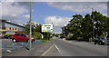
The lifestyle in BB12 7NP is shaped by its proximity to local amenities, including five retail outlets such as Spar, Lidl Padiham, and Tesco Padiham. These shops provide everyday essentials, reducing the need for long trips to larger centres. The village’s small size means amenities are within practical reach, fostering convenience without sacrificing charm. While the area lacks large leisure facilities, its rural setting offers access to open spaces and historical sites like Gawthorpe Hall. The presence of railway stations adds to the area’s accessibility, allowing residents to explore nearby towns or cultural hubs. This blend of local retail, transport links, and historical surroundings creates a lifestyle that balances simplicity with practicality, ideal for those valuing a close-knit community.
Amenities
Schools
Residents of BB12 7NP have access to two primary schools: Read St John’s CofE Primary School and Simonstone St Peter’s Church of England Primary School. Both are rated as ‘good’ by Ofsted, ensuring a solid foundation for early education. The presence of two primary schools within the area provides families with options, reducing the need for long commutes to larger towns. These schools likely cater to the local community’s needs, with a focus on small-class teaching and community engagement. For families prioritising education, the combination of two ‘good’-rated schools nearby is a significant advantage, offering stability and quality in early schooling. The schools’ church-affiliated backgrounds may also contribute to a distinct cultural and social environment for students.
| Rank | School | Type | Entry gender | Ages |
|---|
Explore more schools in this area
Go to Schools tabDemographics
The community in BB12 7NP is predominantly composed of adults aged 30–64, with a median age of 47. This suggests a mature, stable population, likely with established careers and family ties. Home ownership is high at 78%, indicating a strong presence of long-term residents. The accommodation type is primarily houses, which aligns with the village’s residential character. The predominant ethnic group is White, reflecting the area’s historical and demographic continuity. With a population density of 250 people per square kilometre, the area is neither overcrowded nor overly sparse, allowing for a sense of privacy within a close-knit community. The absence of significant deprivation data implies that residents generally have access to essential services and infrastructure. This demographic profile suggests a neighbourhood where stability and tradition are prioritised over rapid change.
Household Size
Accommodation Type
Tenure
Ethnic Group
Religion
Household Composition
Age
Household Deprivation
NS-SEC
Explore more demographic insights in this area
Go to Demographics tabPlanning
Planning Constraints
- Flood RiskPremium
- Ramsar Wetland SitesPremium
- Area of Outstanding Natural BeautyPremium
- Protected Nature ReservePremium
- Protected WoodlandPremium