Area Overview for BB12 7LS
Photos of BB12 7LS

Area Information
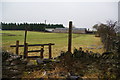
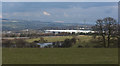
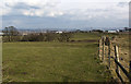
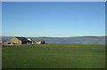
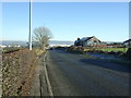
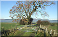
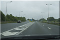
BB12 7LS is a small, tightly knit residential area in England, covering 540 square metres with a population of 1,543 people. Its compact size and moderate population density of 653 people per square kilometre suggest a quiet, community-oriented environment. The area’s historical roots are evident in its character: once a rural settlement, it now blends traditional housing with remnants of industrial heritage. Neighbouring Hapton, a village with a population of around 1,891, offers a broader context, extending from the River Calder to the Forest of Rossendale. Daily life here is shaped by its proximity to rail and retail amenities, including five nearby railway stations and local shops like Tesco Padiham. The area’s appeal lies in its balance of accessibility—within reach of Rawtenstall’s metro links—and a sense of tranquillity, with no major planning constraints like protected woodlands or AONBs. For buyers, BB12 7LS represents a compact, low-maintenance setting with historical depth and practical connectivity.
- Area Type
- Postcode
- Area Size
- 540 m²
- Population
- 1543
- Population Density
- 653 people/km²
The property market in BB12 7LS is characterised by a high rate of home ownership—68% of residents own their homes. This suggests a market skewed towards owner-occupied properties rather than rental demand, which may limit opportunities for investors. The area’s accommodation is primarily composed of houses, reflecting a traditional, low-density housing stock. Given the area’s small size and limited expansion potential, property availability is likely constrained, making it a niche market for buyers seeking established, stable homes. The absence of major planning constraints, such as protected landscapes or flood risks, further supports the appeal of owning property here. However, the compact nature of BB12 7LS means buyers should consider proximity to nearby towns like Padiham or Rawtenstall for broader amenities.
House Prices in BB12 7LS
Showing 1 properties
| Address | Type | Beds | Baths | Last Sale Price | Last Sale Date | |
|---|---|---|---|---|---|---|
| 2 Hampden Street, Hapton, BB12 7LS | house | - | - | £125,000 | Oct 2013 |
Energy Efficiency in BB12 7LS
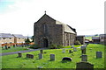
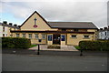
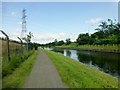
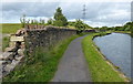
Living in BB12 7LS offers access to essential amenities within practical reach. Retail options include Tesco Padiham, Lidl Padiham, and Spar, providing everyday shopping convenience. The area’s proximity to the Leeds-Liverpool Canal adds a historical and recreational dimension, though specific parks or leisure facilities are not detailed in the data. The nearby rail stations, such as Hapton and Huncoat, enhance accessibility to cultural and commercial hubs. The village of Hapton itself, within close proximity, features historical sites like Hapton Tower and Hameldon Quarries, offering a blend of heritage and quiet rural living. While the data does not specify dining or entertainment venues, the presence of multiple retail outlets and transport links suggests a lifestyle that balances practicality with the potential for exploring nearby towns.
Amenities
Schools
| Rank | School | Type | Entry gender | Ages |
|---|
Explore more schools in this area
Go to Schools tabDemographics
The population of BB12 7LS has a median age of 47, with the majority of residents aged between 30 and 64 years. This suggests a mature, stable community with a strong presence of middle-aged adults. Home ownership is high at 68%, indicating a preference for long-term residency over rental properties. The area is predominantly composed of houses, reflecting a traditional housing stock rather than flats or apartments. The predominant ethnic group is White, which aligns with broader regional demographics. The age profile and home ownership rate imply a community focused on stability and family life, with fewer young families or transient populations. The absence of specific data on deprivation means the quality of life is inferred from the area’s low environmental risks and practical amenities.
Household Size
Accommodation Type
Tenure
Ethnic Group
Religion
Household Composition
Age
Household Deprivation
NS-SEC
Explore more demographic insights in this area
Go to Demographics tabPlanning
Planning Constraints
- Flood RiskPremium
- Ramsar Wetland SitesPremium
- Area of Outstanding Natural BeautyPremium
- Protected Nature ReservePremium
- Protected WoodlandPremium