Area Overview for BB12 6QE
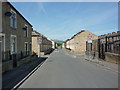
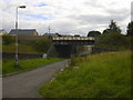
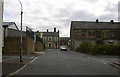
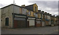
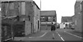
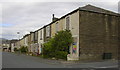
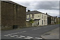
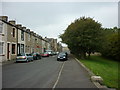
Photos of BB12 6QE
Area Information
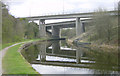
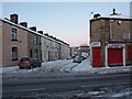
BB12 6QE lies within the Gannow Ward of Burnley, a small residential cluster near the Leeds and Liverpool Canal and the M65 motorway. With a population of 1,435 spread across 8,340 square metres, the area is densely populated yet retains a distinct character shaped by its industrial heritage. Historically a hub for coal and textile industries, Gannow’s development was influenced by the 1796 arrival of the Leeds and Liverpool Canal, which spurred growth at Gannow Wharf. Today, the area blends modern housing with remnants of its past, including Gannow Business Park, which repurposes Victorian cotton mills. Residents benefit from proximity to Burnley town centre, with rail links to major cities via nearby stations. The compact size of BB12 6QE means amenities and services are within walking or cycling distance, offering a mix of convenience and community-focused living.
- Area Type
- Postcode
- Area Size
- 8340 m²
- Population
- 1435
- Population Density
- 5688 people/km²
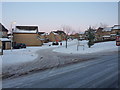
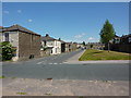
BB12 6QE is characterised by a housing stock that leans heavily towards owner-occupied homes, with 46% of properties owned by residents. The accommodation type is predominantly houses, which is unusual for a small postcode area but aligns with the broader trend in Burnley’s peripheral wards. This suggests a focus on family homes rather than apartments or flats. Given the area’s compact size, the property market is likely limited in scale, with limited scope for new builds. For buyers, this means a niche market where availability is constrained, and properties may be in high demand, particularly for those seeking a house in a historically rich area with access to rail links and retail amenities.
House Prices in BB12 6QE
Showing 52 properties
| Address | Type | Beds | Baths | Last Sale Price | Last Sale Date | |
|---|---|---|---|---|---|---|
| 58 Wordsworth Street, Burnley, BB12 6QE | Terraced | 1 | 1 | £70,000 | Feb 2025 | |
| 48 Wordsworth Street, Burnley, BB12 6QE | house | - | - | £70,000 | Apr 2024 | |
| 20 Wordsworth Street, Burnley, BB12 6QE | Terraced | 2 | 1 | £69,000 | Sep 2023 | |
| 44 Wordsworth Street, Burnley, BB12 6QE | Terraced | 2 | 1 | £65,000 | Jun 2023 | |
| 2 Wordsworth Street, Burnley, BB12 6QE | Terraced | 2 | 1 | £65,000 | May 2023 | |
| 34 Wordsworth Street, Burnley, BB12 6QE | house | - | - | £55,500 | Mar 2022 | |
| 60 Wordsworth Street, Burnley, BB12 6QE | Terraced | 2 | 1 | £50,000 | Feb 2022 | |
| 24 Wordsworth Street, Burnley, BB12 6QE | Terraced | 2 | 1 | £40,499 | Jun 2021 | |
| 16 Wordsworth Street, Burnley, BB12 6QE | house | - | - | £40,000 | Dec 2020 | |
| 28 Wordsworth Street, Burnley, BB12 6QE | Terraced | 2 | 1 | £39,999 | Feb 2020 |
Energy Efficiency in BB12 6QE
Residents of BB12 6QE enjoy a range of nearby amenities, including five retail outlets such as Farmfoods Rosehill and Spar, offering daily necessities. The area’s historical ties to the Leeds and Liverpool Canal are evident in Gannow Wharf, a site of industrial heritage, while Gannow Business Park provides modern workspace in repurposed Victorian mills. The Gannow Community Centre, supported by local initiatives, serves as a social hub. Rail stations provide easy access to Burnley and surrounding areas, and the compact layout ensures that shops, leisure spots, and transport are within practical reach, fostering a convenient yet community-oriented lifestyle.
Amenities
Schools
Residents of BB12 6QE have access to two key educational institutions. Ightenhill Nursery School provides early-years education, while Burnley Ightenhill Primary School, rated ‘good’ by Ofsted, caters to younger children. The absence of secondary schools in the immediate area means families may need to consider commuting to nearby towns for secondary education. The presence of a primary school with a positive rating is a significant draw for families, offering a foundation for local schooling. However, the lack of higher-level educational facilities nearby is a practical consideration for parents planning long-term in the area.
| Rank | School | Type | Entry gender | Ages |
|---|
Explore more schools in this area
Go to Schools tabDemographics
The population of BB12 6QE has a median age of 47, with the majority of residents aged between 30 and 64. This suggests a mature, stable community, likely with a strong presence of families and professionals. Home ownership stands at 46%, indicating a mix of owner-occupied properties and rental homes. The area is predominantly composed of houses, reflecting a preference for single-family dwellings over flats. The predominant ethnic group is White, aligning with broader trends in the Borough of Burnley. While the data does not specify deprivation levels, the high population density and historical housing expansion in the 1980s and 1990s suggest a balance of long-standing residents and newer developments.
Household Size
Accommodation Type
Tenure
Ethnic Group
Religion
Household Composition
Age
Household Deprivation
NS-SEC
Explore more demographic insights in this area
Go to Demographics tabPlanning
Planning Constraints
- Flood RiskPremium
- Ramsar Wetland SitesPremium
- Area of Outstanding Natural BeautyPremium
- Protected Nature ReservePremium
- Protected WoodlandPremium