Area Overview for BB12 6QB
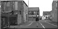
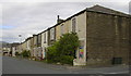
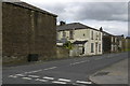
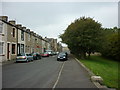
Photos of BB12 6QB
Area Information
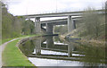
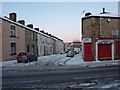
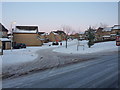
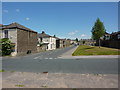
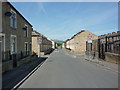
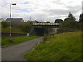
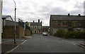
BB12 6QB is a small, densely populated residential area in the Borough of Burnley, Lancashire, situated north of Burnley town centre. It lies near the Leeds and Liverpool Canal, a historic waterway that once facilitated industrial activity, including coal transport via Gannow Wharf. The area is part of Gannow Ward, which has a population of around 1,619, though the specific postcode area has 1,435 residents spread across 3,456 square metres. This compact footprint means the community is tightly knit, with housing developments dating back to the 1980s and 1990s. The area’s character blends modern residential clusters with remnants of its industrial past, such as Gannow Business Park, which repurposes Victorian cotton mills. Proximity to the M65 motorway ensures easy access to Burnley and surrounding towns, while the canal offers a quieter, historic backdrop. Daily life here is shaped by its small-scale nature, with local amenities and transport links catering to a community predominantly aged 30–64.
- Area Type
- Postcode
- Area Size
- 3456 m²
- Population
- 1435
- Population Density
- 5688 people/km²
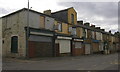
The property market in BB12 6QB is characterised by a 46% home ownership rate, with houses being the predominant accommodation type. This suggests a mix of owner-occupied homes and rental properties, though the small area size means the housing stock is limited. The presence of houses rather than flats or apartments indicates a more traditional, suburban layout. Given the high population density, the area’s small footprint likely limits housing availability, potentially increasing competition among buyers. The proximity to Gannow Business Park, which repurposes Victorian mills, adds a modern commercial element to the local landscape. For buyers, this means a focus on existing residential properties rather than new developments. The compact nature of the area also means that property values may be influenced by proximity to key amenities, such as schools and transport links, rather than large-scale infrastructure projects.
House Prices in BB12 6QB
Showing 24 properties
| Address | Type | Beds | Baths | Last Sale Price | Last Sale Date | |
|---|---|---|---|---|---|---|
| 12 Barleyfield Mews, Burnley, BB12 6QB | Flat | 2 | 1 | £71,000 | May 2025 | |
| 24 Barleyfield Mews, Burnley, BB12 6QB | Flat | 2 | 1 | £69,950 | May 2024 | |
| 17 Barleyfield Mews, Burnley, BB12 6QB | Flat | 2 | 1 | £65,000 | Oct 2023 | |
| 2 Barleyfield Mews, Burnley, BB12 6QB | Flat | - | - | £48,000 | Sep 2022 | |
| 10 Barleyfield Mews, Burnley, BB12 6QB | Flat | - | - | £60,000 | Sep 2022 | |
| 7 Barleyfield Mews, Burnley, BB12 6QB | Flat | - | - | £85,000 | Apr 2022 | |
| 15 Barleyfield Mews, Burnley, BB12 6QB | Flat | - | - | £68,000 | Dec 2020 | |
| 11 Barleyfield Mews, Burnley, BB12 6QB | Flat | - | - | £65,000 | Dec 2019 | |
| 1 Barleyfield Mews, Burnley, BB12 6QB | Flat | - | - | £65,000 | Aug 2019 | |
| 22 Barleyfield Mews, Burnley, BB12 6QB | Flat | - | - | £75,000 | Feb 2019 |
Energy Efficiency in BB12 6QB
The lifestyle in BB12 6QB is shaped by its proximity to retail, transport, and historical sites. Five retail outlets, including Farmfoods Rosehill and Spar, provide essential shopping options within practical reach. Three railway stations offer easy access to Burnley and beyond, enhancing connectivity for commuters. The Leeds and Liverpool Canal, a historic feature of the area, adds a recreational dimension, though specific parks or leisure facilities are not detailed in the data. The Gannow Community Centre, acquired in 2017, serves as a local hub for social activities. While the area lacks large-scale amenities, its compact nature ensures that daily needs are met through nearby services. The blend of modern retail, transport links, and historical elements creates a functional, if modest, lifestyle for residents.
Amenities
Schools
Residents of BB12 6QB have access to two nearby schools. Ightenhill Nursery School provides early years education, while Burnley Ightenhill Primary School offers primary education and holds a ‘good’ Ofsted rating. These institutions cater to younger families, with the primary school’s rating indicating a satisfactory standard of education. However, the absence of secondary schools in the immediate area means families may need to travel further for secondary education. The presence of a nursery and a primary school within walking distance is a significant advantage for parents seeking convenience. The mix of school types reflects the area’s role as a residential hub for families, though the lack of higher education facilities nearby could be a limitation for those requiring a full range of educational options.
| Rank | School | Type | Entry gender | Ages |
|---|
Explore more schools in this area
Go to Schools tabDemographics
The population of BB12 6QB is 1,435, with a density of 415,187 people per square kilometre—among the highest in England. The median age is 47, with the most common age range being adults aged 30–64. Home ownership accounts for 46% of households, suggesting a mix of owner-occupied and rental properties. The predominant accommodation type is houses, reflecting a suburban rather than high-rise profile. The ethnic composition is largely White, with no specific data on other groups. The high population density, combined with the median age, indicates a mature, settled community. However, the lack of detailed diversity metrics means the area’s social fabric is not fully quantified. The 46% home ownership rate implies that nearly half of residents rent, which may influence the local property market’s dynamics.
Household Size
Accommodation Type
Tenure
Ethnic Group
Religion
Household Composition
Age
Household Deprivation
NS-SEC
Explore more demographic insights in this area
Go to Demographics tabPlanning
Planning Constraints
- Flood RiskPremium
- Ramsar Wetland SitesPremium
- Area of Outstanding Natural BeautyPremium
- Protected Nature ReservePremium
- Protected WoodlandPremium