Area Overview for BB11 1QD
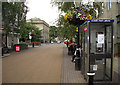
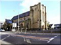
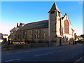
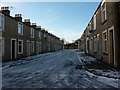
Photos of BB11 1QD
Area Information
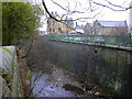
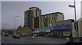
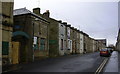
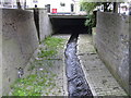
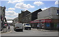
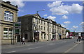
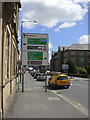
BB11 1QD is a small residential postcode in Burnley, England, nestled just north of the town centre. With a population of 2,054, it is a tightly knit area defined by pre-1919 terraced housing, former factories, and a strong historical connection to Burnley’s industrial past. The area is bounded by the M65 motorway to the west and the East Lancashire railway line to the east, offering easy access to nearby towns and cities. Daily life here is shaped by its proximity to Burnley’s core, with a mix of practical amenities and a community character influenced by its high Asian British population. The area’s compact size means residents are close to essential services, though its small footprint also limits housing diversity. A walk through the streets reveals a blend of historic architecture and modern retail, with local landmarks like the Leeds and Liverpool Canal adding a touch of heritage. For those seeking a quiet yet connected location, BB11 1QD offers a snapshot of northern England’s evolving urban fabric.
- Area Type
- Postcode
- Area Size
- Not available
- Population
- 2054
- Population Density
- 2800 people/km²
The property market in BB11 1QD is small-scale and dominated by rental properties, with only 27% of homes owned by residents. The area’s housing stock consists almost entirely of houses, specifically terraced homes built between 1860 and 1930. This limited supply means the market is highly competitive, with few new developments. The compact nature of the postcode suggests that buyers must look beyond the immediate area for alternative options, though the proximity to Burnley’s town centre may offer broader choices. The pre-1919 construction dates mean many properties are older, potentially requiring renovation. For those seeking owner-occupied homes, the low home ownership rate indicates a strong rental demand, which could affect property values and availability. Buyers should consider the area’s historical character and potential for long-term investment in a community with a distinct demographic profile.
House Prices in BB11 1QD
No properties found in this postcode.
Energy Efficiency in BB11 1QD
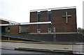
Life in BB11 1QD is shaped by its proximity to practical amenities and a distinct cultural environment. Nearby retail options include Iceland Burnley, M&S Burnley, and Aldi Burnley, offering everyday shopping needs. The area’s rail network, with stations like Burnley Central and Burnley Manchester Road, provides access to Burnley’s town centre and regional transport hubs. The high Asian British population contributes to a culturally rich community, with landmarks such as the Burnley Islamic Cultural Centre and Shah Jalal Mosque (under construction) reflecting the area’s heritage. Locally, Daneshouse FC offers recreational opportunities, while the Leeds and Liverpool Canal adds a touch of historical interest. Though the area lacks large parks, its compact layout ensures residents are close to essential services and community hubs, creating a convenient but tightly focused lifestyle.
Amenities
Schools
Residents of BB11 1QD have access to two key educational institutions. Burnley St Peter’s Church of England Primary School, rated ‘good’ by Ofsted, provides primary education for young children, while Burnley College offers sixth-form education. This combination means families can access both primary and post-16 education within the area, though secondary schooling would require commuting to other parts of Burnley. The presence of a sixth-form college suggests the area supports older students pursuing further education, but the absence of secondary schools nearby may be a consideration for families with children needing a full range of schooling. The ‘good’ rating at the primary school indicates a reliable foundation for early education, though parents should verify additional details about transport links and school capacity for older children.
| Rank | School | Type | Entry gender | Ages |
|---|
Explore more schools in this area
Go to Schools tabDemographics
The community in BB11 1QD is predominantly composed of adults aged 30–64, with a median age of 22, reflecting a mix of working-age residents and younger families. Home ownership is low, with only 27% of households owning their homes, indicating a rental-heavy market. The area is characterised by houses rather than flats, though the housing stock is largely terraced, built between 1860 and 1930. The predominant ethnic group is Asian British, making up 90.85% of the population, with 80% identifying as Muslim according to the 2021 census. This demographic profile places the area among the 5% most deprived wards in the UK, with high child poverty (two-thirds of children) and elevated crime rates (339.8 per 1,000 in 2007). These factors influence local quality of life, with residents often facing challenges related to economic opportunity and safety, despite the area’s strong cultural identity and community ties.
Household Size
Accommodation Type
Tenure
Ethnic Group
Religion
Household Composition
Age
Household Deprivation
NS-SEC
Explore more demographic insights in this area
Go to Demographics tabPlanning
Planning Constraints
- Flood RiskPremium
- Ramsar Wetland SitesPremium
- Area of Outstanding Natural BeautyPremium
- Protected Nature ReservePremium
- Protected WoodlandPremium