Area Overview for BB11 1EN
Photos of BB11 1EN
Area Information
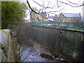
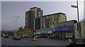
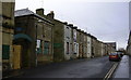
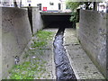
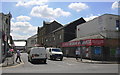
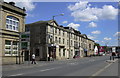
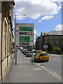
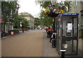
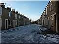
BB11 1EN is a small, tightly knit residential postcode area in Burnley, Lancashire, with a population of 2054. Situated just north of Burnley’s town centre, it is defined by pre-1919 terraced housing, former factories, and mills, reflecting the area’s industrial heritage. The layout, shaped by the M65 motorway to the west and the Leeds and Liverpool Canal to the east, creates a compact urban district with a distinct character. Daily life here is influenced by its proximity to Burnley’s rail network and retail hubs, offering practical access to amenities. The area’s demographics reveal a young population, with a median age of 22, though the most common age group is adults aged 30–64. This mix suggests a community balancing younger residents with families and long-term residents. The high proportion of Asian or Asian British residents, predominantly Muslim, adds cultural diversity to the neighbourhood. While the area’s historical roots in terraced housing and industrial sites remain visible, modern connectivity and transport options make it a practical choice for those seeking a residential base with access to Burnley’s broader infrastructure.
- Area Type
- Postcode
- Area Size
- Not available
- Population
- 2054
- Population Density
- 2800 people/km²
The property market in BB11 1EN is characterised by a low home ownership rate of 27%, indicating that most properties are likely rented rather than owner-occupied. The accommodation type is predominantly houses, though the area’s small size and historical development suggest limited housing stock. This combination points to a rental-focused market, with limited opportunities for buyers seeking long-term ownership. The terraced housing built between 1860 and 1930, alongside former industrial buildings, reflects a legacy of working-class housing. For buyers, this means a constrained market with few new developments, and properties may be more suited to those prioritising affordability over investment potential. The proximity to Burnley’s rail network and retail areas could enhance the appeal of rental properties for commuters, but the area’s deprivation and safety concerns may deter some buyers.
House Prices in BB11 1EN
No properties found in this postcode.
Energy Efficiency in BB11 1EN
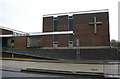
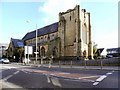
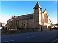
Residents of BB11 1EN have access to a range of local amenities within practical reach. Retail options include Iceland Burnley, M&S Burnley, and Tesco Burnley, providing essential shopping and convenience stores. The area’s rail stations—Burnley Manchester Road, Burnley Central, and Burnley Barracks—offer direct links to regional transport hubs, enhancing connectivity for commuters. While the data does not list parks or leisure facilities explicitly, the proximity to the Leeds and Liverpool Canal and historical sites like Old Hall Farm suggest opportunities for outdoor activities. The presence of the Burnley Islamic Cultural Centre and Shah Jalal Mosque (under construction) adds to the community’s cultural fabric. The compact nature of the area means residents can access daily necessities without long journeys, though the lack of detailed information on parks or recreational spaces may require further local investigation.
Amenities
Schools
Residents of BB11 1EN have access to two key educational institutions. Burnley St Peter’s Church of England Primary School, a primary school with a good Ofsted rating, provides early education for local children. Nearby, Burnley College offers sixth-form education, catering to older students pursuing further studies. This mix of primary and post-16 education ensures families can access schooling from early years through to higher education within the area. The presence of a well-rated primary school is a significant advantage, though the absence of secondary schools means students may need to travel to Burnley’s town centre or beyond for secondary education. The sixth-form provision at Burnley College supports local students seeking advanced qualifications, reducing the need for long commutes.
| Rank | School | Type | Entry gender | Ages |
|---|
Explore more schools in this area
Go to Schools tabDemographics
The community in BB11 1EN is predominantly composed of adults aged 30–64, with a median age of 22, indicating a mix of younger and older residents. Home ownership is relatively low at 27%, suggesting a rental market dominates the area. The accommodation type is primarily houses, though the small population and limited housing stock imply a constrained market. The predominant ethnic group is Asian_total, with 90.85% of the population identifying as Asian or Asian British, predominantly Muslim (80% per the 2021 census). This demographic profile places BB11 1EN among the UK’s 5% most deprived wards, with high child poverty (two-thirds of children) and elevated crime rates (339.8 per 1,000 in 2007). These factors influence the area’s quality of life, with residents facing challenges in access to services and safety. The high proportion of Muslim residents also shapes the cultural landscape, reflected in local institutions like the Burnley Islamic Cultural Centre.
Household Size
Accommodation Type
Tenure
Ethnic Group
Religion
Household Composition
Age
Household Deprivation
NS-SEC
Explore more demographic insights in this area
Go to Demographics tabPlanning
Planning Constraints
- Flood RiskPremium
- Ramsar Wetland SitesPremium
- Area of Outstanding Natural BeautyPremium
- Protected Nature ReservePremium
- Protected WoodlandPremium