Area Overview for BB10 4PE
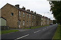
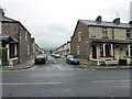
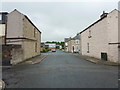
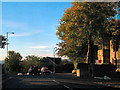
Photos of BB10 4PE
Area Information
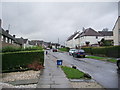
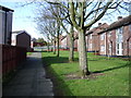
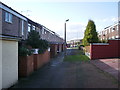
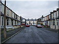
Living in BB10 4PE means choosing a specific residential cluster in the borough of Burnley, Lancashire. This postcode covers a small area of 5,981 square metres, offering a compact environment for those seeking proximity to local hubs. The location sits within Brunshaw, an electoral ward in the Borough of Burnley, reflecting a structured local government history that dates back to the 1974 reorganisation. You will find yourself in a setting where the population stands at 1,555 residents, creating a tight-knit community feel. The area density reaches 259,981 people per square kilometre, indicating a high concentration of housing within this specific cluster. While the postcode designation is BB10 4PE, research confirms the coordinates correspond to the broader Brunshaw ward structure. Daily life here revolves around practicality and efficiency, as the small size of the area brings residents into close contact with immediate neighbours and local facilities. This distinction makes BB10 4PE a unique micro-environment within the larger urban sprawl of Burnley, rather than a sprawling suburb. The layout supports a lifestyle where amenities and transport links are within a short walk or drive, removing the need for extensive daily commuting to reach essential services.
- Area Type
- Postcode
- Area Size
- 5981 m²
- Population
- 1555
- Population Density
- 2780 people/km²
The property market in BB10 4PE is characterised by a significant owner-occupier presence, with 55 per cent of residents owning their homes. This indicates a stable market where long-term residents form the bulk of the tenanted and owner groups. Houses are the main accommodation type throughout this postcode, meaning you will encounter terraced, semi-detached, and detached properties typical of established Lancashire towns. Buyers looking at BB10 4PE should expect a stock that is largely comprised of older, character homes rather than modern speculative builds. The small area size of 5,981 square metres limits the sheer volume of available listings, which can make competition specific but the market reflective of local demand. Given the high home ownership rate, purchasing here often means joining an established household structure rather than displacing tenants. The density of 259,981 people per square kilometre suggests that available properties may be snapped up quickly once listed, as many current owners wish to downsize or relocate. Investors should note that the area functions primarily as a residential zone, lacking significant commercial development within the immediate cluster. This focus on housing means price fluctuations will mirror broader trends in the Burnley borough rather than being driven by local retail expansion.
House Prices in BB10 4PE
Showing 16 properties
| Address | Type | Beds | Baths | Last Sale Price | Last Sale Date | |
|---|---|---|---|---|---|---|
| 97 Culshaw Street, Burnley, BB10 4PE | Semi-detached | 4 | 2 | £220,000 | May 2024 | |
| 83 Culshaw Street, Burnley, BB10 4PE | house | 4 | - | £140,000 | Jan 2021 | |
| 85 Culshaw Street, Burnley, BB10 4PE | Terraced | - | - | £100,000 | Nov 2019 | |
| 93 Culshaw Street, Burnley, BB10 4PE | Terraced | 2 | 1 | £86,000 | Sep 2019 | |
| 46 Culshaw Street, Burnley, BB10 4PE | house | - | - | £56,000 | Dec 2011 | |
| 103 Culshaw Street, Burnley, BB10 4PE | house | - | - | £99,500 | Oct 2011 | |
| 91 Culshaw Street, Burnley, BB10 4PE | Terraced | 2 | 1 | £70,000 | Feb 2011 | |
| 101 Culshaw Street, Burnley, BB10 4PE | Semi-detached | - | - | £112,000 | May 2006 | |
| 48 Culshaw Street, Burnley, BB10 4PE | Semi-detached | 3 | 1 | £119,950 | Mar 2006 | |
| 54 Culshaw Street, Burnley, BB10 4PE | Semi-detached | - | - | £55,500 | Nov 2002 |
Energy Efficiency in BB10 4PE
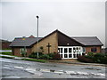
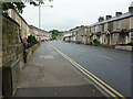
Daily life in BB10 4PE is shaped by immediate access to essential amenities within practical reach. Retail is well-covered with five convenient options, notably including Tesco Burnley, Spar, and another Spar location. These supermarkets allow you to handle weekly grocery shopping and household needs without long travel times. Transport options are equally accessible, with five railway stations nearby, including Burnley Central, Burnley Manchester Road, and Burnley Barracks. You can reach these stations on foot or a short drive, linking directly to national rail networks for commuting to Manchester, Leeds, or London. While the area is residential, these amenities ensure that diverse needs are met efficiently. The small population of 1,555 means that local shops remain focused on serving residents rather than attracting large crowds of tourists. This creates a supportive environment where local businesses know their customers personally. The presence of five retail outlets and five rail stations within this 5,981 square metre area highlights the convenience factor of living in BB10 4PE. You can combine a suburban lifestyle with urban transport links, enjoying the best of both worlds. The nearby amenities mean that evenings and weekends involve short trips to the local stores rather than crossing the city to find them.
Amenities
Schools
| Rank | School | Type | Entry gender | Ages |
|---|
Explore more schools in this area
Go to Schools tabDemographics
The community in BB10 4PE is defined by a mature population, with a median age of 47 years. Most residents fall into the adult age range between 30 and 64 years, suggesting a demographic that values stability over the volatility of early adulthood. Home ownership levels stand at 55 per cent, meaning slightly more than half of the residents own their property outright or have a mortgage. The remaining households include tenants or those in other tenure types. Houses form the predominant accommodation type in this postcode, aligning with the preferences of the established adult population. The ethnic makeup is predominantly White, which reflects the traditional demographic profile of the Burnley region. Because the median age is higher than the national average, you will likely encounter neighbours who have been in their homes for decades. This stability contributes to a consistent community character, free from the rapid turnover associated with university towns or new build estates. The high density of 259,981 people per square kilometre ensures that facilities are well-used, fostering a lively local atmosphere despite the small total population of 1,555. Families and empty nesters both find common ground in this area, shaping a neighbourhood that prioritises quiet domestic life over nightlife.
Household Size
Accommodation Type
Tenure
Ethnic Group
Religion
Household Composition
Age
Household Deprivation
NS-SEC
Explore more demographic insights in this area
Go to Demographics tabPlanning
Planning Constraints
- Flood RiskPremium
- Ramsar Wetland SitesPremium
- Area of Outstanding Natural BeautyPremium
- Protected Nature ReservePremium
- Protected WoodlandPremium