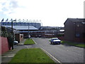
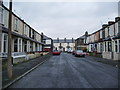
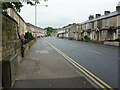
Area Overview for BB10 4EN
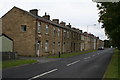
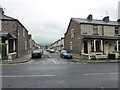
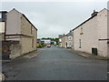
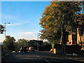
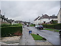
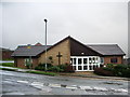
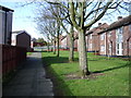
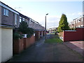
Photos of BB10 4EN
Area Information
The postcode BB10 4EN defines a specific residential cluster within Brunshaw, a ward in the Borough of Burnley. This small area covers just 3407 square metres and holds a population of 1598 residents. Living here means being part of a tightly knit pocket located at coordinates 53.786809, -2.224594 in North West England. The local government district operates under the unitary authority structure established after the 1974 reorganisation. You are situated in an environment where space is premium, with nearly 469,064 people per square kilometre at the broader density level reflected here. Residents enjoy the benefits of a defined ward that forms part of the larger Burnley landscape. Daily life revolves around this concentrated community hub which sits within Lancashire. The area represents a slice of the historic town where local governance and housing coincide in a small footprint. Prospective buyers consider this distinct postcode when looking for homes in BB10 4EN or the wider postcode area.
- Area Type
- Postcode
- Area Size
- 3407 m²
- Population
- 1598
- Population Density
- 9552 people/km²
Homes in BB10 4EN are characterised by a stock that heavily favours houses over other property types. The area reflects a traditional housing model where ownership rates sit at 60%, indicating a solid base of owner-occupiers. This high proportion of ownership suggests the market is dominated by long-term residents rather than transient tenants. When you search for properties here, expect to find bedsit-type statistics are absent and houses remain the standard. The small footprint of 3407 square metres means the housing stock is likely concentrated and uniform. Buyers looking at this postcode should understand the scarcity of land which drives density up to specific local levels. The 60% ownership figure signals a stable market where sales occur between owners rather than high volumes of new trickle-down to renters. This profile appeals to those who prefer the security of buying a house and establishing roots in Brunshaw. The accommodation type data confirms that you will primarily encounter detached or semi-detached structures in this specific cluster.
House Prices in BB10 4EN
Showing 24 properties
| Address | Type | Beds | Baths | Last Sale Price | Last Sale Date | |
|---|---|---|---|---|---|---|
| 56 Mitella Street, Burnley, BB10 4EN | Terraced | 4 | 1 | £115,000 | Sep 2025 | |
| 23 Mitella Street, Burnley, BB10 4EN | Terraced | 3 | 1 | £95,000 | Aug 2025 | |
| 21 Mitella Street, Burnley, BB10 4EN | Terraced | 3 | 1 | £79,000 | Sep 2024 | |
| 66 Mitella Street, Burnley, BB10 4EN | Terraced | 3 | 1 | £62,500 | Nov 2023 | |
| 54 Mitella Street, Burnley, BB10 4EN | Terraced | 3 | 1 | £65,000 | Aug 2023 | |
| 52 Mitella Street, Burnley, BB10 4EN | Retail | 3 | 1 | £80,000 | Jul 2022 | |
| 40 Mitella Street, Burnley, BB10 4EN | Terraced | 3 | - | £76,188 | Jun 2022 | |
| 27 Mitella Street, Burnley, BB10 4EN | house | - | - | £80,000 | Jan 2022 | |
| 19 Mitella Street, Burnley, BB10 4EN | Terraced | 2 | 1 | £70,000 | Feb 2020 | |
| 38 Mitella Street, Burnley, BB10 4EN | Terraced | 3 | - | £84,000 | Dec 2018 |
Energy Efficiency in BB10 4EN
Your daily lifestyle in BB10 4EN benefits from specific amenities within practical reach of the residential cluster. Five retail outlets serve your shopping needs, including Aldi Brunshaw, Spar, and Tesco Burnley. These venues provide everything from fresh groceries to household essentials within easy distance. Transport links are equally accessible with five railway stations noted as notable nearby options. Burnley Central Railway Station, Burnley Manchester Road Railway Station, and Burnley Barracks Railway Station act as key gateways to the wider network. Living in BB10 4EN means you have immediate access to these transport hubs for commuting to Manchester or other northern cities. The presence of multiple stations reduces dependency on private vehicles for daily travel. You can walk to Tesco Burnley for essentials or step onto a train at Burnley Central for longer journeys. Shopping and transport infrastructure surrounds this small postcode, ensuring convenience does not suffer despite the limited living space.
Amenities
Schools
| Rank | School | Type | Entry gender | Ages |
|---|
Explore more schools in this area
Go to Schools tabDemographics
The community in BB10 4EN centres on adults between 30 and 64 years old, reflecting a maturity in the neighbourhood. The median age stands at 47, confirming that this is a settled area rather than a hub for young families or students. Home ownership defines the social structure, with 60% of residents owning their properties outright or via mortgage. Houses make up the predominant accommodation type, suggesting larger dwellings rather than apartments or flats. The predominant ethnic group is White, creating a specific cultural make-up for those seeking homes in this cluster. This demographic profile suits empty nesters, established couples, or working professionals who value stability. A 60% ownership rate indicates a lower reliance on the private rental sector compared to student cities. The age distribution ensures that local shops and services cater to an adult demographic with established lifestyles. When you evaluate schools near BB10 4EN, remember the resident base is already comprised of adults with children of varying ages.
Household Size
Accommodation Type
Tenure
Ethnic Group
Religion
Household Composition
Age
Household Deprivation
NS-SEC
Explore more demographic insights in this area
Go to Demographics tabPlanning
Planning Constraints
- Flood RiskPremium
- Ramsar Wetland SitesPremium
- Area of Outstanding Natural BeautyPremium
- Protected Nature ReservePremium
- Protected WoodlandPremium