Area Overview for Barton and Pooley Bridge
Photos of Barton and Pooley Bridge


Area Information
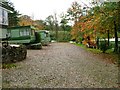
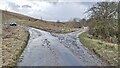
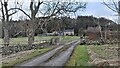
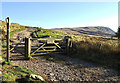
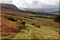
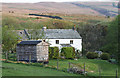
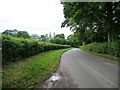
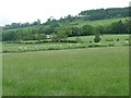
Living in Barton and Pooley Bridge offers a distinctly rural existence within Westmorland and Furness. This civil parish occupies 18.3 km² on the edge of the Lake District National Park in Cumbria. The area encompasses the village of Pooley Bridge, the hamlet of Barton, part of Ullswater lake, and extends south to Loadpot Hill. Historical records indicate the modern civil parish renamed itself from Barton on 1 April 2019. Previously, the region included parts of Patterdale, Yanwath, Eamont Bridge, Sockbridge and Tirril. Daily life remains defined by agriculture until the 19th century, though tourism increasingly shapes the local economy. You will find 37 listed buildings scattered across the landscape, including the Grade I St Michael's Church with its 12th-century origins and Norman tower. A medieval parish church of St Michael stands restored from 1904, while St Paul's chapel was built between 1867 and 1868. The community benefits from a pier at Pooley Bridge and the presence of Parkin Memorial Hall built in 1911. Historical assets include a free endowed grammar school founded in 1648 and a vicarage constructed in 1637 by Reverend Lancelot Dawes. While fish markets and livestock fairs ceased operations in the 19th century, paddle steamers have operated since 1859. You can expect a population density of 14 per square kilometre based on a 2011 population of 238. The postcode area CA10 2LZ sits near coordinates 54.589929, -2.843834.
- Area Type
- Parish
- Area Size
- 18.3 km²
- Population
- Not available
- Population Density
- Not available
Demographics
The community in Barton and Pooley Bridge reflects an older settlement pattern. The median age stands at 70 years, making this one of the oldest residential areas in the country. Age data indicates a total population structure without specific sub-range breakdowns in the current records. You will find that 56% of residents own their homes outright, suggesting strong community stability among local inhabitants. Household composition data is recorded as total figures without detailed breakdowns of family sizes or single-person households. Accommodation types are similarly aggregated under total categories rather than specific dwelling classifications. The area maintains a predominantly rural character with low population density. Ethnic group data is available only as total figures, offering no insight into specific diversity metrics within the parish. Religious affiliation is also recorded as a total without further demographic segmentation. These aggregate statistics confirm a static, long-established community. The higher median age correlates with a population defined historically by agriculture and dependent on the slow shift towards tourism after the 19th century. You should anticipate a neighbourhood where life moves at a traditional pace. Standard security precautions are advisable given the medium crime risk environment. The demographic profile suggests an area where established families and retired residents maintain the village feel. No data exists regarding specific deprivation levels.
Household Size
Accommodation Type
Tenure
Ethnic Group
Religion
Household Composition
Age
Household Deprivation
NS-SEC
Explore more demographic insights in this area
Go to Demographics tabPlanning
Planning Constraints
- Flood RiskPremium
- Ramsar Wetland SitesPremium
- Area of Outstanding Natural BeautyPremium
- Protected Nature ReservePremium
- Protected WoodlandPremium