Area Overview for Bampton
Photos of Bampton


Area Information
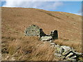
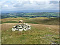
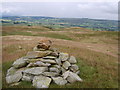
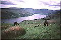
Living in Bampton means residing in a civil parish on the edge of the Lake District National Park. You will find Bampton situated in the Westmorland and Furness unitary authority area of Cumbria, approximately two miles north-north-east of Haweswater Reservoir. The parish encompasses an area of 44.2 km², incorporating distinct villages including Bampton Grange, Butterwick, and Bomby. This locale sits on the River Lowther, about four miles north-west of Shap railway station. The landscape is defined by hill farming and a historic character dating back to the 13th century when manors were named after Patrick de Culwen and Henry de Cundale. Today, the community focuses around practical facilities such as The Mardale Inn, Bampton Valley Stores, and Memorial Hall. The site of a traditional red telephone box featured in the 1987 film *Withnail & I* adds to the area's visual history. You are walking distance from notable landmarks like St Patrick's Church in Bampton Grange, which was rebuilt in 1726. The parish includes over 10,925 acres of land, with Bampton Common being a significant feature. Daily life here centres on a quiet rural existence, surrounded by the wooded areas near Firth Woods and the proximity of Haweswater Beck. This setting offers a peaceful backdrop for residents who prioritise natural surroundings over urban convenience.
- Area Type
- Parish
- Area Size
- 44.2 km²
- Population
- Not available
- Population Density
- Not available
Demographics
The community profile of Bampton reflects its status as a settled rural parish. The median age across the area is 70 years, indicating a significantly older population compared to national averages. When looking at the accommodation, 56% of households report ownership of their homes. This high ownership figure suggests the village functions as a long-term home for residents rather than a transient rental market. The demographic data does not break down specific age ranges, ethnicity, or religious affiliations, but the overall median age points towards a mature community. Bampton was historically an ancient parish in West Ward, Westmorland, with its population dynamics shaped by the construction of the Haweswater dam which temporarily boosted numbers to 1,011 residents in 1931. The economy has traditionally relied on hill farming, evidenced by the formation of the Bampton Sheep Association in 1876. Modern life here revolves around local traders and services. The community feel is described as small and peaceful, centring on community-owned venues like The Mardale Inn. You should expect a hierarchy where property ownership is the dominant household model. The historical consolidation of land under the earls of Lonsdale by the early 19th century also shaped the current density of residents in this civil parish.
Household Size
Accommodation Type
Tenure
Ethnic Group
Religion
Household Composition
Age
Household Deprivation
NS-SEC
Explore more demographic insights in this area
Go to Demographics tabPlanning
Planning Constraints
- Flood RiskPremium
- Ramsar Wetland SitesPremium
- Area of Outstanding Natural BeautyPremium
- Protected Nature ReservePremium
- Protected WoodlandPremium
- Crime RiskPremium