Area Overview for Balderstone & Kirkholt Ward
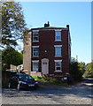
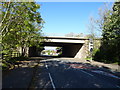
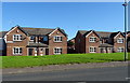
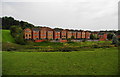
Photos of Balderstone & Kirkholt Ward
Area Information
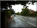
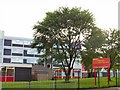
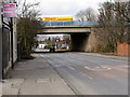
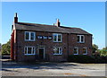
Balderstone and Kirkholt Ward is a distinct residential district located within the Metropolitan Borough of Rochdale in Greater Manchester. This area covers a compact footprint of 4.2 square kilometres, situated south-west of Rochdale town centre. You will find this locality defined by its historical layers and current residential focus. The ward combines the historic setting of Balderstone, known for its association with Balderstone Hall Estate and the original Balderstone Park, with Kirkholt. Kirkholt features a significant council housing estate developed during the 1950s. Life here offers a mix of heritage and post-war urban planning. The population density supports a community feel rooted in these specific locales. Balderstone Park, formerly part of the hall estate, remains a notable feature within the ward boundaries. While the area lacks large designated protected woodlands or Areas of Outstanding Natural Beauty, it does contain protected nature reserves as part of its green infrastructure. Residents live amidst Grade II listed buildings such as Brick-Built House at Chadwick Fold and Broad Shaw Farmhouse. These structures add historic character to the modern streets. You are looking at ward boundaries that hold specific legal designations and a directly measurable area size. Knowing the landholdings helps you understand the development constraints and open space available in this specific part of Rochdale.
- Area Type
- District Borough Unitary Ward
- Area Size
- 4.2 km²
- Population
- Not available
- Population Density
- Not available
Demographics
The community profile of Balderstone and Kirkholt Ward presents a notably older population compared to many other urban areas. The median age in this ward is 70, indicating a settlement with a significantly older demographic. Most households appear to consist of elderly residents, as suggested by the data highlighting age as the primary demographic feature. With a median age of 70, the typical residence is likely occupied by retirees or long-term residents rather than young professionals or growing families. This demographic reality shapes the daily rhythm of the neighbourhood. Home ownership rates stand at 41% for the area. This figure suggests that while nearly half of the homes in Balderstone and Kirkholt Ward are owned outright, the other half are likely rented or shared ownership properties. Given the historical context of the Kirkholt estate and the older population, you might find a mixture of leasehold council housing and privately owned bungalows or low-rise blocks. The household composition data points towards a settled demographic without the volatility often seen in younger urban zones. You should expect a community where residents have long-term ties to their homes. The high median age means services and facilities tend to cater to an older demographic. This data supports the observation that you are entering a mature, settled environment where change happens gradually.
Household Size
Accommodation Type
Tenure
Ethnic Group
Religion
Household Composition
Age
Household Deprivation
NS-SEC
Explore more demographic insights in this area
Go to Demographics tabPlanning
Planning Constraints
- Flood RiskPremium
- Ramsar Wetland SitesPremium
- Area of Outstanding Natural BeautyPremium
- Protected Nature ReservePremium
- Protected WoodlandPremium
- Crime RiskPremium