Area Overview for Ashton Hayes and Horton-cum-Peel
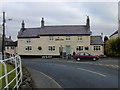
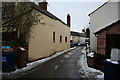
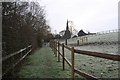
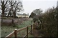
Photos of Ashton Hayes and Horton-cum-Peel


Area Information
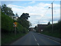
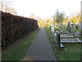
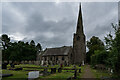
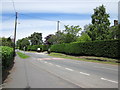
Living in Ashton Hayes and Horton-cum-Peel offers a distinct rural experience within the unitary authority of Cheshire West and Chester. This civil parish, which covers 7.0 km², enshrines three specific villages: Ashton Hayes, Horton-cum-Peel, and parts of Mouldsworth. You will find the location approximately 8 miles east of Chester, accessible via the B5393 road, placing it directly near the expansive grounds of Delamere Forest. The area encompasses a population of about 1300 residents living in 420 households. This relatively low density contributes to a quiet atmosphere that differs markedly from the busy urban centres of North West England. The parish itself was formed on 1 April 2015 by merging the former separate townships and parishes of Ashton and Horton-cum-Peel, each having existed since 1866. Daily life here is shaped by a strong community feel supported by the active Ashton Hayes Parish Council. You will encounter significant historical features alongside modern living, ranging from a medieval pottery kiln site discovered in Smithy House in 1933 to the Grade II* listed Peel Hall, built in 1637. The community underwent notable change in the 1960s when the population more than doubled due to new housing estates. Today, the landscape remains defined by farmland and the proximity to green spaces. Prospective residents appreciate the balance between countryside access and reasonable distance from larger town facilities. This setting provides a grounded lifestyle where the heritage of the Vernon and Mainwaring families continues to influence the character of the streets. ### The community profile of Ashton Hayes and Horton-cum-Peel reflects a mature population with a median age of 70 years. This age demographic indicates that the area is primarily settled by older households rather than young professionals or families with small children. While the most common age range category is simply listed as "Total" in available records, the high median age suggests a prevalence of retirement-age residents or those nearing retirement. House ownership stands at a solid 78% within the parish. This high rate of ownership implies that the majority of residents have built their equity over time and are less likely to be tenants seeking short-term rentals. Accommodation data for the total area confirms the stability of the housing stock without specifying breakdowns by bedroom count or tenure other than the ownership percentage. The ethnic composition and religious affiliation of the total population are noted in the records but are not detailed with specific breakdowns. Despite these general categorisations, the area maintains a cohesive identity rooted in its long history. The population of roughly 1300 people spread across 420 households creates a tight-knit environment. This demographic structure means local services and community events likely cater to the needs of an older demographic. You will find a neighbourhood where long-term residents know each other well, fostering a sense of familiarity. The area does not signal rapid demographic shifts or high influxes of new residents, supporting a predictable and calm living environment for those who value community consistency. ### The property market in Ashton Hayes and Horton-cum-Peel is characterised by dominant home ownership, with 78% of the population owning their dwelling. This indicates a estate where residents have settled permanently rather than cycling through short-term tenancies. The high ownership rate of nearly four out of five households suggests that the current stock is largely comprised of family homes owned by their occupants. With approximately 420 households in a 7.0 km² footprint, the housing supply is limited and tightly held by the community itself. This scarcity creates a market where available homes for sale are often rare, as most properties are not owned by rental agencies but by individuals wishing to move internationally or locally. Accommodation types align with the rural village character, featuring a mix of historical character properties and estates built during the demographic expansion of the 1960s. Notable listed buildings such as Peel Hall and Ashton Hall Farmhouse add to the architectural diversity, offering unique properties for those with renovation budgets. The merger of Ashton and Horton-cum-Peel parishes into one civil entity in 2015 has streamlined local governance but has not fundamentally altered the underlying housing stock. Buyers looking at Ashton Hayes and Horton-cum-Peel should expect to compete with owners in the second-hand market rather than dealing with new builds or developer plots. The low population density of 1300 people across the parish means that new development is unlikely in the near future. Consequently, the values of homes in this area are supported by the scarcity of significantly affordable or brand-new properties elsewhere in the region. ### Digital connectivity for residents of Ashton Hayes and Horton-cum-Peel varies between fixed-line internet and mobile networks. Mobile coverage scores high at 82 out of 100, indicating that you can expect good signal strength for smartphones and data usage throughout much of the parish. However, fixed broadband quality scores 30 out of 100. This lower score suggests that while you can make calls and use data on your phone effectively, downloading large files or hosting video calls may experience slower speeds compared to urban counterparts. This disparity means living in Ashton Hayes and Horton-cum-Peel requires consideration of your work needs. If you rely heavily on high-speed fibre for video conferencing or heavy file transfers, the current infrastructure may be restrictive. The area is located approximately 8 miles east of Chester on the B5393 road, with no railway stations within the parish itself. This hinterland location near Delamere Forest means daily commutes require car ownership or provision within the village. The absence of public transport hubs necessitates that you factor travel time into your daily routine. For residents working remotely, the good mobile coverage helps mitigate some issues, but the fixed broadband limitation remains a constraint for heavy internet users. Homes in this area sit in a zone where mobile technology performs well, but traditional wired internet infrastructure lags behind national averages. You should verify specific street-level broadband speeds with providers before purchasing, as the general score of 30 reflects an average across the 7.0 km² area. ### Safety and environmental constraints in Ashton Hayes and Horton-cum-Peel present a largely favourable picture with minor exceptions. The area holds a low crime risk, achieving a safety score of 88 out of 100. This high rating confirms that the neighbourhood has below-average crime rates, making it a secure location for families and individuals. Flood risk coverage is also minimal with a score of 2.78, indicating that the parish sits well outside typical flood plains. Furthermore, there are no Ramsar wetland sites or Areas of Outstanding Natural Beauty within the boundaries, removing certain planning constraints that often slow down development. Protection designations do completely cover the site, but you must consider the presence of protected woodland which yields a warning level with a score of 1.49. This designation means that trees within this woodland are legally protected to preserve biodiversity and landscape value. While this does not prevent most building, it does impose restrictions on tree felling or land alteration in specific zones. The area also contains a scheduled monument, the medieval pottery kiln site found at Smithy House, which requires careful handling during archaeological assessments. For most residents, the low risk scores reassure them that daily life involves few environmental hazards. The combination of low flood risk, low crime statistics, and good mobile coverage creates a robust living environment. You can expect a stable reputation for safety, with the main consideration being the preservation of the local woodland. ### How does the community feel in Ashton Hayes and Horton-cum-Peel? The community feel is strong and supportive, maintained by the active Ashton Hayes Parish Council. With a population of about 1300 in 420 households, the area fosters familiarity and long-term relationships among residents. The community underwent significant growth in the 1960s during a housing boom but has since stabilised. This stable demographic profile contributes to a quiet, rural atmosphere distinct from larger towns, ensuring that local events and services cater to a settled population seeking a peaceful countryside life near Delamere Forest. Who typically lives in Ashton Hayes and Horton-cum-Peel? The residents skew towards a mature demographic with a median age of 70 years. Home ownership is very high at 78%, meaning the vast majority of the population buys their homes rather than renting. This combination of age and ownership suggests the area is popular with retirees or older families who have stayed for the long term. The housing stock reflects this, combining historic properties like Peel Hall with estates built during the 1960s population surge. What are the transport and connectivity options for Ashton Hayes and Horton-cum-Peel? Connectivity is mixed between mobile and wired services. Mobile coverage is good with a score of 82 out of 100, ensuring strong cellular service for daily use. However, fixed broadband quality scores lower at 30 out of 100, which may impact high-speed internet-heavy tasks. The parish is located 8 miles east of Chester on the B5393 road, meaning car reliance is necessary due to the lack of nearby railway stations for most direct commutes. Is Ashton Hayes and Horton-cum-Peel a safe area to raise a family? Yes, the area is considered very safe with a low crime risk score of 88 out of 100. This places the neighbourhood below the average for crime rates in the region. Environmental safety is also high, with minimal flood risk and no areas designated as Ramsar wetlands or Areas of Outstanding Natural Beauty. Residents should note one warning regarding protected woodland areas, which restricts significant tree removal but does not impact general family safety.
- Area Type
- Parish
- Area Size
- 7.0 km²
- Population
- Not available
- Population Density
- Not available
Demographics
The community profile of Ashton Hayes and Horton-cum-Peel reflects a mature population with a median age of 70 years. This age demographic indicates that the area is primarily settled by older households rather than young professionals or families with small children. While the most common age range category is simply listed as "Total" in available records, the high median age suggests a prevalence of retirement-age residents or those nearing retirement. House ownership stands at a solid 78% within the parish. This high rate of ownership implies that the majority of residents have built their equity over time and are less likely to be tenants seeking short-term rentals. Accommodation data for the total area confirms the stability of the housing stock without specifying breakdowns by bedroom count or tenure other than the ownership percentage. The ethnic composition and religious affiliation of the total population are noted in the records but are not detailed with specific breakdowns. Despite these general categorisations, the area maintains a cohesive identity rooted in its long history. The population of roughly 1300 people spread across 420 households creates a tight-knit environment. This demographic structure means local services and community events likely cater to the needs of an older demographic. You will find a neighbourhood where long-term residents know each other well, fostering a sense of familiarity. The area does not signal rapid demographic shifts or high influxes of new residents, supporting a predictable and calm living environment for those who value community consistency. ### The property market in Ashton Hayes and Horton-cum-Peel is characterised by dominant home ownership, with 78% of the population owning their dwelling. This indicates a estate where residents have settled permanently rather than cycling through short-term tenancies. The high ownership rate of nearly four out of five households suggests that the current stock is largely comprised of family homes owned by their occupants. With approximately 420 households in a 7.0 km² footprint, the housing supply is limited and tightly held by the community itself. This scarcity creates a market where available homes for sale are often rare, as most properties are not owned by rental agencies but by individuals wishing to move internationally or locally. Accommodation types align with the rural village character, featuring a mix of historical character properties and estates built during the demographic expansion of the 1960s. Notable listed buildings such as Peel Hall and Ashton Hall Farmhouse add to the architectural diversity, offering unique properties for those with renovation budgets. The merger of Ashton and Horton-cum-Peel parishes into one civil entity in 2015 has streamlined local governance but has not fundamentally altered the underlying housing stock. Buyers looking at Ashton Hayes and Horton-cum-Peel should expect to compete with owners in the second-hand market rather than dealing with new builds or developer plots. The low population density of 1300 people across the parish means that new development is unlikely in the near future. Consequently, the values of homes in this area are supported by the scarcity of significantly affordable or brand-new properties elsewhere in the region. ### Digital connectivity for residents of Ashton Hayes and Horton-cum-Peel varies between fixed-line internet and mobile networks. Mobile coverage scores high at 82 out of 100, indicating that you can expect good signal strength for smartphones and data usage throughout much of the parish. However, fixed broadband quality scores 30 out of 100. This lower score suggests that while you can make calls and use data on your phone effectively, downloading large files or hosting video calls may experience slower speeds compared to urban counterparts. This disparity means living in Ashton Hayes and Horton-cum-Peel requires consideration of your work needs. If you rely heavily on high-speed fibre for video conferencing or heavy file transfers, the current infrastructure may be restrictive. The area is located approximately 8 miles east of Chester on the B5393 road, with no railway stations within the parish itself. This hinterland location near Delamere Forest means daily commutes require car ownership or provision within the village. The absence of public transport hubs necessitates that you factor travel time into your daily routine. For residents working remotely, the good mobile coverage helps mitigate some issues, but the fixed broadband limitation remains a constraint for heavy internet users. Homes in this area sit in a zone where mobile technology performs well, but traditional wired internet infrastructure lags behind national averages. You should verify specific street-level broadband speeds with providers before purchasing, as the general score of 30 reflects an average across the 7.0 km² area. ### Safety and environmental constraints in Ashton Hayes and Horton-cum-Peel present a largely favourable picture with minor exceptions. The area holds a low crime risk, achieving a safety score of 88 out of 100. This high rating confirms that the neighbourhood has below-average crime rates, making it a secure location for families and individuals. Flood risk coverage is also minimal with a score of 2.78, indicating that the parish sits well outside typical flood plains. Furthermore, there are no Ramsar wetland sites or Areas of Outstanding Natural Beauty within the boundaries, removing certain planning constraints that often slow down development. Protection designations do completely cover the site, but you must consider the presence of protected woodland which yields a warning level with a score of 1.49. This designation means that trees within this woodland are legally protected to preserve biodiversity and landscape value. While this does not prevent most building, it does impose restrictions on tree felling or land alteration in specific zones. The area also contains a scheduled monument, the medieval pottery kiln site found at Smithy House, which requires careful handling during archaeological assessments. For most residents, the low risk scores reassure them that daily life involves few environmental hazards. The combination of low flood risk, low crime statistics, and good mobile coverage creates a robust living environment. You can expect a stable reputation for safety, with the main consideration being the preservation of the local woodland. ### How does the community feel in Ashton Hayes and Horton-cum-Peel? The community feel is strong and supportive, maintained by the active Ashton Hayes Parish Council. With a population of about 1300 in 420 households, the area fosters familiarity and long-term relationships among residents. The community underwent significant growth in the 1960s during a housing boom but has since stabilised. This stable demographic profile contributes to a quiet, rural atmosphere distinct from larger towns, ensuring that local events and services cater to a settled population seeking a peaceful countryside life near Delamere Forest. Who typically lives in Ashton Hayes and Horton-cum-Peel? The residents skew towards a mature demographic with a median age of 70 years. Home ownership is very high at 78%, meaning the vast majority of the population buys their homes rather than renting. This combination of age and ownership suggests the area is popular with retirees or older families who have stayed for the long term. The housing stock reflects this, combining historic properties like Peel Hall with estates built during the 1960s population surge. What are the transport and connectivity options for Ashton Hayes and Horton-cum-Peel? Connectivity is mixed between mobile and wired services. Mobile coverage is good with a score of 82 out of 100, ensuring strong cellular service for daily use. However, fixed broadband quality scores lower at 30 out of 100, which may impact high-speed internet-heavy tasks. The parish is located 8 miles east of Chester on the B5393 road, meaning car reliance is necessary due to the lack of nearby railway stations for most direct commutes. Is Ashton Hayes and Horton-cum-Peel a safe area to raise a family? Yes, the area is considered very safe with a low crime risk score of 88 out of 100. This places the neighbourhood below the average for crime rates in the region. Environmental safety is also high, with minimal flood risk and no areas designated as Ramsar wetlands or Areas of Outstanding Natural Beauty. Residents should note one warning regarding protected woodland areas, which restricts significant tree removal but does not impact general family safety.
Household Size
Accommodation Type
Tenure
Ethnic Group
Religion
Household Composition
Age
Household Deprivation
NS-SEC
Explore more demographic insights in this area
Go to Demographics tabPlanning
Planning Constraints
- Flood RiskPremium
- Ramsar Wetland SitesPremium
- Area of Outstanding Natural BeautyPremium
- Protected Nature ReservePremium
- Protected WoodlandPremium
- Crime RiskPremium