Area Overview for Arlecdon
Photos of Arlecdon


Area Information
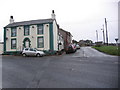
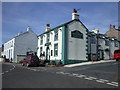
Living in Arlecdon offers a distinct blend of compact urban living and accessible amenities. As a built-up area spanning 33.6 hectares, it is a small but cohesive community in England. The area’s older population, with a median age of 70, suggests a settled, long-term resident base. Daily life here is shaped by proximity to essential services, including four rail stations—Parton, Corkickle, and Whitehaven—which connect residents to broader regional networks. The low crime risk score of 77 indicates a safe environment, though the area’s compact size means it is not suited for those seeking sprawling landscapes. For buyers, Arlecdon’s appeal lies in its practicality: homes are predominantly owner-occupied, with 74% of properties in private hands, and the community is served by a primary school and nearby retail options. While not a destination for young professionals, it caters to those prioritising security, simplicity, and proximity to transport links.
- Area Type
- Built Up Area 250
- Area Size
- 33.6 hectares
- Population
- Not available
- Population Density
- Not available
Residents of Arlecdon have access to a modest selection of retail amenities, including Spar Main, Budgens Four, and Budgens Crossfield, which offer everyday shopping needs. The area’s rail stations—Parton, Corkickle, and Whitehaven—provide direct links to regional transport hubs, facilitating travel to larger towns or cities. While the data does not mention parks or leisure facilities, the presence of multiple retail outlets and rail connections suggests a focus on practicality over recreational amenities. The compact nature of the area means daily life is centred around local services, with limited scope for expansive leisure activities. For those prioritising convenience and connectivity over expansive green spaces or cultural hubs, Arlecdon’s lifestyle is functional, though not particularly vibrant.
Amenities
Schools
The nearest school to Arlecdon is Arlecdon Primary School, which serves the local community. As a primary school, it caters to children aged 4–11, though no Ofsted rating is provided in the data. The presence of a primary school suggests that families with young children may find the area suitable, though the absence of secondary schools or further education institutions nearby means students would need to travel for higher education. The single listed school indicates a limited range of educational options, which could be a consideration for parents seeking a variety of school types. Without additional data on school performance or capacity, prospective buyers must rely on the basic availability of a primary school when assessing the area’s suitability for families.
| Rank | A + A* % | School | Type | Entry gender | Ages |
|---|---|---|---|---|---|
| 1 | N/A | Arlecdon Primary School | primary | N/A | N/A |
| 2 | N/A | Arlecdon Primary School | primary | N/A | N/A |
Explore more schools in this area
Go to Schools tabDemographics
Arlecdon’s demographic profile is defined by its older population, with a median age of 70, suggesting a community largely composed of retirees or long-term residents. The home ownership rate of 74% indicates a stable housing market, with most properties held by private owners rather than landlords. However, the data provides no specifics on household composition, accommodation types, or ethnic diversity, meaning these aspects remain unclear. The absence of detailed information on deprivation or income levels means it is difficult to assess how quality of life might be affected by economic factors. What is clear is that the area’s age profile shapes its character: services and amenities are tailored to older residents, with limited focus on youth-oriented facilities. This demographic trend influences local needs, from healthcare access to leisure options, but the data does not extend beyond these basic metrics.
Household Size
Accommodation Type
Tenure
Ethnic Group
Religion
Household Composition
Age
Household Deprivation
NS-SEC
Explore more demographic insights in this area
Go to Demographics tabPlanning
Planning Constraints
- Crime RiskLocked