Area Overview for Walker Ward
Photos of Walker Ward
Area Information
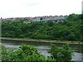
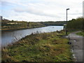
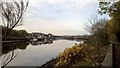
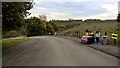
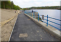
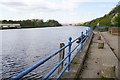
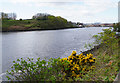
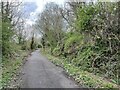
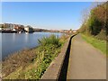
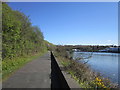
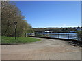
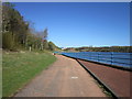
Walker Ward is a residential suburb and electoral ward located in the south-east of Newcastle upon Tyne within Tyne and Wear. The area sits between Welbeck Road and the banks of the River Tyne. This district encompasses distinct neighbourhoods including Pottery Bank, St Anthony's, Daisy Hill, Eastfield, Walkergate, Walkerdene, and Walkerville. With a total area of 3.2 km², Walker Ward functions as a tightly knit community. The population stands at 4,221 people, creating a close-knit environment typical of smaller urban wards. The location offers direct proximity to the River Tyne, providing views and access to waterside areas. Historical industries such as coal mining, shipbuilding, and iron-making have shaped the local character, though these sectors have declined over the past 50 years. Modern infrastructure includes significant recreational spaces like Walker Park, which held a Green Flag Award in 2019, and Walker Riverside Park. The Walkerville development remains a notable feature, exemplifying early 20th-century garden city-style model housing designed in 1908. Residents also have access to Lightfoot Sports Centre, which is currently undergoing a £2.5m refurbishment. Frosterley's former civic buildings, including the library built in 1908 by Alderman Sir William Haswell Stephenson, now occupy the Activity Dome. Living in Walker Ward means residing in a space where history meets modern convenience within a compact urban footprint.
- Area Type
- District Borough Unitary Ward
- Area Size
- 3.2 km²
- Population
- 4221
- Population Density
- 1324 people/km²
Demographics
The community profile of Walker Ward reveals an older demographic leaning heavily towards retirement. The median age is 70 years, meaning half the population is older than this threshold. This aligns with the presence of Walkerville, a planned housing exhibition developed in 1908 to exemplify early 20th-century garden city principles. The predominant age range covers the entire spectrum, though the high median suggests a cluster of older residents. Property ownership is consistent with national retirement trends. Only 25% of residents own their homes outright. This indicates that the majority of households are likely renters or mortgage-holders rather than owner-occupiers. Accommodation types and household compositions vary within the 3.2 km² ward, reflecting a mix of council, ex-council, and private housing stock. The diversity of the population in terms of ethnicity, religion, and household size is recorded as a total category, indicating the ward captures the broader demographic spread of the region. With 1,324 people per square kilometre, the density of 1324 people/km² ensures que neighbours and local services remain within easy reach. This high density supports the 4,221 population by maintaining a vibrant urban feel without the isolation often found in suburban estates.
Household Size
Accommodation Type
Tenure
Ethnic Group
Religion
Household Composition
Age
Household Deprivation
NS-SEC
Explore more demographic insights in this area
Go to Demographics tabPlanning
Planning Constraints
- Flood RiskPremium
- Ramsar Wetland SitesPremium
- Area of Outstanding Natural BeautyPremium
- Protected Nature ReservePremium
- Protected WoodlandPremium
- Crime RiskPremium